Camp site 8 June 2015
Week forty of ice drift (01 - 08 June 2015)
Ice drift
The ice camp drifted 35 nautical miles (65 km) along the lower continental slope of Northeast Greenland during the week. The northward motion we experienced at the end of week 39 turned west and south in the morning of Tuesday 2 June. We were now under influence of an extensive low pressure which had moved along the coast of northern Norway during the weekend and proceeded towards the North Pole area via Franz Josef Land. Winds were now from the north at speeds of 22-35 knots. The ice drift was a pleasant 0.3 knot all Wednesday 3 June through Saturday 6 June. With the warm wind (-3 °C to -5 °C) followed low clouds and poor visibility, but the weekend had glorious weather.
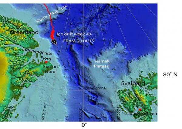
Fig. 1. The drift of FRAM-2014/15 during week 40, 01- 08 June 2015 (short heavy red line).
Sea ice dynamics
No ice activity was been observed in our neighborhood until Friday afternoon. Three parallel cracks, about 10 cm wide, opened through our ice floe; one right behind the hovercraft skirt, and another one between the craft and the radiation flux instrument and weather mast. The satellite image in Fig. 2 shows that the regional scale leads have closed in the situation where the forcing wind field is from the north and Northeast Greenland represents a buttress.
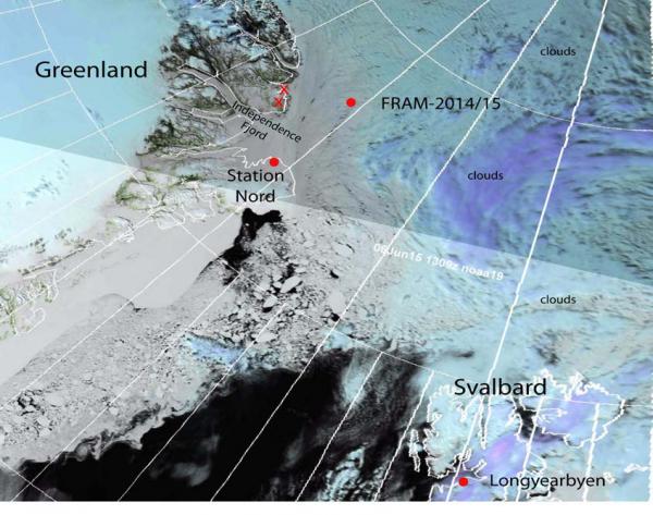
Fig. 2 Satellite image from 06 June courtesy of www.woksat.info showing ice distribution and fracture patterns north of Greenland and Svalbard. The mountains sighted in Northeast Greenland on the north side of Independence Fjord indicated by red "X" are Wyckoff Bjerge (northwest) and Kim Fjelde in the southeast.
Camp life
Temperatures have been between -5 °C and -3 °C and even above zero during the weekend. The warm weather is something to get adjusted to. The melting effect is visible everywhere, the snow gets "rotten" - you sink in. Cracks that develop in our neighborhood will not heal by freezing so we get an idea what to prepare for. We have just moved all loose items to a seemingly intact area behind the hovercraft. However, the hovercraft, the hydro hole, the and work space is isolated on a separate 20 meter wide elongated strip of ice - a long stride takes you across the crack in between. The radiation flux instrument and the weather station are once again on a separate floe. We consider the safety risk minimal and will stay like this for the time being, because of the work that needs to be invested in order to relocate and make a new hole in the 2 meter thick ice. If necessary, it is a matter of disconnecting the two hydraulic hoses to the winch, start the hovercraft and move off. Our limited experience suggests that if cracks start to penetrate the camp area, locate the nearest 100-200 meter wide property free of incipient cracks and claim it. There is little point in expending energy
going off in a distance. As the ice activity gets more dynamic farther south, we foresee a challenge in keeping the cargo on the ice together. In the case of the thermistor string, the mooring moved over night 350 meter away from us in a shear zone, not only 150 meter as we originally estimated. Ironically, we will depend on the ice breaking up, because our neighborhood is far too chaotic for hovercraft driving - we need leads and slack ice to move in between.
Saturday was a very clear day and brought a lot of excitement. We walked and skied out to the site of the bathymetry buoy #2, about 1.7 km from the camp. The task was to recover the hydrophone below the 2.5 thick ice. A four meter high ice block in a nearby pressure ridge presented a look-out point. Audun shouted "I see land", but was met with skepticism. The two darker areas on the horizon could be drifting ice islands, however the satellite pictures show none. With time we could clearly see the nearest mountains of Northeast Greenland; Wyckoff Bjerge (bearing 247°) and Kim Fjelde (bearing 238°) at a distance of about 100 kilometer (marked with red "X" in Fig. 2). This was a great feeling; first sight of land since the beginning of August last year.
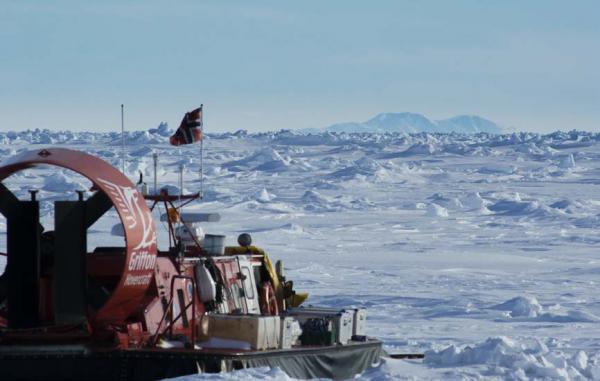
Fig. 4 Land in sight! Wyckoff Bjerge in Northeast Greenland about 100 km away is seen in the background
Science
Underway continuous measurements:
Bathymetry and sub-bottom profiling:
- echo sounder (autonomous bathymetry buoy made by Chr. Michelsen Research)
Oceanography:
- current meter suspended at 150 meter below the ice.
- 50 kHz and 200 kHz echo sounders to check for scattering layers in the upper 200 meter.
Atmosphere:
- measurement of incoming and outgoing radiation from the ice surface
- surface infrared skin temperature
- sun time
- Aanderaa weather station
Station work
- 5 CTD casts to 1000 meter depth
The fast drift and southward progress during the week was a relief. Although some data are collected no matter what the drift is, moving south has a positive psychological effect. Also, every new CTD cast means we have moved 5 nautical miles.
To get bathymetry in camp, we have activated an autonomous buoy which use a Syquest echo sounder. For the time being, it transmits via Iridium to Chr. Michelsen Research in Bergen to tune the parameters for optimum results. We have also suspended a current meter at 150 meter depth through the hydro hole.
The five autonomous bathymetry buoys deployed in September last year have all stopped working for various reasons. We know one has been taken by ice, and the instrument cases for the two closest sites (1.7 and 4.7 km from camp) have been recovered. On Saturday, we recovered the hydrophone below the 2.5 m thick ice at the closest site, 1.7 km away (Fig. 4). The idea is to try and activate one in camp in order to explore what the problems are. We have also recovered the instrument case of a mass balance buoy for the Finnish Meterological Institute and checked the ice thickness (187 cm) at the site near our old camp.
Fig. 4. Drilling for recovery of the hydrophone of the autonomous buoy
Wild life
Ivory gulls are visiting every day, but have not yet encountered signs of polar bears since we spotted tracks of a polar bear and possibly two cubs in our camp on October 10 2014 at 89° N, 177° E.
Life in the High Arctic is treating us well.
Yngve Kristoffersen & Audun Tholfsen
Daily reports
Monday 01 June
Position: 83° 44.8' N, 16° 18' W, temperature - 6 °C, 1028 hPa, wind 9 knots from the NW. Ice drift 0.1 towards W. Checked the radiation flux instrument and the weather station. Deployed our Aanderaa SeaGuard current to 150 meter depth in the hydro hole to record for the rest of the drift. Audun recovered the Finnish mass balance buoy which had stopped working. The buoy was located in the old camp area. Burned all remaining garbage in the old camp area. Two Ivory gulls came by our site today.
Tuesday 02 June
Position: 83° 44.15' N, 16° 24.7' W, temperature - 3 °C, 1030 hPa, wind 6 knot knots from the ENE. Ice drift 0.1 knot towards the S. Downloaded data for the last month from the radiation flux instrument. Hovercraft maintenance all day. A snow bunting was found dead - we had noticed the bird seemed to be physically reduced during the last few days.
Wednesday 03 June
Position: 83° 39.7' N, 16° 24' W, temperature - 3 °C, 1022 hPa, wind 22 knots from the N. Ice drift 0.3 knot to the SSE. Worked on the weekly report.
Thursday 04 June
Position: 83° 31.95' N, 16° 06.9' W, temperature - 5 °C, air pressure 1018 hPa, wind 32 knots from the N. Ice drift 0.3 knot towards SSE. Deployed the Syquest echo sounder of the autonomous buoy made by Chr. Michelsen Research to obtain bathymetry from the camp site. Iridium transmission was deactivated and recording is on internal memory with a 10 minute repetition rate. Made two CTD casts down to 1000 meter.
Friday 05 June
Position: 83° 23.4' N, 15° 36.7' W, temperature - 5 °C, pressure 1015 hPa, wind 23 knots from the NNW. Ice drift 0.3 knot towards the S. Made a CTD cast down to 1000 meter depth. Finished transfer of all logs to Exel format. Discovered a band of 3 parallel cracks trending NW_SE across our floe. Hovercraft azimuth is 240 degrees. One of the cracks is right behind the stern skirt, and one crack separates the craft from the radiation flux instrument and the weather station. Cracks are 10 cm wide.
Saturday 06 June
Position: 83° 19.5' N, 15° 15.7' W. Ice drift 0.3 knot towards the SE. A glorious day. The AirMar weather station on the hovercraft went down. Made a CTD cast to 1000 meter depth. Went out on skis and on foot to bathymetry buoy #2 , 1.7 km out. The buoy was located in a 50 meter wide flat area surrounded by a maze of pressure ridges. We drilled a 15 cm diam. Inspection hole through 2.5 meter thick ice and checked with the underwater camera. The hydrophone cable was hooked and the hydrophone recovered by cutting the cable. From a look-out point on a high pressure ridge, we could clearly see two mountains in Trolle Land, Northeast Greenland about 110 km away. This was Wyckoff Bjerge at a bearing of 247 degrees and Kim Bjerge at a bearing of 238 degrees (Fig. ?). This was exciting! All equipment was returned to camp from the buoy site.
Sunday 07 June
Position: 83° 15.8' N, 14° 45' W, wind 7 knots from the SE. Ice drift 0.1 knot to the ESE. Made CTD cast down to 800 meter as winch did not function properly. Checked radiation flux instrument - battery 12.07 volt. Checked floation tanks in the cabin for water from condensation - emptied 6 liter out of the tank below the work bench. Audun went for a ski trip. Two Ivory gulls over the camp in the evening. The crack behind the hovercraft has widened to 0.5 meter.