The fate of the sea ice platform
The FRAM-2014/15 camp reached the ice edge about mid-July (Fig. 1 and 2). The ice edge is a dynamic transition zone where the solid sea ice cover from the north rapidly disintegrates and permits melting to intensify. Smaller floes progressively move unconstrained driven by the wind, currents and the tides. A local “jet stream” of ice during the third week in July dramatically accelerated floe dispersal (Fig. 2). The sea ice drift in August was to the southwest and then back in a northeast direction south of Nordostrundingen (Figs. 3 and 4). In detail, the drift track was dominated by a pattern of nested cycloids generated by the influence of tidal currents.
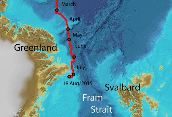
Fig. 1. The drift of FRAM-2014/15 northeast of Greenland
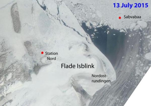
Fig. 2 The ice situation as it developed during the second half of July. The two upper satellite images are courtesy of Danish Meterological Institute. Processing of the lower image courtesy of M. Babiker, NERSC.
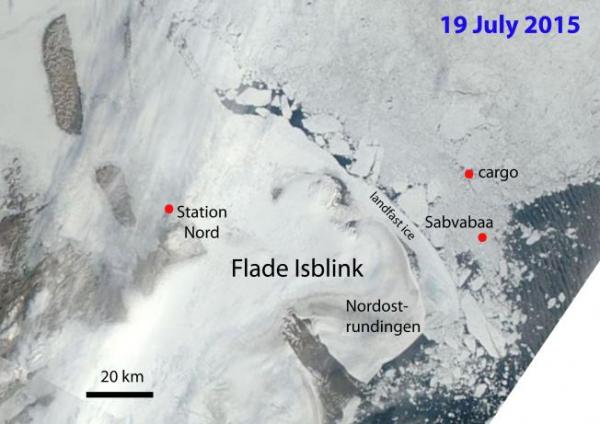
Fig. 3. Landsat images displaying the ice situation in early August while the hovercraft was parked on landfast ice. Image processing courtesy of M. Babiker, NERSC.
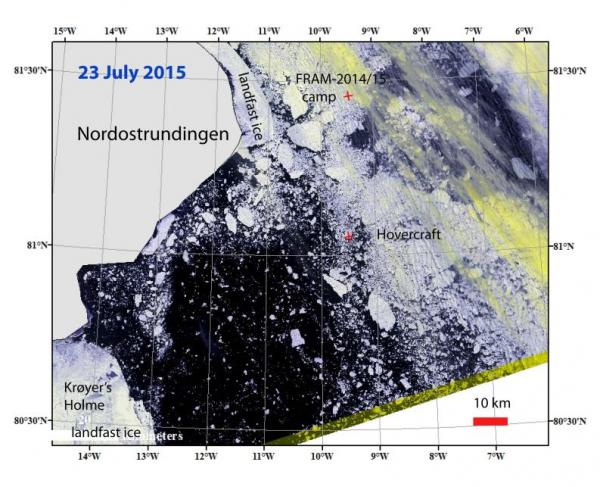
Fig. 4 The ice situation on 14 August (last useable image before camp recovery). Image courtesy of Danish Meterological Institute
By 12 August, the camp site was still part of a floe at least over 1 km across, but the size appears only as a tiny spec on the satellite picture obtained on 14 August (Fig. 4). At this time, the floe started to deteriorate dramatically. Melt ponds had in several places penetrated the entire floe and weakened it. During relatively minor collisions with other floes, sections were knocked off and by the 17 August the size of the floe was about 100 meter long and 70 meter across (Fig. 5. lower right). The cargo placed on top of the pressure ridge had survived reasonably well for nearly six weeks during the height of the summer melt season. Some boxes had rolled off the ridge, but not into any melt ponds. The sequence of events during the last months of the life of the ice floe are shown in Fig. 5.
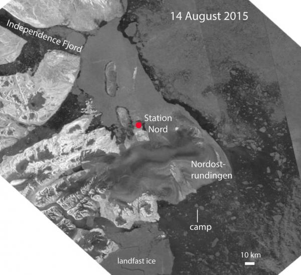
Fig. 5. The state of the sea ice cover in the vicinity of the camp from April to recovery on 18 August 2015.
General sea ice condtions and ice camp recovery
The surface of first year sea ice in August 2014 at the FRAM-2014/15 camp site and vicinity was level with distant minor pressure ridges. The location was 87° 30’ N, 156° E in the Makarov Basin. The hovercraft was used to deploy five autonomous bathymetry buoys over a 6 km wide area with no problems during the first week of September. During the winter, several ridging events transformed the level ice to a network of pressure ridges which in many cases implied under-thrusting and locally more than double normal ice thickness. When daylight returned, hovercraft driving was not possible except locally, and the mechanically thickened sea ice rendered the area inaccessible to diesel-driven ice breakers given any reasonable effort. An attempt to transfer cargo by helicopter to POLARSTERN at 82° N on July 6 was aborted due to time constraints. At the closest point, the ship was 11 nautical miles away.
We estimate that during the last half of July, the ice conditions became relaxed enough for recovery by an icebreaker without assistance of helicopter.
Recovery by the sealing vessel HAVSEL
The sealer HAVSEL had been under charter around Svalbard up until 15 August. HAVSEL left Longyearbyen at 1400 hours that day for Northeast Greenland and the FRAM-2014/15 ice floe. Guided by satellite imagery received from NERSC, the course was north along the coast of East Greenland landward of the outflow of ice from the north (Fig. 6)
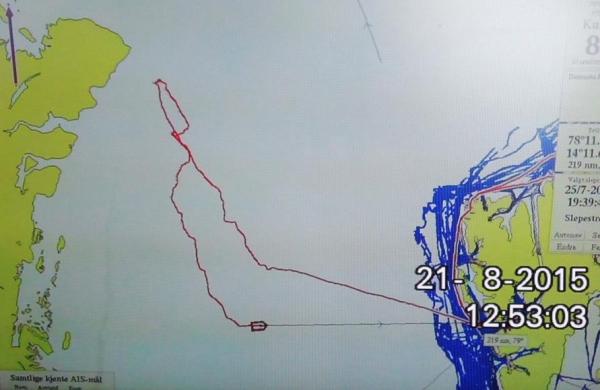
Fig. 6 Track of the sealing vessel HAVSEL to recover the FRAM-2014/15 ekspedition.
The vessel arrived the floe position at 0600 hours on 18 August in fog (Fig. 5, lower right). All equipment and waste was recovered from the ice floe (Fig. 7), the hovercraft was refueled and the craft and the vessel departed at 1600 hours. Heavy ice was met around midnight and the parties stopped for the night. The transit continued the next morning after breakfast with HAVSEL and the hovercraft moving in tandem. At lunch time the hovercraft parked on an ice floe and the vessel hove to to allow the crews a joint meal (Fig. 8, upper panel). As the hovercraft made another stop on an ice floe in the late afternoon to await the arrival of HAVSEL, one of the two rods bracing the propeller housing, broke off. The housing vibrated and before coming to rest, the tip of the four-blade propeller shaved off the fiber glass surface on the inside of the housing, and one of the propeller blades broke off. The belt driving the propeller was now removed, and the journey continued with the hovercraft under tow in a hover-up position. It had been the intent to tow the hovercraft after HAVSEL during the open ocean crossing of the Fram Strait, but now the tow had to be effected immediately. The transit across the Fram Strait went smooth in calm seas (Fig. 8).
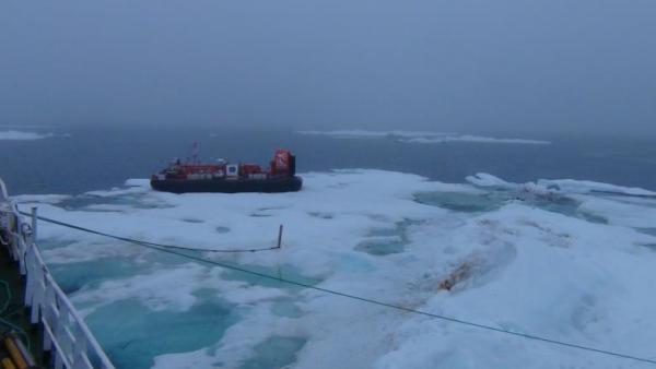
Fig. 7. All equipment and camp waste have been recovered from the ice floe.
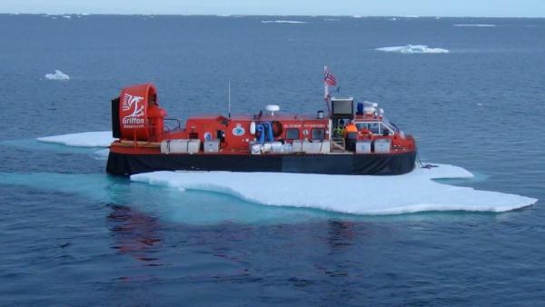
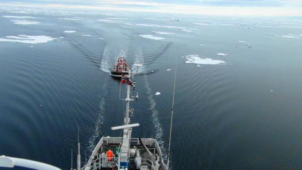
Fig. 8 Upper: A rest stop on the way south along the coast of Northeast Greenland
Lower: HAVSEL with the hovercraft under tow leaving the ice edge in the Fram Strait.
Arriving Svalbard - Mission completed
HAVSEL and the hovercraft arrived Longyearbyen at 1500 hours 22 August and docked at the Coal Pier (Kullkaia). The expedition was welcomed by NERSC representative Lasse Petterson and the research vessel Håkon Mosby fully decorated by flags at Bykaia, a nearby dock site (Fig. 9). Professor Snorre Olaussen (UNIS) presented champagne at the pier out of personal enthusiasm over the year-long achievement (Fig. 10). The hovercraft was subsequently towed to shore in hover-up position and pulled up towards its regular parking area. Later the Governor of Svalbard arrived and greeted us welcome and stayed for a longer informative chat about objectives and events taking place during the ice drift (Fig. 11). A small press conference was held in the mess of HAVSEL (Fig. 12, upper panel) and rounded off by a presentation of a song dedicated to the ice drift, written and presented by professor Tor Gammelsrød (Fig. 12, lower panel).
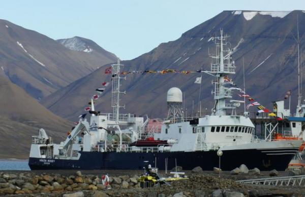
Fig. 9. The research vessel HÅKON MOSBY wishing us welcome.
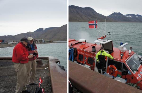
Fig. 10. Champagne to salute mission completed presented by professor Snorre Olaussen (second from the left) with Dr. John K. Hall on the dock.

Fig. 11. Governor of Svalbard, Odd Ingerød being briefed about the year on the ice.
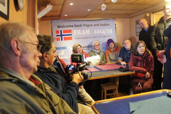
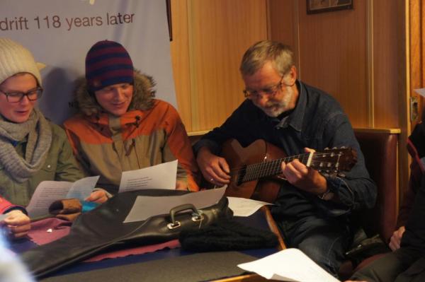
Fig. 12 Upper: From the press conference in the mess of HAVSEL.
Lower: T. Gammelsrød presenting his ode to SABVABAA
Acknowledgement
We thank our cooperating partner A. Wegener Institute for Polar and Marine Research, Germany for showing us the confidence in deployment of FRAM-2014/15. The two support missions by the 333 Squadron of the Norwegian Air Force and one by the Danish Air Force ensured that we could continue the science operations at a high level in spite of the field challenges during the winter. A. Heiberg, University of Seattle provided helpful advice at the planning stage. Technical support from Griffon Hoverwork, Southampton on hovercraft maintenance, from Chief Engineer H. Berge (retired) on mechanical issues, from PhD. student G. Hope on computer issues and Senior Engineer O. Meyer on electronics issues, were all crucial to maximize up-time throughout the year and contributed to the safety of the expedition. The backing of the Blodgett-Hall Polar Presence LLT providing the hovercraft platform and support supplemented by Lundin Norway and the Norwegian Petroleum Directorate made the first Norwegian ice drift in 118 years possible.
A year in the High Arctic on the drifting sea is over. Life treated us well and the endeavor ended well.
Yngve Kristoffersen and Audun Tholfsen
Epilogue
An expedition like FRAM-2014/15 requires a scientific idea, a logistic solution, preparations and funding.
The scientific idea
The scientific idea behind the FRAM-2014/15 expedition grew out of results obtained from the legendary U.S. ice island Fletcher’s Island or T-3 (radar target # 3) which was discovered on the coast of Arctic Canada about 1948 and drifted out of the Arctic Ocean through the Fram Strait in 1983 after three loops in the Beaufort Gyre. Lamont-Doherty Geological Observatory of Columbia University of New York operated a geophysical program which included acquisition of seismic data and a PhD student, John K. Hall had several tours of duty. The data showed apparent wavy sea bed in areas on the Alpha Ridge, and was interpreted as sediments deposited under the influence of bottom currents – a paradigm at the time. Mysteriously, 3 out of the more than 400 short (3 meter) sediments cores obtained from the ice island in the area contained 50-70 million year old sediments at the sea bed – yet nobody questioned why? One of the cores contained a one meter long interval of black mud and has received a lot of scientific attention. The black mud suggests an oxygen-poor oceanic environment.
After 1991, new multi-channel seismic data started to become available and the activity accelerated after 2001 as the circum-arctic nations had a need to document claims to extend their respective Exclusive Economic Zones. The data showed a drape, about 200 meter thick present everywhere in the deep Arctic Ocean except in an area on the Alpha Ridge (25 meter). A new look at the T-3 seismic data from Alpha Ridge after year 2000 revealed deformed sediments at the sea bed and massive submarine slides within an 200 x 600 km area. The icebreaker Healy traversed the outskirts of this area in 2005 and the modern multi-channel data showed sediment had been removed and deformation decreased with depth below the sea bed. The multitude of observations were now explained as the possible effect of a pressure wave from the impact of asteroid fragments: This idea was published in the Norwegian Journal of Geology in 2007 after earlier attempts had been rejected by two other journals.
The idea of an asteroid impact was exciting, but more important was the realization that this area represented a treasure chest for access to Early Cenozoic and Late Cretaceous stratigraphy without the need for scientific drilling.
The logistic approach
We brought a small hovercraft to the North Pole in 1991 on the icebreaker Polarstern, but the craft was of limited use. In 1992, the Norwegian Research Council funded a small feasibility study which included video recording of the sea ice surface from 150 meter altitude over a distance of 250 kilometer and field test of a hovercraft north of Svalbard. This study was the basis for an application in 1993 from the University of Bergen, Nansen Environmental and Remote Sensing Centre, A. Wegener Institute of Polar and Marine Research (GER) and Scott Polar Research Institute (UK) to the European Marine Science and Technology program for funds to test hovercraft as a science platform in the Arctic Ocean - the response was negative. The report from the feasibility study later caught the interest of Rieber Shipping, a provider of ice-going vessels for many scientific expeditions to Antarctica. The company Board decided in 1996 to acquire a medium-sized hovercraft (4 ton pay load) to be stationed in Svalbard to serve as a research platform for hire. However, the idea was not well received by the Governors’s office and not pursued further.
In 2004, Dr. John K. Hall, marine geophysicist with the Geological Survey of Israel visited University of Bergen to discuss the seismic data over Alpha Ridge acquired from the ice island T-3 by him as a graduate student in the late 1960-ties. The issue of how to get to Alpha Ridge came up and the hovercraft alternative was tabled. The enthusiastic discussion was concluded with the statement “let us buy one”. The contract for a polar research platform based on hovercraft technology was signed in Southampton in the fall of 2007 and the craft arrived in Longyearbyen in June 2008.
Preparing for sea ice operations
Efficient use of the hovercraft required: 1) driving skills over sea ice; 2) learning the strength and weaknesses of the hovercraft technology, and 3) adapting and/or developing geological/geophysical tools tailored to a hovercraft platform. The hovercraft arrived at the start of the International Polar Year and by chance became the platform for an IPY-project: “High school students - building scientific and polar curiosity through participation in a scientific field camp on drifting sea ice”. This activity involved 16 high school students selected from all over Norway to spend a week on the drifting sea ice doing similar measurements as during Nansen’s drift with the ship FRAM, but now with modern technology. A total of eight week-long trips from Longyearbyen to the ice edge were made in 2008 and 2009. The objective of trips in the following years were to obtain rock samples from the sea bed on Yermak Plateau, an natural prolongation of the continental margin north of Svalbard. This activity funded by the Norwegian Petroleum Directorate brought back over 300 kilos of rocks from basement outcrops on the continental and volcanic part of the plateau. The hovercraft ventured up to 90 nautical miles north of the ice edge on trips lasting up of to three weeks. A first venture into the Arctic Ocean was an attempt to reach a work area on the Lomonosov Ridge in 2012 accompanied by the Swedish icebreaker Oden. The summer and fall light conditions had serious impact on trafficability and the time was spent on surveys over the rift valley of Gakkel Ridge at 85° N. A short operation in the Fram Strait in the fall of 2013 was together with the Norwegian Coast Guard vessel Svalbard. In preparation for FRAM-2014/15 endeavour, the hovercraft Sabvabaa had transited over 4.000 kilometer over sea ice, but all during the summer and early fall.
The hovercraft has a limited pay load (2.2 ton) and equipment weight is an issue. This is a particular concern for sediment coring and dredging. The moving sea ice cover provide the force to pull a sediment corer out of the bottom and the required winch capacity is limited to what is needed to lift the equipment through the water column. A sediment corer boosted by the hydrostatic water pressure was developed, tested and patented for use with the hovercraft. In this way the sediment coring capability including 3000 meter kevlar line, a capstan winch and the corer weighed less than 300 kilo in total.
Funding
The proposal for the FRAM-2014/15 expedition was first submitted in the fall of 2013 at a time of change of government in Norway and a petroleum industry in a state of budget cut psycosis. Less than half of the funds needed for operational expences were at hand by the time of departure, but overruled by the consideration that “it is now or never”. The backing of the Blodgett-Hall Polar Presence LLT providing the hovercraft platform and support supplemented by Lundin Norway and the Norwegian Petroleum Directorate made the first Norwegian ice drift in 118 years