
(10 - 17 Nov. 2014)
Ice drift
The ice camp moved about 35 nautical miles (65 km) during the week (Fig. 1), exactly the same distance as last week. By now the ice camp has drifted a total distance of 340 nautical miles. For comparison, it is equivalent to the distance along the road from Oslo to Trondheim plus another 80 kilometer. We moved from the top of Lomonosov Ridge to the area beyond the foot of slope in the Amundsen Basin. With that our primary target for geology and geophysics was behind us and the current weather situation suggests there is little hope for a second return to the ridge. A strong high pressure cell over Banks Island in the Canadian Arctic on Monday developed into a continuous high which extended along the continental margin from Alaska to Svalbard until Friday morning. The associated wind field drove the ice towards the Fram Strait. From Friday onwards, a low pressure trough moving out from the Laptev Sea towards Ellesmere Island had much of the same effect on the sea ice motion. What is needed to drive us back over the Lomonosov Ridge is a strong low pressure moving past Northeast Greenland and into the Arctic Ocean. We have, by the way, slowly gotten an increased affection for low pressure systems - they makes things happen for the better or worse.
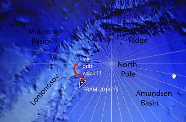
Fig. 1 Drift track of FRAM-2014/15 across Lomonosov Ridge during week 11
Sea ice dynamics
On Tuesday, a two meter wide crack opened between the radiation flux instruments and the hovercraft cutting past our storage area and the fuel pillows. On Sunday it widened to 15 meters, more cracks developed and most of the fuel pillows became isolated on a separate floe. After that it became quiet.
Camp life
We had a brief warm spell on Sunday 9th November and early on Monday with temperatures around - 20° C. After that air temperatures were between - 25° C and - 30° C. The logistics of a simple camp on sea ice is more labor intensive that a scientist would like to acknowledge. Set-backs driven by ice dynamics are the rule and not the exception. Also, just the trivial task of keeping equipment and supplies from disappearing in the shifting snow drifts becomes a full day job at times. At very low temperatures, all tasks become more tedious. If you want to use a piece of equipment, you often have to take it inside and heat it before you get any use of it.
Lomonosov Ridge is only about 80 km wide. Even if the ice drift is slow, the geological tidbits pass by below relatively fast when you are only two people to manage everything. Late Friday night as we drifted over the lover slope of the ridge, the airgun started to fire irregularly. I had the choice between working through the night to fix it or get the first full night sleep in five weeks - I chose the latter. The gun was in the water the next day at 1400 hours. Under these circumstances, we have still not caught up with getting ourselves a decent work area, so this week Audun worked on and off on temporary improvements.
Science
We are overseeing the following suite of continuous measurements:
Bathymetry and sub-bottom profiling:
- five autonomous echo sounder buoys reporting to shore via Iridium
- seismic reflection (0.3 litre air gun & single hydrophone), sub-bottom penetration ̴2 km
Oceanography:
- Acoustic Doppler Current Profiler 0- 500 meter depth
- two Aanderaa current meters at 800 and 1050 meter depth, respectively.
- thermistor string with 30 thermistors from the surface to 300 meter depth.
Atmosphere:
- measurement of incoming and outgoing radiation from the ice surface
- surface infrared skin temperature
- sun time
- Aanderaa weather station (wind, temperature and humidity)
The seismic reflection measurements continued to run well for the fifth consecutive week, but the airgun started trigging irregularly on Friday night. Shooting continued after lunch Saturday. Three of the five autonomous echo sounding buoys have stopped reporting for unknown reasons. The other two, continues to make a sounding and report every three hours as we long as we are over ridge topography.
Earlier, we reported on large back tilted blocks of Mesozoic sediments below the slope on the Makarov Basin side of Lomonosov Ridge. A similar situation is also seen on the Amundsen Basin side as shown in figure 7 in the report for the last day of week 10 and now also the first days of week 11.
During the middle of the week, we crossed an area with abrupt termination of the sub-bottom strata above the unconformity (Fig. 2). This is most likely a slide scar. We have earlier published on the discovery of seven similar slide scars at both edges of Lomonosov Ridge in the central part (ACEX area). The trigging mechanism of these slides remains unknown as Lomonosov Ridge is aseismic at least within the time window covered by the history of instrumental earthquake monitoring.
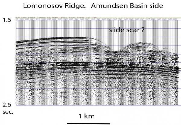
Fig. 2. A possible slide scar at the edge of Lomonosov Ridge
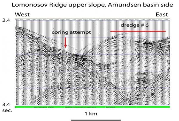
Fig. 3 Location of coring and dredging attempts in an area we presume is within the slide scar.
We first attempted coring in an area of rough bottom topography considered to be within the slide scar (Fig. 3). The corer came up with only mud stains on the core cutter so the bottom must have been hard. Subsequently dredge # 6 was deployed. To our great surprise, the dredge came up empty.
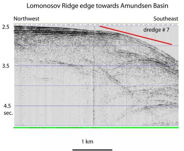
Fig. 4. The edge of Lomonosov Ridge facing the Amundsen Basin
On Friday November 14, we passed over the edge of Lomonosov Ridge and moved down-slope towards the Amundsen Basin (Fig. 4). Diffraction hyperbolae suggested a scarp, but dredging down a slope is not optimal. Dredge # 7 returned a single sharp-edged platy rock specimen.
A fourth deployment of the camera sled was made in 1450 meter water depth on top of Lomonosov Ridge Wednesday November 12. The sled sat on the bottom for a while until the tow line tightened up by the slow drift. The video shows an abundance of copepods. At one point a half-meter long fish comes into the field of view. Both sequences are attached to this report. To the best of our knowledge, this is the first time a fish of this size has been reported from the central Arctic Ocean.
No signs of animal life have been observed on the ice surface during the week
Life is treating us well apart from the unpredictable ice dynamics
Yngve Kristoffersen & Audun Tholfsen
Daily reports
Monday 10 November.
Position: 89° 10.41' N, 88° 56.5' W, temperature - 26° C, air pressure 1028 hPa, wind 5 knots from NE. Ice drift 0.1 knots towards east. Shooting seismic reflection all day. Audun is putting up improved walls for the work area.
Tuesday 11 November..
Position: 89° 08,2' N, 88° 10.7' W, temperature - 27° C, air pressure 1033 hPa, wind 4 knots from NNE. Ice drift 0.1 knots towards southeast. Shooting seismic reflection all day. Audun discovered a new 2 meter wide crack between the radiation flux instruments and the hovercraft continuing past our storage area and the fuel pillows. Some shear motion.
Wednesday 12 November.
Position: 89° 06.2' N, 83° 42.0' W, temperature - 26° C, air pressure 1035 hPa, wind 15 knots from NNE. Ice drift 0.2 knots towards east. Shooting seismic reflection all day. Deployed the camera sled at 0130 hours in 1450 meter water depth. Obtained about 30 minutes of video with sled moving. A half meter long eel- like fish came into view. During the afternoon, we moved over an area looking like a slide scar. Deployed the corer and let it hang at 1000 meter in anticipation of a suitable target.
Thursday 13 November
Position: 89° 06.34' N, 79° 01.3' W, temperature - 26° C, air pressure 1034 hPa, wind 19 knots from NNW. Ice drift 0.2 knots toward east. Shooting seismic reflection all day. Starts the decent from the top of Lomonosov Ridge down the slope towards Amundsen Basin. Dropped the corer to the bottom in 2050 meter water depth. The corer was recovered with only mud on the core cutter. Dropped the dredge in 2170 meter water depth. The new ice crack in the camp area had widened to about 3 meter.
Friday 14 November.
Position: 89° 09.0' N, 71° 44.5' W, temperature - 20° C, air pressure 1027 hPa, wind 27 knots from WNW. Ice drift 0.4 knots towards east. Shooting seismic reflection all day. This is the position of the outcrop of the major unconformity. Recovered the dredge, only one rock specimen with sharp edges recovered. The Kevlar line had disintegrated between 100 and 200 meter, we had to cut the line after recovering the dredge. Airgun started to fire only occasionally, had to recover the gun for maintenance. The through-going 3 meter wide crack had come together with build-up of a small pressure ridge. Could now reconnect power to the radiation flux instruments. The radiation instruments are fine, but the sun time and IP sensors had to be cleared for frost and snow.
Saturday 15 November.
Position: 89° 13.59' N, 66° 18.48' W, temperature - 30° C, air pressure 1009 hPa, wind 13 knots from WNW. Ice drift 0.2 knots towards northeast. The air gun in the water at 1400 hours and resume shooting seismic reflection. Checked the GFI weather
station, all covered with frost, but the wind speed rotor was working good. Also checked radiation flux instruments and removed rime from sun time sensor and snow from IR sensor. Audun remeasured present direction of our initial North-South direction.
Sunday 16 November.
Position: 89° 11.24' N, 61° 11.8' W, temperature - 30° C, air pressure 1009 hPa, wind 13 knots from NNW. Ice drift 0.3 knot towards southeast. Shooting seismic reflection all day. Continues work on the wall to improve work space. The large through- going crack has widened to 15 meters and pressure motion started. Most of the fuel pillows are now isolated on a separate floe with 15 meter wide lead in between.