You are here

Events

Error message

  • Deprecated function: preg_match(): Passing null to parameter #2 ($subject) of type string is deprecated in drupal_match_path() (line 331 of /var/www/html/drupal7/web/includes/path.inc).
  • Deprecated function: preg_match(): Passing null to parameter #2 ($subject) of type string is deprecated in drupal_match_path() (line 331 of /var/www/html/drupal7/web/includes/path.inc).

MISSION COMPLETED: Arrival at Kullkaia in Longyearbyen 22. August 2015 17:00.

Press release

Nansen Center (http://www.nersc.no), Longyearbyen/Bergen, Norway 22. August 2015

MISSION COMPLETED:
FRAM-2014/15 expedition arrived in Longyearbyen after one year drift across the Arctic Ocean

Ice drift station FRAM-2014/15 summary

Why ice drift stations?
An ice drift station is a logistic alternative to:

FRAM 2014/15 reunioned with the Camp on 9th August

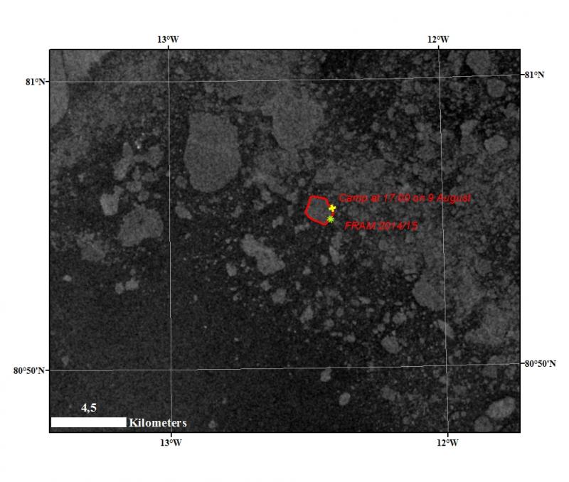
Sabvabaa moved back to the ice floe where the camp is located.
On the attached Sentinel-1 image the locations of the camp and Sabvabaa is located on 9th August 1t 17hr00.

Landsat image 03 August 2015

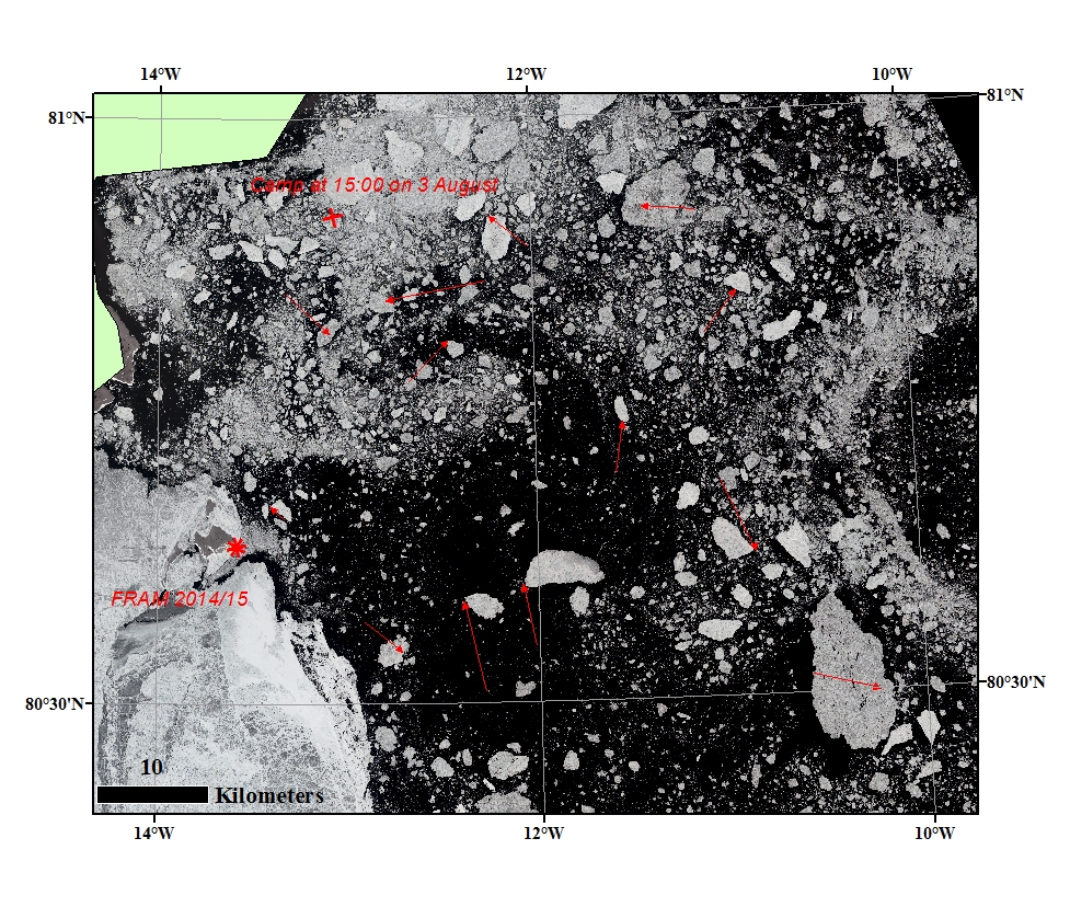
The sea ice condition around FRAM 2014-15 from Landsat image of the 03 August at 15:20. The icedrift displacement for the last 24 hours is indicated -it shows different direction and size. The camp at 14:00 are demarcated (x).
The position of the hovercraft SABVABAA (*) on landfast sea ice ca. 1 km SE of the eastern tip of Krøyer's Holme.

Landsat image 02 August 2015

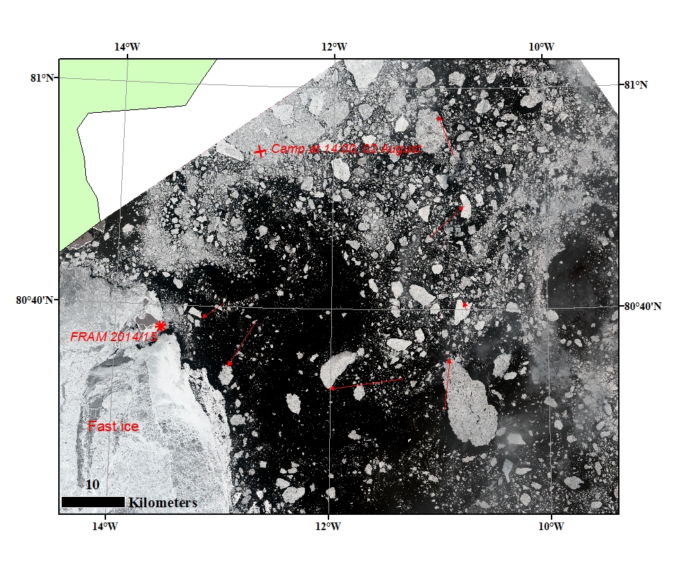
The sea ice condition around FRAM 2014-15 from Landsat image of the 02 August at 14:37. The icedrift displacement for the last 30 hours is indicated -it shows different direction and size. The camp at 14:00 are demarcated (x).
The position of the hovercraft SABVABAA (*) on landfast sea ice ca. 1 km SE of the eastern tip of Krøyer's Holme.

On landfast ice - near Krøyers Holme

The position of the hovercraft SABVABAA as of 1140 GMT 31 July, 2015 is: 80 38.05' N, 13 34.90' W
on landfast sea ice ca. 1 km SE of the eastern tip of Krøyer's Holme.
Towards Greenland 29 July 2015
We took advantage of a good ice situation this morning and moved farther onto the ice, as our first location was just at the edge of the landfast ice.

Sentinel-1 image 30 July 2015

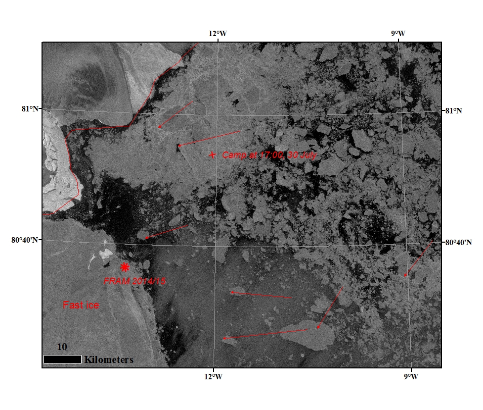
The sea ice condition around FRAM 2014-15 from Sentinel-1image of the 30 July at 16:59. The icedrift displacement for the last 30 hours is indicated -it shows west to south-west directions. The camp at 17:00 are demarcated (x).
Sabvabaa (*) is now located on the edge of the landfast ice approx. 3.1 nm southwest of Henrik Kroyers Holme.

Sentinel-1 image 29 July 2015

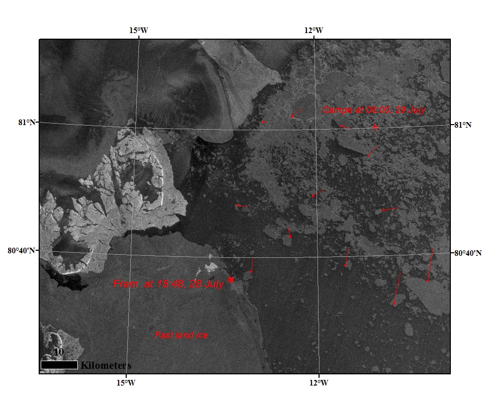
The sea ice condition around FRAM 2014-15 from Sentinel-1image of the 29 July at 08:09. The icedrift displacement for the last 15 hours is indicated -it shows different magnitude and directions.
Sabvabaa is now located on the edge of the landfast ice approx. 3.1 nm southwest of Henrik Kroyers Holme.

Landsat image 28 July 2015

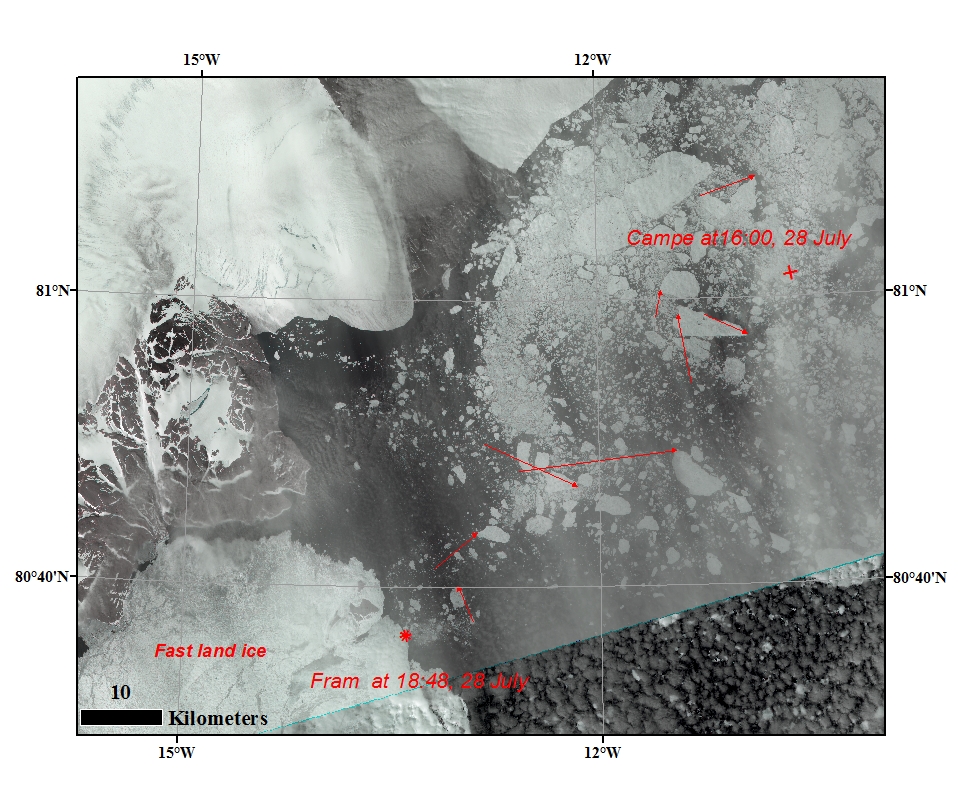
The sea ice condition around FRAM 2014-15 from Landsat image of the 28 July at 15:57. The icedrift displacement for the last 24 hours is indicated -it shows different magnitude and directions.
Sabvabaa is now located on the edge of the landfast ice approx. 3.1 nm southwest of Henrik Kroyers Holme.

MODIS image 28 July 2015

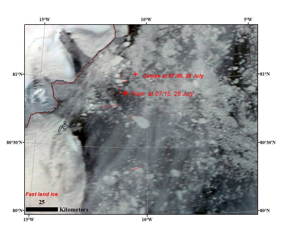
The sea ice condition around FRAM 2014-15 from MODIS image of the 28 July. The icedrift displacement for the last 24 hours is indicated. Fram 2014-15 and the camp at 07:00 are demarcated.

Landsat image 27 July 2015

The sea ice condition around FRAM 2014-15 from Landsat image of the 27 July at 15:15. The icedrift displacement for the last 7 hours is indicated -it shows different size and directions, around Fram is North to North-west direction. Fram 2014-15 position at different time is demarcated and it is drifting North. the camp at 17:00 are demarcated.

Sentinel-1 image 27 July 2015

The sea ice condition around FRAM 2014-15 from Sentinel-1 image of the 27 July at 8:25. The icedrift displacement for the last 15 hours is indicated - about 3.75 kilometer in North-east diction around Fram 2014-15. Fram 2014-15 and the camp at 08:20 are demarcated.

Sentinel-1 image 26 July 2015

Overview of the sea ice condition around FRAM 2014-15 from Sentinel-1 image of the 26 July at 17:32.

Landsat image 23 July 2015

The sea ice condition around FRAM 2014-15 from Landsat image of the 23 July at 15:38. The location of Fram 2014-15 and the camp are demarcated.

Sentinel-1 image 20 July 2015

The sea ice condition around FRAM 2014-15 from Sentinel-1 image of the 20 July at 8:34. The icedrift displacement the from last 16 hours is indicated - about 8 kilometer in southeasterly direction. Fram 2014-15 at 6:40 are demarcated.

Landsat image 19 July 2015

The sea ice condition around FRAM 2014-15. The icedrift displacement the last 24 hours is about 6 kilometer in packed ice and 15 Km in the open ice towards Greenland in southeasterly direction. The Fram 2014-15 location at 14:45 are demarcated.

Landsat image 17 July 2015

The sea ice condition around FRAM 2014-15. The icedrift displacement the last 24 hours is indicated - about 4.5 kilometer in southwesterly direction. The Bathymetry buoy at 16:00 and Fram 2014-15 are demarcated.

View towards Greenland - 17. July

Picture taken at 1000 GMT by the roof camera at 13 m above the ground in the direction Greenland.
Position: 81 47.81' N, 11 02.79' W.

Landsat image 16 July 2015

The sea ice condition around FRAM 2014-15. The icedrift displacement the last 24 hours is indicated - about 5.75 kilometer in southwesterly direction.

Landsat image 15 July 2015

The sea ice condition around FRAM 2014-15. The icedrift displacement the last 24 hours is indicated - about 7.5 kilometer in southwesterly direction.

Pages