
(26 Jan.- 2 Febr. 2015)
Ice drift
The ice camp moved 31 nautical miles (57 km) during the week. The motion was to the west over the slope of Lomonosov Ridge into the Makarov Basin (Fig. 1). During the first four days of the week a ridge of high surface air pressure extended from the Bering Strait to the North Pole, but the effect of a low pressure cell over the Canadian Arctic Islands set the ice in motion to the west. Winds from the northeast were up to 36 knots and the drift speeds exceeded 0.6 knots. The time between seismic shots at 25 meter intervals was less than 80 seconds. The low pressure weakened on Thursday and was replaced by a surface air pressure high between Greenland and the Beaufort Sea. From Thursday onwards, the winds were less than 10 knots. On Sunday morning, our drift direction turned south for a while.
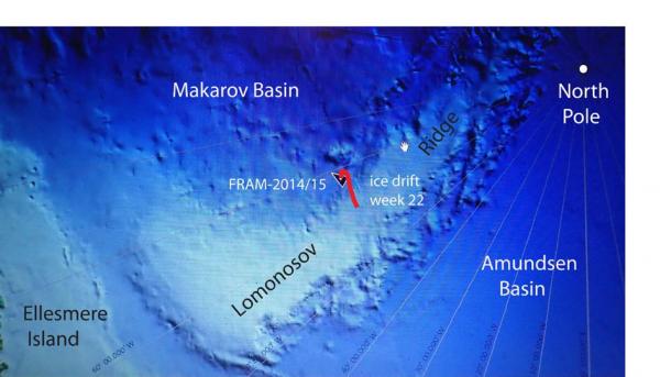
Fig. 1. The drift track (red) of FRAM-2014/15 during week 22 (26 Jan. - 02 Febr. 2015).
Sea ice dynamics
We have not noticed any evidence of ice activity in our neighborhood during the week in spite of the period of fast drift early in the week.
Camp life
The low pressure activity early in the week brought in relatively warm air and we experienced temperatures of -22° C to -24° C on Monday through Wednesday. From Thursday it became colder, the lowest being -39° C on Saturday. The period of strong winds, blowing snow and fast ice drift kept us busy up through Wednesday. On Thursday it was time to dig out equipment from the snow drifts and the rest of the week we were occupied with maintenance. We clearly made the right decision with parking the hovercraft with the front pointing northeast which turned out to be the prevailing wind direction. Snow drifts accumulate off to the sides of the craft and behind the work space (tent and snow hut). Blowing snow creeps in everywhere and one of the worries were getting the hovercraft engine room filled with snow. Fortunately, this turned out to be totally unfounded.
The one wind mill that was rescued when the camp broke up, was taken apart and checked for salt deposits. Audun mounted it on a pole on Sunday (Fig. 2), but we are not quite satisfied with the power output. We have also replaced the six 110 Ahr. batteries in the hovercraft with the new ones brought as spares, but been used heavily for other needs in the meantime. They hold the charge better and represent a considerable improvement. Also, the radiation flux instrument needs extra power to drive a fan which keeps the sensors clean. In the cold, a car battery gets flat after 2-3 days. This is now solved by supplying 12 volt directly from the hovercraft via a 50 meter cable.
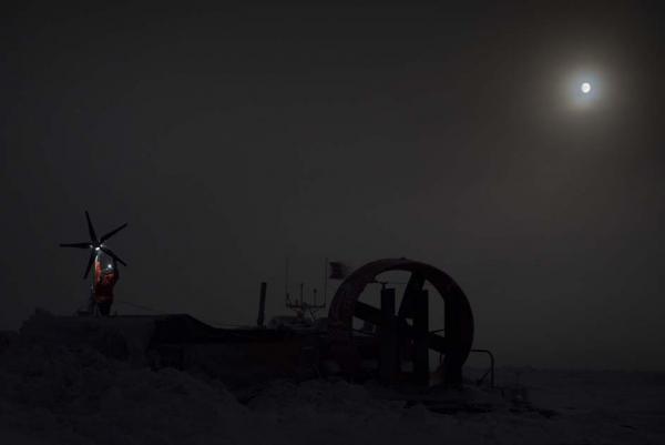
Fig. 2. Audun working on the wind mill. The work tent is in the foreground behind a snow drift.
Our hydro hole through the 1.5 m thick ice was about to freeze up and required a new effort with the vertical ice saw. In the process on Friday, we discovered that the air gun was hanging just from the air supply hose and the signal cable, an uncomfortable situation which easily could have resulted in loss of the air gun. The wire end had corroded and broken off. The air gun was recovered and seismic shooting stopped temporarily, because the ice drift was near zero from Friday through the rest of the week. On Sunday the seismic data logging PC crashed and would not reboot normally except in "Safe Mode" - we are working on the problem guided by expertise from NERSC.
On Sunday, we checked through the conductivity-temperature-depth (CTD) instrument and made it ready for deployment next week. The intent is to take CTD measurements from the surface to the bottom on a regular basis for the remaining time of ice drift.
The length of Lomonosov Ridge ( ̴1.800 km) is roughly equal to the length of Norway. We have now spent 5 months drifting over the Lomonosov Ridge and been able to get new scientific data over a section which constitutes 1/4 of the total length of the ridge. Our drift shows a pattern with periods of very slow ice drift interrupted by events of fast drift. The fast drift is forced by cells of low surface air pressure moving in to the Arctic Ocean over the Canadian Arctic Islands as lately or through the Fram Strait. As they move in, the wind direction drives the ice to the west. These events, unpredictable on a time scale of months, make it impossible to estimate with some degree of confidence where we will be when it is time for Audun to rotate off in late March/April or when we will approach the ice edge in the Fram Strait.
Science
During the week, the following suite of continuous measurements has been operating:
Bathymetry and sub-bottom profiling:
- four active autonomous echo sounder buoys reporting to shore via Iridium
- continuous seismic reflection measurements
Oceanography:
- two Aanderaa current meters at 800 and 1050 meter depth, respectively.
- 300 meter long string with temperature data loggers at 10 meter intervals suspended from the ice.
Atmosphere:
- measurement of incoming and outgoing radiation from the ice surface
- surface infrared skin temperature
- sun time
- Aanderaa weather station
The strong northeasterly winds starting on Sunday 25 January drove the ice to the west. This enabled us to obtain a seismic profile across the transition between Lomonosov Ridge and the Makarov Basin where no seismic data exists for the first quarter of the length of Lomonosov Ridge north of the Canadian Arctic. The drift track is just as straight as one would do with a ship in open water (Fig. 1). The acoustic basement of Lomonosov Ridge dips steeply ( ̴30°) into a graben more than 2 sec. (two-way travel time) or >3 km? deep (Fig. 3). Acoustic basement is formed by multiple diffractions with no clear transition between the overlying sediments and basement. We are inclined to believe that acoustic basement may constitute deformed sediments with intervals of intact dipping layers as seen in the lower right part of Fig. 3. The graben is filled with more than 3 km? of undisturbed sediments. The ridged-to-basin transition is considered to be part of the continental margin north of Svalbard-Franz Josef Land before c. 60 million years ago and the key issue is; is it a rifted or sheared margin? The new data obtained from this region which is presently inaccessible to icebreaker surveys, are going to be among the most significant scientific results obtained during the FRAM-2014/15 ice drift. There will be another opportunity for more data on the return drift towards the Fram Strait.
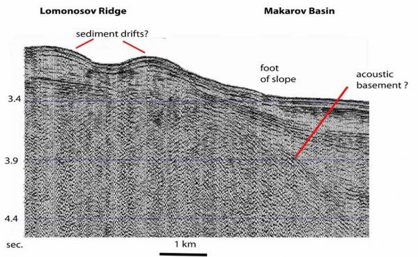
Fig. 3. Screen shot of seismic profile across the transition between the Lomonosov Ridge and the Makarov Basin (Fig. 1).
The work done to compile and update the International Bathymetric Chart of the Arctic Ocean (IBCAO) represents a fundamental prerequisite to improved understanding of the evolution, past and recent geological processes in the polar basin environment. Bathymetric maps are the starting point of any study that involves the sea bed, the sub-bottom geology and the influence of bottom topography on water mass dynamics. As we are drifting over sea bed that mostly is known from depth soundings made during helicopter landings or from drifting ice stations, bathymetry is an important component of FRAM-2014/15. We use four autonomous echo sounding buoys within a 6 km area of the camp and the seismic reflection measurements in camp to obtain more depth information. Figure 4 shows a typical example of the reality. The map suggests we were drifting over a small high, which had to imply that a small peak of hard rock had to come near the sea bed where it could be draped by sediments and form a small hill. The seismic data show a flat sea bed and no indication of any disturbing topography within the upper 1.5 km below the sea bed.
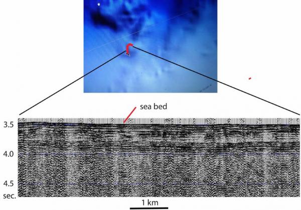
Fig. 4. Drift track over a small hill appearing on the latest version of the IBCAO-map. Below is a seismic profile which shows a flat sea bed and no disturbing basement topography in the upper 1.5 km below the sea bed.
There has been no sign of animal life in our neighborhood during the week.
Life in the High Arctic is treating us well.
Yngve Kristoffersen & Audun Tholfsen
Daily reports
Monday 26 January.
Position: 87° 07.7' N, 61° 16' W, temperature - 24° C, air pressure 1021 hPa, wind 23 knots from the NNE. Ice drift 0.3 knots towards W. Blowing snow. Shooting seismic reflection all day.
Tuesday 27 January.
Position: 87° 08.9' N, 64° 33' W, temperature - 24° C, air pressure 1017 hPa, wind 27 knots from the NE. Ice drift 0.5 knots towards W. Blowing snow. Shooting seismic reflection all day. The shot interval was 80 second at mid-day. We had to service the air gun in the early morning. Checked the radiation flux instruments, cleaned sensors and changed battery (110 Ahr. 12.8 V) for the fan.
Wednesday 28 January
Position: 87° 10.' N, 67° 28' W, temperature - 22° C, air pressure 1010 hPa, wind 33 knot from the NE. Ice drift 0.5 knots towards W. Blowing snow. Shooting seismic reflection all day. By 1400 hours, the drift slowed down and the direction turned back east towards Lomonosov Ridge. Audun worked on the wind mill taking it apart and checking for salt.
Thursday 29 January 2015
Position: 87° 08.3' N, 68° 54' W, temperature - 27° C, air pressure 1025 hPa, wind 10 knots from NE. Ice drift 0.1 knot to the E. Shooting seismic reflection all day. Cleaning up after several days of blowing snow. The wind mill came up on a pole, and the power line need to be connected
Friday 30 January.
Position: 87° 07.5' N, 68° 12' W, temperature - 31° C, air pressure 1025 hPa, wind 7 knots from the NE. Ice drift 0.1 towards E. Checked radiation flux instruments; cleaned sensors, changed fan battery (80 Ahr., 13 Volt, changed memory card and battery on the data logger. Used battery measured 12.2 Volt. Checked the weather station. Worked on cleaning the hydro hole using the vertical ice saw. Discovered the air gun hanging from the air hose and the signal cable - the wire had broken. Recovered the air gun. Insufficient wind to test the wind mill.
Saturday 31 January
Position: 87° 07.4' N, 67° 45' W, temperature - 39° C, air pressure 1029 hPa, wind 3 knots. Ice drift 0.1 knot to the east. PC for seismic data logging crashed, but came up again. Laid out 12 Volt power from the hovercraft to the radiation flux instruments to avoid maintaining batteries out in the cold.
Sunday 01 February.
Position: 87° 06.8' N, 67° 40' W, temperature -37° C, air pressure 1029 hPa, wind 10 knots from the N. Ice drift 0.1 knots towards east. Audun connected up the wind mill, but outside switch box was corroded and had to be replaced. CTD was checked and batteries changed. Replaced start batteries (2 x 110 Ahr.) and service batteries (4x 110 Ahr.) in the hovercraft. The seismic data logging PC crashed again. We are not drifting anywhere for the moment so no opportunities are lost.