
(2 - 16 Febr. 2015)
Ice drift
The ice camp moved 62 nautical miles (114 km) during these two weeks. We drifted from the Makarov Basin over the top of Lomonosov Ridge and reached the edge on the Amundsen Basin side (Fig. 1). Strong low pressure activity during the first half of February generated fast ice drift. A low pressure ridge moved up through the Fram Strait and shifted eastward to extend between Svalbard and the North Pole and later between Novaja Zemlja and the North Pole. We had a period of fast ice drift (0.5 knot) to the southeast on February 5th and during most of the second week of February. Winds were 10 to 23 knots with blowing snow.
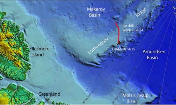
Fig. 1. The drift track (red) of FRAM-2014/15 during week 23 and 24 (02 - 16 Febr. 2015).
Sea ice dynamics
For a short while on Thursday 12 February, we heard loud sounds of ice pressuring a few hundred meters to the north of us, but have not noticed any consequences in our immediate surroundings. If anything, it is hidden by the darkness.
Camp life
Temperatures during the first week of February oscillated between -23° C and below -40° C during the first half (2-5 Febr.) and stayed below -40° C from Thursday 5th through Sunday 8th of February. In spite of this, the last part of the week was the most productive we have had in quite a while. The second week had smaller temperature variations (-24° C to -32° C). We have slowly gotten our work space into better order, but the darkness and the cold have undoubtedly had an effect on us. You develop a mental aversion towards certain tasks when the temperature falls to -40° C and below because of all cold related complications. You try to be aware of your own behavior at all times by asking: Why am I responding in this way to this particular challenge? It takes a determined effort move out of the aversion state. Once you have started the process, the profound pleasure of seeing good results coming out of your data acquisition effort creates surplus mental energy.
In spite of the darkness and the cold, our general feeling is that time flies - we often talk about that. Unfortunately, there is hardly time for yourself. Since we are only two persons, you are always haunted by a backlog of duties mostly related to preventive measures. The seismic operation is an extra challenge, because it is an around the clock duty where you do not get more than 1.5 hours sleep in between each time it is necessary to get dressed and attend to the compressor in the outside work space.
The loss of the generators temporarily diverted our attention from science and created a wake of temporary solutions for conserving electric power. The problem is recently compounded by the breakdown of both the primary and spare inverter (24 volt input, 230 volt AC output) received with the air drop. An inverter is used to power the smaller battery chargers (head lamp, seismic data logger etc.). As often there are ways to get around the problem.
Seismic data logging was moved to an identical backup system, as the primary PC failed to reboot properly at the beginning of the week. The process was guided by expert advice from PhD. Student Gaute Hope (NERSC) and senior engineer Ole Meyer (Univ. of Bergen) who both designed and implemented the total data acquisition and communication system for the hovercraft.
Engine maintenance in the cold is an important challenge. To grease a bearing is impossible as the cold grease will not move the few centimeters between your grease gun and the bearing. A heat gun would help, but we have no generator to power a heat gun.
Science
Underway continuous measurements:
Bathymetry and sub-bottom profiling:
- four active autonomous echo sounder buoys reporting to shore via Iridium
- 110 kilometer of continuous seismic reflection measurements
Oceanography:
- two Aanderaa current meters at 800 and 1050 (660) meter depth, respectively.
- 300 meter long string with temperature data loggers at 10 meter intervals suspended from the ice.
Atmosphere:
- measurement of incoming and outgoing radiation from the ice surface
- surface infrared skin temperature
- sun time
- Aanderaa weather station
Station work
- Ten CTD casts
- Three short sediment cores
- One successful deployment of the camera sled in 1.260 meter water depth. Two other attempts with partial useful footage due to light failure.
- Raised one current meter from 1050 to 660 meter depth to avoid touching bottom.
The drift this week enabled us to start a continuous seismic profile from the Makarov Basin across the Lomonosov Ridge into the Amundsen Basin. The slope facing the Makarov Basin was covered the first week and the flat top of Lomonosov Ridge during the second week. In total 110 kilometer of seismic data. The acoustic image of the basin to slope transition is similar to that shown in Fig. 3 of the report for week 22. On the upper flank, the whole 1.5 sec thick flat lying section on top of the ridge appears to be truncated at the sea bed on the slope (Fig. 2). The truncated strata may be covered with a thin sub-bottom drape. The sediments on top of the ridge are flat lying and undisturbed (Fig. 3) with a minimum thickness of 1.6 seconds ( ̴ 2.5? km). The flat top of Lomonosov Ridge is bounded to the east by a basement ridge. Unfortunately, because of the combination of fast ice drift and our crossing in the early hours on Saturday morning, we were unable to deploy the rock dredge in time for this target.
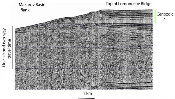
Fig. 2. Screen shot from the seismic monitor record drifting over the edge of Lomonosov Ridge.
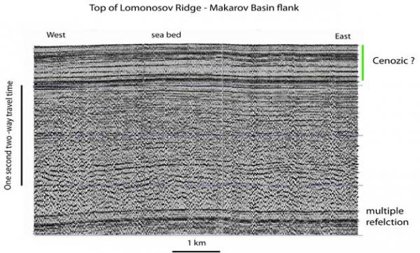
Fig. 3 Screen shot of the seismic monitor where the ice station is over the top of Lomonsov Ridge.
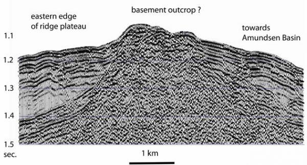
Fig. 4 Screen shot of the seismic monitor when the ice drift is over the eastern edge of the flat area on top of Lomonosov Ridge.
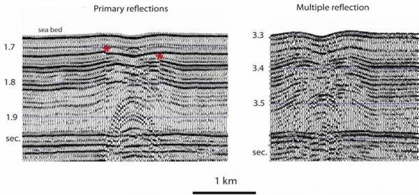
Fig. 5 Screen shot of the seismic monitor showing a peculiar acoustic image within the upper 0.3 sec. (300 meter) of the sea bed. Asterisks indicate an offset artifact from changes in the pulse form as a result of increase (10-20 bars) in operating air pressure to nominal 140 bars every time the compressor is run to replenish the air reservoir.
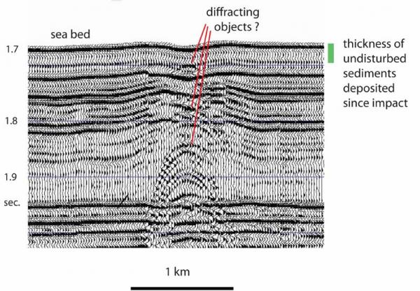
Fig. 6 Our preliminary interpretation of the acoustic image as sediment deformation due to impact of an object on the sea bed. The diffraction points may be possible fragments of the object.
We came across a very mysterious perturbation of the flat-lying undisturbed seismic sequence on the top of Lomonosov Ridge (Fig. 5). The water depth is 1.260 meter. A small depression is flanked by symmetric elevated rims and extends over a depth range of about 150 meter Point diffractors are present at several levels at the center of the structure. A similar feature is observed about 5 km farther east. The limited depth extent and the symmetry suggest the disturbance may be due to forces excerted from above into an undisturbed sea bed. The disturbed section appears to be covered by a ̴0.02 sec. (20 meter) thick sediment drape.
We welcome alternative interpretations of the observations in Figs. 5 and 6. Our working hypothesis is that the sea bed has been disturbed by an object which fell into the Arctic Ocean and created a 3-400 meter wide "crater" in the sea bed and the underlying stratigraphy to 150 meter sub-bottom (Fig. 6). The overlying ̴ 20 meter thick sediment drape suggests this event occurred on the order of 2 million years ago. The observation of two small possible impact structures on Lomonosov Ridge is a remarkable parallel to our observation of a 200 km x 600 km area of disturbed sea bed sediments on the Alpha Ridge about 450 km to the west (see attached publication). On the Alpha Ridge, massive submarine slides have been triggered, in places more than 1oo meters of sediments have been "blown away" and near bottom sediments have been deformed. All this is now covered by a 20-25 meter thick sediment drape. Our interpretation of the observations from Alpha Ridge was that fragments of an asteroid hit the Arctic Ocean about 2 million years ago and created a pressure wave which heavily disturbed the sea bed in the area of impact. So far there is no evidence of one or more craters. We suggest that the events on Alpha Ridge and Lomonsov Ridge could be related. To the best of our knowledge, there is so far no known direct evidence of impact craters in the deep global ocean. The Eltanin impact in the SE Pacific in about 4.000 meter water depth is manifested by disturbed sediments.
We started our vertical profiling of conductivity (salinity), temperature and depth (CTD) from surface to the bottom in the Makarov Basin as the drift direction again turned towards Lomonosov Ridge. The instrument is a self contained Sea Bird V19plus (Fig. 7). Casts were done each day and the separation varied between 13.5 and 5 km. This data will add to the inventory of oceanographic measurements used to characterize water masses, temporal changes in temperature and to carry out calculations of the geostrophic currents needed to maintain the dynamic balance.
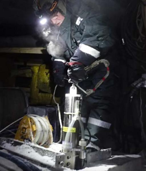
Fig. 7 Preparing the CTD to be lowered through the hydro hole
Three short sediment cores were obtained from the top of Lomonosov Ridge for the Ice2Ice project of several Nordic centers of excellence. The Ice2 Ice project seek to document the extent of sea ice in the Arctic Ocean during warm climate periods and to investigate its relation to the state of the Greenland Ice Sheet..
We deployed the camera sled in 1.260 meter water depth and obtained about 30 minutes of HD video recording of life forms at the sea bed. This includes another glimpse of a half meter long bluish fish. Some of the footage is attached to this report. Unfortunately, the underwater lights are giving us problems and the intensity of one of the lights is reduced. We had two more deployments that were only partly successful due to light failure as well as the camera sled getting dragged sideways.
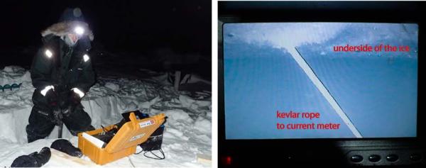
Fig. 8. From our effort to raise the current meter. Watching the underwater camera (left) and the picture on the screen showing the Kevlar rope having an angle at about 45 degrees instead of being vertical.
The ice drift was heading for an area of the Lomonosov Ridge which would be shallower than 800 meter. On Wednesday 11 February we managed to raise one of the current meters to 660 meter depth. This instrument was initially suspended at 2.000 meter and later raised to 1.050 meter. The next day, we started work on the mooring for the instrument that has been at 800 meter depth since September 2014. It is now only 5 meter away from a substantial pressure ridge which clearly spells trouble. We were unable to hook on to the Kevlar line under the ice. With the help of an underwater camera, we discovered the line had an angle away from the pressure ridge (Fig. 8). This indicates that the neighboring ice floe has been pushed under the site of the current meter and diverted the line. There are now two layers of ice separated by a water layer. It may still be possible to rescue the instrument, but it will take a lot of work. The task has been postponed until late spring/early summer
We have started to see indication of light on the horizon to the south at noon.
There has been no sign of animal life in our neighborhood during the week.
Life in the High Arctic is treating us well.
Yngve Kristoffersen & Audun Tholfsen
Daily reports
Monday 02 February.
Position: 87° 06.0' N, 67° 48' W, temperature - 28° C, air pressure 1027 hPa, wind 10 knots from the N. Ice drift 0.0 knot. Seismic acquisition PC is down - we are working on the problem. Audun moved fuel towards the camp from a temporary fuel bladder location. Sent an invitation to Dr. Artur Chilingarov for a Russian polar scientist/technician to replace Audun at crew change.
Tuesday 03 February.
Position: 87° 05.9' N, 67° 47' W, temperature below - 40° C, air pressure 1017 hPa, wind 5 knots from the N. Ice drift 0.0 knot. PC completed 15 hour disk scan/repair cycle. Reboots in Windows as usual, but flips back to fault conditions. Checked the radiation flux instruments and cleaned sensors. Made the first CTD cast down to 2.450 meter in 2560 meter water depth
Wednesday 04 February
Position: 87° 04.0' N, 67° 47' W, temperature - 23° C, air pressure 981 hPa, wind 10 knot from the N. Ice drift 0.2 knots towards E. Moved seismic acquisition to back-up PC which has an identical set-up. Restarted seismic shooting at 1245 hours. Checked radiation flux instrument and cleaned sensors. Made another CTD cast down to 2.400 meter depth - water depth is 2.550 meter. Audun moved 1.000 liter diesel up to the hovercraft.
Thursday 05 February 2015
Position: 87° 03.8' N, 65° 28' W, temperature - 36° C, air pressure 990 hPa, wind 15 knots from the S. Ice drift 0.4 knot to the E. Shooting seismic reflection all day. Made a CTD cast. On the way up, the CTD remained at 600 meter depth for one hour because a hydraulic hose burst and had to be replaced. Reamed the hydro hole.
Friday 06 February.
Position: 87° 05.6' N, 63° 23' W, temperature below - 40° C, air pressure 997 hPa, wind 17 knots from the S. Ice drift 0.2 towards ENE. Shooting seismic reflection all day. The camera sled was deployed in 1.260 m water depth. About 30 minutes of video recorded with the sled in motion and several life forms imaged which we have not seen at our earlier deployments. A CTD cast made to 1180 meter depth.
Saturday 07 February
Position: 87° 06.5' N, 62° 32' W, temperature below - 40° C, air pressure 1005 hPa, wind 4 knots from the N. Ice drift 0.1 knot to the SE. Shooting seismic reflection all day. Deployed the short sediment corer and recovered a 20 cm core for the Ice2Ice-project.
Sunday 08 February.
Position: 87° 05.8' N, 62° 10' W, temperature below -40° C, air pressure 999 hPa, wind 6 knots. Ice drift 0.1 knots towards east. Shooting seismic reflection all day. Made a CTD
cast to 1.130 meter - water depth is 1.250 meter. Adapted more lead weight to the short corer, and we moved the Kevlar drum from the cold work space into the heated tent.
Monday 09 February.
Position: 87° 04.0' N, 61° 33' W, temperature - 32° C, air pressure 994 hPa, wind 8 knots Ice drift 0.2 knot towards SE. Shooting seismic reflection all day. Checked the radiation flux sensors, the fan works fine. Recovered one sediment core (60 cm) in 1.260 meter water depth and made one CTD cast down to 1.100 meter depth.
Tuesday 10 February.
Position: 86° 59.8' N, 60° 33' W, temperature -32° C, air pressure 990 hPa, wind 16 knots from the NW. Ice drift 0.3 knot towards SE. Shooting seismic reflection all day. Deployed the camera sled in 1.150 meter water depth. The camera lights went to blinking mode at the bottom and made the run less useful. Made CTD cast down to 1.080 meter depth.
Wednesday 11 February
Position: 86° 57.2' N, 58° 57' W, temperature - 29° C, air pressure 990 hPa, wind 14 knot from WSW. Ice drift 0.4 knots towards SE. Shooting seismic reflection all day. Raised one current meter from 1.050 meter depth to 660 meter by drilling a hole and snagging the Kevlar line with a hook. Pulled the Kevlar through a pipe filled with ethanol to facilitate an easy new adjustment of the depth once we are off the ridge.
Thursday 12 February 2015
Position: 86° 53.5' N, 57° 08' W, temperature - 24° C, air pressure |003 hPa, wind 11 knots from the W. Ice drift 0.3 knot to the SE. Shooting seismic reflection all day. Started work to raise the second current meter from 800 meter depth. The location is now 5 meter from a pressure ridge. Using the underwater camera, we saw the Kevlar line diverted away from the pressure ridge. To recover the instrument require drilling holes to follow the line until we reach the end of the under thrusted ice floe. This work has to be deferred until late spring/early sommer.
Friday 13 February.
Position: 86° 46.7' N, 54° 51' W, temperature -32° C, air pressure 1001 hPa, wind 23 knots from the W. Ice drift 0.4 towards SE. Shooting seismic reflection all day. A snow storm outside makes problems to get inside the outer work space. Made one CTD cast in the early hours to 750 meter depth and another cast late at night to 850 meter depth. We also made two attempts to obtain a short sediment core, but the corer had no penetration and came up empty
Saturday 14 February
Position: 86° 43.3' N, 52° 43' W, temperature - 30° C, air pressure 1005 hPa, wind 9 knots from the W. Ice drift 0.3 knot to the E. Shooting seismic reflection all day. We missed out on deploying the rock dredge over a basement exposure on the sea bed. Worked all day to improve the hydro hole which was about to
be closed by new ice. Made a CTD cast in the evening and deployed the camera sled. Upon recovery, the video footage showed the camera lights had gone into blinking mode and also the sled had been dragged sideways.
Sunday 15 February.
Position: 86° 43.2' N, 52° 00' W, temperature -36° C, air pressure 1015 hPa, wind 6 knots from the E. Ice drift 0.0 knot. Shooting seismic reflection all day. Checked out the radiation flux instrument and cleared the IR sensors for snow. Deployed the sediment corer in the early hours and obtained a 38 cm core for the Ice2Ice project. Audun went for a ski trip in the neighborhood. If the drift speed holds up, we are about to enter the 200 nautical mile zone north of Greenland in a day or so.