
(16 - 23 Febr. 2015)
Ice drift
The ice camp moved 40 nautical miles (74 km) during the week. The drift was over the slope of Lomonosov Ridge into the Amundsen Basin (Fig. 1). The surface air pressure has had a steady pattern with a regional low pressure in the sector between Greenland and Severnaya Zemlja and a high pressure region between the Beaufort Sea and the East Siberian. The result has been prevailing northerly winds at our location and steady ice drift towards southeast. The drift speed has been 0.2-0.3 knot with a maximum of 0.4 knot early Saturday 21 February.
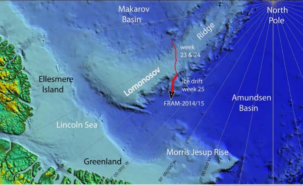
Fig. 1. The drift track (thick red) of FRAM-2014/15 during week 25 (16 - 23 Febr. 2015).
Sea ice dynamics
On Wednesday evening, we discovered a thin crack running parallel to the hovercraft about 3 meter away. The trace went under a fuel bladder and the diesel was immediately pumped over to the hovercraft fuel tank. No further motion has taken place.
Camp life
On Monday 16 February the temperature was -40° C, and varied between -26° C and -33° C later in the week. The week has been fairly productive scientifically, but our electric power challenge took another turn on Thursday when the wind mill stopped after two weeks of operation. In winds above 16 knots, it delivered enough power to break even with our consumption. Upon inspection of the brand new mill, we found the shaft bearing was intermittently locking the motion. With no spare ball bearing of the correct size available, the wind mill is no longer functional. The fate or our initially diverse options for electric power defies our imagination during planning of this expedition. We considered two 4.5 kW diesel generators, two small gasoline generators (0.8 and 1.2 kW) and two wind mills (1 kW) to be a sufficient safety margin. Both diesel generators have suffered the same fatal mechanical failure after over 3.000 hours and 2 hours, respectively. One gasoline generator and one wind mill was lost in the ice when the camp broke up in October, and the last wind mill is now out. The only item left is the 800 W generator which does not hold a load. Although this may sound dramatic, the problem is solved by temporarily including our auxiliary batteries which need to be charged into the battery bank of the hovercraft engine. The result is no more time wasted on temporary solutions.
We are drifting over the lower slope of Lomonosov Ridge into the Amundsen Basin. As the ridge is now behind us, we feel the pressure is off for a couple of weeks until we get over the next submarine feature, the Morris Jessup Rise north of Greenland presumably in late March (Fig. 1). Staying alert and ready to exploit any scientific opportunity on the sea bed presented by the seismic data on the screen, put pressure on you day and night throughout the week. There is always a trade-off between science and logistic priorities. Camp maintenance had to become second priority for a while in spite of our awareness of the accumulated effect of recurrent periods of blowing snow during week after week. We have been parked in one place since early December and blessed with no interference from ice activity, but at a price. An over 2 meter thick snow drift has accumulated on the upwind side of our work space on the port side of the hovercraft and is as high as the roof (Fig. 2). Elsewhere the additional snow depth around the hovercraft is about 0.5 meter. The priority now is to make the preparations needed for relocation if desired or needed. Another task on the waiting list is relocating the 8 drums of Jet-A1 fuel from the old camp area. They were stored near the old ice hangar and in the zone which suffered from invasion of over water on the ice. As a result, the lower 20 centimeter of each drum is frozen into the ice.

Fig. 2. The hovercraft and work space on 5 January (left) and 22 February (right).
Science
Underway continuous measurements:
Bathymetry and sub-bottom profiling:
- 74 kilometer of continuous seismic reflection measurements
- four active autonomous echo sounder buoys reporting to shore via Iridium
Oceanography:
- two Aanderaa current meters at 800 and temporarily at 660 meter depth, respectively.
- 300 meter long string with temperature data loggers at 10 meter intervals suspended from the ice.
Atmosphere:
- measurement of incoming and outgoing radiation from the ice surface
- surface infrared skin temperature
- sun time
- Aanderaa weather station
Station work
- Four CTD casts
- Two camera sled deployments (2.280 and 2080 meter water depth)
- One unsuccessful sediment coring attempt.
Another 74 km of seismic reflection data has been added to a continuous seismic profile from the Makarov Basin across the Lomonosov Ridge into the Amundsen Basin (Fig. 1). The total length of this transect is now 184 km. It is our intent to continue the seismic data acquisition over this unsurveyed southern part of Amundsen Basin until we pass the Morris Jesup Rise.
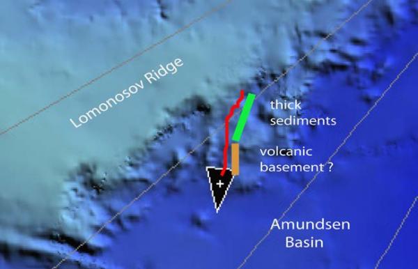
Fig. 3. Generalized sub-bottom geology along the drift track. For location, see Fig. 1
The upper slope of Lomonosov Ridge is underlain by thick sediments which is onlapping a basement domain of possible volcanic origin from the mid-slope and deeper (Fig. 3). This was all surprising, since the oldest magnetic isochrones in the Amundsen Basin indicate there is space in this area which may be occupied with continental crust of a collapsed margin.
The prevailing wind pattern has shifted from northeast to west and we have been concerned about the ambient noise level when the hovercraft engine was running. We moved the hydrophone site to the upwind side and got much better results.
Our intent was to take CTD casts at regular intervals for the remainder of the drift. We have completed a transect of 14 CTD casts across Lomonosov Ridge, but are getting increasingly concerned about our fuel situation. Each cast takes about 3 hours of engine time which also contributes to charging batteries. However, we need to have three stoves going; two in the hovercraft and one for the compressor, plus a forth stove in the work space as needed. In addition, we need to run the engine for about 20 minutes every one and a half hour to replenish charge level on the hovercraft service batteries which power the data logging systems. All in all it amounts to over 50% higher than expected consumption. For this reason, we postpone further CTD work until we have established how much of the Jet-A1 fuel we have to contribute to a crew change.
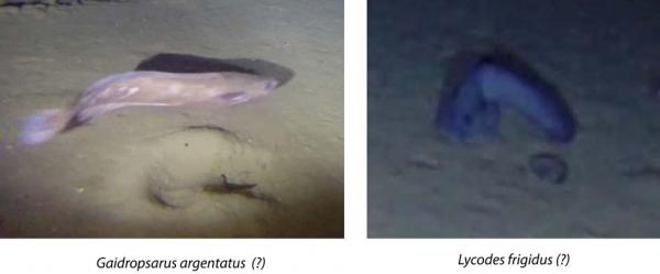
Fig. 4. Pictures of fish species imaged by the bottom camera sled on Lomonosov Ridge. The occurrences are shown in Fig. 5.
We observed fish in both camera sled deployments this week. The video clips submitted as attachments to earlier reports have been looked at by a number of experts. Randi Ingvaldsen of the Institute of Marine Research, Bergen has kindly collected information from Russian and Norwegian colleagues. The consensus is that the grey fish species is most likely a Gaidropsarus argentatus (Norw.; Sølvtangbrosme). This species have been recovered by trawl north of Svalbard. The darker fish is probably a Lycodes frigidus (Norw.; arktisk ålebrosme). The Arctic Biodiversity Assessment report (http:/www.arcticbiodiversity.is/the-report/chapters/fishes) lists thirteen species of fish found in the Arctic Central Basin, but the Gaidropsarus argentatus is not included. Our observations may be the first documentation of its presence in the deep basin.
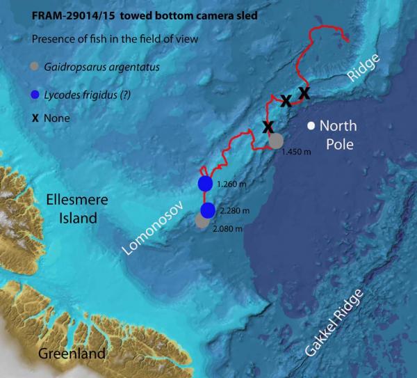
Fig. 5. Locations of sightings of fish in the field of view of the bottom camera sled.
The sun is now about 9 degrees below the horizon at noon and one may walk outside without the need of a head lamp.
There has been no sign of animal life in our neighborhood during the week.
Life in the High Arctic is treating us well.
Yngve Kristoffersen & Audun Tholfsen
Daily reports
Monday 16 February.
Position: 86° 42.3' N, 51° 47' W, temperature - 40° C, air pressure 1018 hPa, wind 4 knots from the NW. Ice drift 0.1 knot to the south. Shooting seismic reflection all day. We are at the edge of the flat-topped ridge, water depth 1500 meter. Made a CTD cast down to 1450 meter at 1445 hours and another cast at 2300 hours to 2000 meter in 2080 meter water depth.
Tuesday 17 February.
Position: 86° 40.7' N, 51° 20' W, temperature - 33° C, air pressure 1012 hPa, wind 8 knots from the NW. Ice drift 0.2 knot towards SE. Shooting seismic reflection all day. Deployed the camera sled in 2.280 meter water depth. Unfortunately, the Kevlar laid out on the bottom had hooked on to the sled and pulled it sideways. Made a CTD cast down to 2.100 meter water depth. Also deployed the short sediment corer - had 0.6 meter penetration, but the core barrel came up empty.
Wednesday 18 February
Position: 86° 37.2' N, 50° 28' W, temperature - 26° C, air pressure 1005 hPa, wind 11 knot from the NW. Ice drift 0.2 knots towards SE. Shooting seismic reflection all day. CTD cast down to 2.400 meter in 2.500 meter water depth. Each run takes about 3 hours with the hovercraft engine running. We have to conserve fuel and will stop making CTD casts from now on. We have obtained a transect with 13 casts over the Lomonosov Ridge. Blowing snow in the evening. Audun discovered a small crack running parallel to the hovercraft about 3 meters away. The crack went under one of the fuel bladders and the fuel was immediately pumped over to the hovercraft.
Thursday 19 February 2015
Position: 86° 32.2' N, 50° 11' W, temperature - 33° C, air pressure 1013 hPa, wind 10 knots from the N. Ice drift 0.2 knot to the SE. Shooting seismic reflection all day. Our internal WiFi-network which distributes the GPS-signal to the different logging systems was down for about one hour. Audun continued exploring our small 800 W generator which will take a heavy load such as the grinder (600 W) , but not a small load such as battery chargers. The key is adjustment of the revolutions pr. minute. Also the wind mill stopped, the problem being the shaft ball bearing gets locked.
Friday 20 February.
Position: 86° 29.8' N, 49° 39' W, temperature - 32° C, air pressure 1015 hPa, wind 12 knots from the W. Ice drift 0.3 towards SE. Shooting seismic reflection all day. Deployed the camera sled in 2.080 meter water depth. Another observation of a fish.
Saturday 21 February
Position: 86° 23.5' N, 47° 54' W, temperature - 27° C, air pressure 1009 hPa, wind 16 knots from the W. Ice drift 0.4 knot to the SE. Shooting seismic reflection all day. Continued testing the small 800 W generator. Started preparations for
jacking up the hovercraft to get out of the snow drift. The hovercraft has been sitting on two 2" x 2" planks since beginning of December and held up very well. This is in strong contrast to what we experienced in September and October where the keel was constantly sinking in the relatively warm ice. However, on the outside about 0.5 meter of snow has by now accumulated on the starbord side and 1.5 meter on the port side.
Sunday 22 February.
Position: 86° 18.2' N, 46° 33' W, temperature -29° C, air pressure 1003 hPa, wind 9 knots from NW. Ice drift 0.3 knots towards SE. Shooting seismic reflection all day. Started jacking up the hovercraft to free it from the snow. To get it free will be a major job which from now on will have first priority.