
(2 - 9 March 2015)
Ice drift
The difference between the locations of the ice camp at the beginning and end of the week was 1.5 nautical mile (2.7 km). However the zig-zag in between amounts to 14 km. All in all, the most extreme drift we have experienced so far. Winds have been less than 7 knots all week and mostly from the northwest. The drift direction has shifted back and forth between SE and W - in the latter case against the wind direction. Surface air pressure has maintained a high pressure ridge between the Canadian Arctic islands and the New Siberian islands through Wednesday. On Thursday, our area was under the influence of a low pressure north of Canada, and from Friday a low pressure heading north through the Fram Strait. On Sunday afternoon, southerly winds generated by the low pressure finally set the ice in motion and the drift was 0.3 knots. Since we hardly moved during the whole week, we include results obtained Monday 9th and Tuesday the 10th of March in this report.
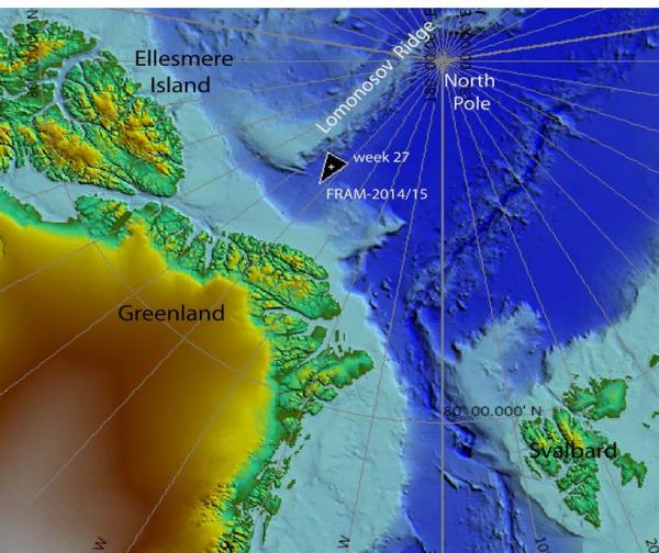
Fig. 1. The position of FRAM-2014/15 10 March 2015. The drift 02 March - 9 March 2015 is too small to be visible at this scale..
Sea ice dynamics
A friendly thin crack was discovered on Sunday about 55 meter from the craft and separates the thermistor string from the rest of the camp. It runs 8 meter from the thermistor string and 20 meter from the radiation-flux instruments.
Camp life
Except for a mild Friday March 6th (-22° C), temperatures this week ranged between - 27° C and - 40° C. Our main activity this week has been camp logistics and hovercraft maintenance. We have now broken loose all ten drums of fuel that been frozen into the ice (20 cm) by water that flooded the ice at the time our ice hangar had to be abandoned last October (Fig. 2). This fuel will now be used for heating during the remainder of the drift. We also finished off our hovercraft site project by putting a tarp under the rear part of the hovercraft to seal off air leakage in case we have to lift off and move. However, any attempt to move will be a major challenge because of the snow accumulation around us - we will deal with that when the time comes (Fig. 3). The opportunity presented by the warm weather on Friday was used for engine maintenance. A tarp over the engine bay and a propane heater inside made reasonable working conditions for readjusting the lift fan drive belt which is an awkward job due to difficult access. We could grease all points and also change the fuel filters. The 440 H.p. Deutz engine has performed extremely well to our expectations and started on the first turn at all times in temperatures below - 40° C. We passed 2.000 engine hours on Monday and about 500 hours is spent on this trip.
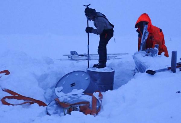
Fig. 2. Breaking loose the frozen in fuel drums at the old camp site
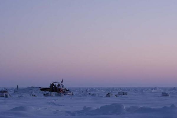
Fig. 3. The FRAM-2014/15 camp site. Note the amount of snow on the left side of the hovercraft.
So far, we have made three attempts on skis and by foot to search for the nearest autonomous bathymetry buoy which should be about 500 meters from the old camp, but with no success. On Sunday, Audun made a 2.5 hour ski trip to look for the second nearest buoy and found it 1.7 km away north of our present camp (Fig. 4). We are communicating with Woods Hole Oceanographic Institution, USA on how to trouble shoot and get it back in operation.
Fig. 4 Instrument case of one of the autonomous bathymetry buoys.
Science
Underway continuous measurements:
Bathymetry and sub-bottom profiling:
- 14 kilometer of continuous seismic reflection measurements
- four active autonomous echo sounder buoys reporting to shore via Iridium
Oceanography:
- two Aanderaa current meters at 800 and 2.000 meter depth, respectively.
- 300 meter long string with temperature data loggers at 10 meter intervals suspended from the ice.
Atmosphere:
- measurement of incoming and outgoing radiation from the ice surface
- surface infrared skin temperature
- sun time
- Aanderaa weather station
Station work
None.
The water depth is about 3.300 meter and beyond the length of our available kevlar line (2.800 meter). The CTD work has been suspended in order to ease our fuel situation.
The drift track during the week was a tight zig-zag at the foot of slope, but the distance covered represented nevertheless 14 km of seismic reflection data. The big change came Sunday afternoon and through Monday 9th and Tuesday 10 March as we started drifting south at 0.3 knots. We had anxiously been waiting for this moment for almost two weeks. We expected to pass over a feature on the seabed of major geological significance (Fig. 5). but yet unexplored and not present on any editions of the International Bathymetric Chart of the Arctic Ocean (Fig. 6). Our camp drifted over a submarine channel, almost 300 meter deep with an apparent width of 5 kilometer (Fig. 5). For insiders, this dimension is comparable to the width of Manhattan Island, New York (3.7 km) or the inner Oslo Fjord at the latitude of Nesodden (4.6 km). This is the largest deep sea channel in the Arctic Ocean known at present. We published on the issue in Marine Geology in 2004 and also submitted a formal application for naming it the NP-28 Channel in recognition of the contributions to Arctic marine geo-exploration made by the Soviet ice drift station NP-28. The NP-28 seismic data presented the first evidence for the existence and dimensions of the channel. The absence of this large submarine feature in any bathymetric maps is most likely explained by the simple fact that mapmakers can only portray on a map what is justified by the bathymetric data base. We need to contribute the available data to rectify this deficit.
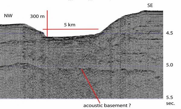
Fig. 5. Screen shot of the seismic section across the channel. Apparent width is 5 km, but true width is more like 3.5 km.
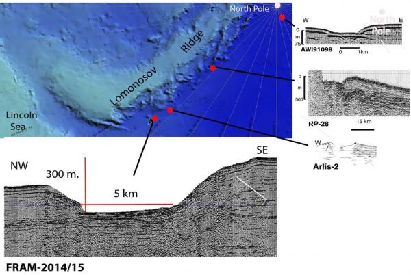
Fig. 6. Compilation of available seismic data documenting the presence of the NP-28 Channel.
We interpret the NP-28 Channel to have been the major pathway for sediment transport to the southwestern part of the deep Amundsen Basin. The sediments have most likely been supplied by glacial advances over the Lincoln Sea continental shelf and mass wasting on the continental slope funneled into a channel at the foot of the rising topography of the Lomonosov Ridge. With time a submarine fan evolved to comprise a major part of the deep Amundsen Basin north of Greenland (Fig. 7).
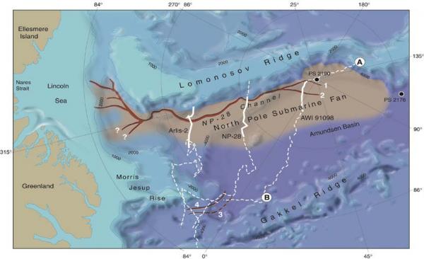
Fig. 7 Outline of the trajectory of the NP-28 Channel, its suggested sediment source area on the Lincoln Sea continental slope and relation to the deposition of a large submarine fan in the Amundsen Basin. From Kristoffersen et al., Marine Geology, 2004
In the last report we mentioned that one of the current meters had been lowered back to its full depth (2.000 m). A picture from this operation was inadvertently left out and is shown here in Fig. 8.
Fig. 8. Lowering the current meter back from 660 meter depth to 2.000 meter.
There has been no sign of animal life in our neighborhood during the week.
Despite the cold, life in the High Arctic is treating us well.
Yngve Kristoffersen & Audun Tholfsen

At noon March 5th 2015. A walk in the polar desert looking for an autonomous bathymetry buoy.
Daily reports
Monday 02 March.
Position: 86° 07.6' N, 45° 05' W, temperature - 33° C, air pressure 1018 hPa, wind 9 knots from the NW. Ice drift 0.1 knot to the W. Shooting seismic reflection until 1200 hours. Hauled a drum of Jet A1 fuel from the old camp to the hovercraft to use for the stoves.
Tuesday 03 March.
Position: 86° 07.6' N, 45° 20' W, temperature -30° C, air pressure 1018 hPa, wind 3 knots from the NW. Ice drift 0.1 knot towards W. Shooting seismic reflection all day. Checked the radiation flux instruments and cleaned sensors. Have included the battery for the fan into the battery bank for the main engine to secure charging.
Wednesday 04 March
Position: 86° 07.5' N, 45° 29' W, temperature - 31° C, air pressure 1013 hPa, wind 7 knot from the NW. Ice drift 0.1 knots towards W. Operating the seismic reflection gear, but little or no ice drift. Freed two more drums of Jet-A1 from the ice in the old camp. Have received 5 cm of snow today.
Thursday 05 March
Position: 86° 07.6' N, 45° 16' W, temperature - 40° C, air pressure 1000 hPa, wind 1 knots from the N. Ice drift 0.1 knot to the W. Shooting seismic reflection, but little or no ice drift. Went to the old camp and broke loose the last 5 drums of Jet-A1 fuel from the ice. Took a 1.5 hour search for the bathymetry buoy nearest camp (500 m) , but did not find anything.
Friday 06 March
Position: 86° 07.3' N, 45° 16' W, temperature - 22° C, air pressure 994 hPa, wind 3 knots from the NW. Ice drift 0.1 towards SE. A most welcomed "hot" day and opportunity for engine maintenance. Put a tarp over the engine bay and used the propane burner for heating. Adjusted the lift fan belt tension, greased all points and changed diesel fuel filters. We have lately been unable to get the engine to run over 1000 rpm, which turned out to be clogged fuel filters for the second time on the ice.
Saturday 07 March
Position: 86° 06.9' N, 45° 08' W, temperature - 29° C, air pressure 994 hPa, wind 2 knots from the NW. Ice drift 0.1 knot to the W. Shooting seismic reflection all day, but almost no ice drift. Checked radiation flux instruments and weather station and removed frost. Audun went for a 2.5 hour ski trip and located bathymetry buoy # 2 at 1.7 km away in the direction of 044 degrees. Reported to Woods Hole Oceanographic Institution.
Sunday 08 March.
Position: 86° 06.5' N, 44° 58' W, temperature - 29° C, air pressure 993 hPa, wind 6 knots from the W. Ice drift 0.2 knot towards E. Shooting seismic reflection all day.
Checked radiation flux instruments and the weather station for snow on sensors. Audun moved 1000 liter of our remaining fuel some of the way from the old camp towards the hovercraft. White out and light snow in the morning and light blowing snow towards the evening. A friendly thin crack was discovered about 55 meter from the craft and separates the thermistor string from the rest of the camp. It runs 8 meter from the thermistor string and 20 meter from the radiation-flux instruments.