
(9 - 16 March 2015)
Ice drift
The FRAM-2014/15 ice camp drifted 32 nautical miles (60 km) during the week (Fig. 1). The ice was driven by winds (12-16 knots) from the north due to a low pressure that moved north from the Norwegian-Greenland Sea. The center was over Svalbard at the start of the week (9th March) and later moved east (Fig. 2). The ice drift was 0.3 knots up until Thursday 12th March and then slowed down to less than 0.1 knots.
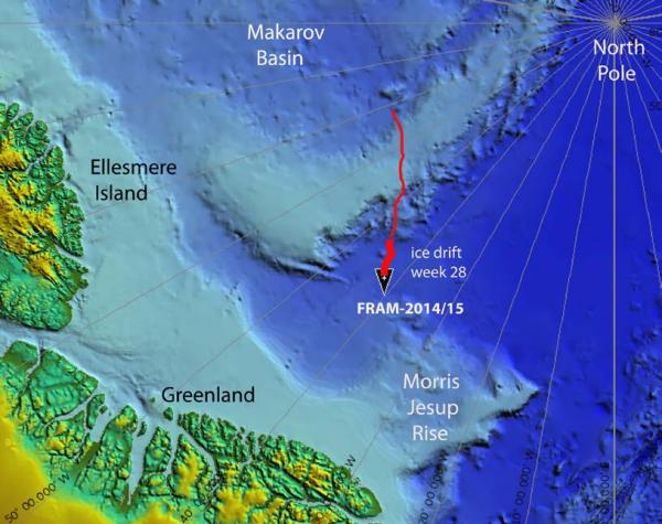
Fig. 1. The drift of FRAM-2014/15 during week 28, 09 - 16 March 2015 (heavy red line). Thin red line indicates start of 570 km long seismic transect from the Makarov Basin to the Morris Jesup Rise.
Low pressure systems moving into the Arctic Ocean have profound effect on ice motion. The direction of the wind associated with a low pressure cell is anti-clockwise and roughly parallel to the contours pointing slightly towards the center. The closer the contours of equal pressure (isobars)
around the center are together, the stronger the wind. A low cell pressure moved north from the Norwegian-Greenland Sea towards Svalbard on March 8th and then east towards Franz Josef Land and the New Siberian Islands (Fig. 2). The effect was persistent strong winds from the north in the area north of Greenland. The wind field effectively accelerated the sea ice transport out of the Arctic Ocean into the Fram Strait over the whole area to the south of the position of the FRAM-2014/15 ice camp (Fig. 3). The message for us is that as we drift south, we are likely to experience the effect of similar low pressure trajectories and a more dynamic ice situation than we have had so far this year.
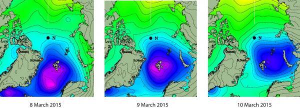
Fig. 2 Maps of air pressure at sea level from www.dmi.dk showing the motion of a low pressure cell during the first part of week 28. This situation gave persistent winds from the north towards the Fram Strait between Svalbard and Greenland.
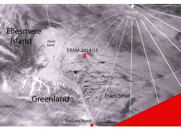
Fig. 3 Satellite image courtesy of www.woksat.info for the area north of Greenland. Note region of broken up large units south of the position of the FRAM-2014/15 ice camp
Sea ice dynamics
The friendly thin crack discovered a week ago about 55 meter from the hovercraft separating the thermistor string from the rest of the camp, widened to about 3 meter and later narrowed to about 2 meter on Sunday. It runs 8 meter from the thermistor string and 20 meter from the radiation-flux instruments.
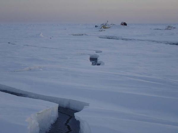
Fig. 4 Friendly cracks in our neighborhood and the camp in the background.
Camp life
Air temperatures varied little during the week; - 21° C to - 26° C during the first four days and between - 29° C and - 31° C at the end of the week.
Work this week has mainly been keeping the seismic data acquisition and other instruments going. The effect of the unfortunate loss of the generators is becoming more and more apparent. Instead of a 5 horsepower generator, we have had to run the 440 horsepower main engine 5 hours pr. day for 2.5 months now to charge batteries. The consequence for our fuel supply is becoming a serious concern. If we do not get access to a generator in the near future, we will have to cut data acquisition for all systems that requires power from the hovercraft,
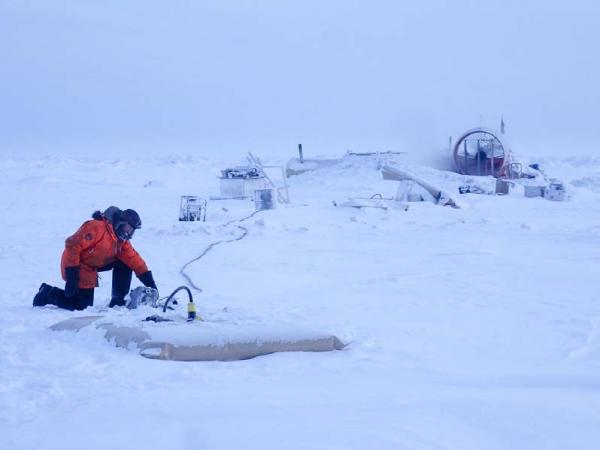
Fig. 5. Fuel is contained in 1.000 liter fuel bladders and moved by pumping.
Removing snow is a never ending project. Passing centers of low air pressure is associated with winds and good ice drift towards the Fram Strait, but also with falling snow which collects into drifts.
The return of the light was a big change and brings back a feeling of more energy. Our first priority was to assess the surrounding ice landscape. Our floe or flat area is about 200 x 400 meter and appears like a reasonable place to be. The prevailing scenery in our neighborhood is one with ice blocks scattered around everywhere and in general not particularly friendly for hovercraft driving.
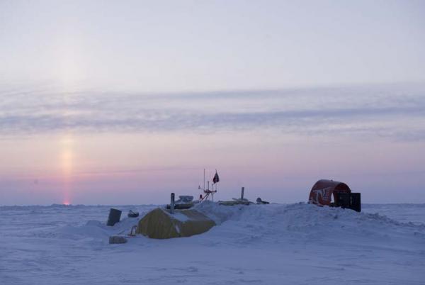
Fig. 6 The first glimpse of the sun
Science
Underway continuous measurements:
Bathymetry and sub-bottom profiling:
- 60 kilometer of continuous seismic reflection measurements
- four autonomous echo sounder buoys reporting to shore via Iridium
Oceanography:
- two Aanderaa current meters at 800 and 2.000 meter depth, respectively.
- 300 meter long string with temperature data loggers at 10 meter intervals suspended from the ice.
Atmosphere:
- measurement of incoming and outgoing radiation from the ice surface
- surface infrared skin temperature
- sun time
- Aanderaa weather station
Station work
None.
The water depth is about 3.300 meter and beyond the length of our available kevlar line (2.800 meter).
The seismic data acquisition is going very well. We have now completed the first half of an over 500 km long seismic profile which hopefully will extend from the Makarov Basin in the NW to across Morris Jesup Rise in the SE (Fig. 1).
About 20 km into Amundsen Basin from the foot of slope of the Lomonosov Ridge, we observe a series of strong reflection segments at about 1.0 - 1.5 sec. ( c. 1 km) two-way travel time below the sea bed (Fig. 7). The termination of each segment is associated with an edge diffraction. We may interpret these acoustic segments as sills (horizontal intrusions of volcanic melt) or lava flows. If so, the age of the volcanic rocks (Late Cretaceous/early Cenozoic?) can constrain the age of the host sediments.
As we move into the Amundsen Basin, we observe a thick section of undisturbed flatlying sediments. Our penetration is limited to about 2 sec. (2 km) below the sea bed.
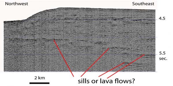
Fig. 7. Screen shot of seismic section off the foot of slope showing possible evidence of sills or lava flows in the sediment section.
The weather station and the radiation flux measurements are running well. Icing on the sun time detector has become less of a problem and power for the fan for the radiation detectors are provided by 12 volts directly from the hovercraft.
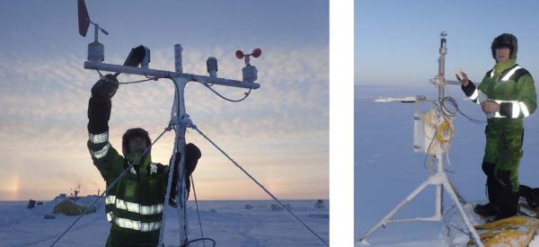
Fig. 8 Attending to the weather station (left) and the instruments for measuring the radiation flux (right). The camp in the background (left).
There has been no sign of animal life in our neighborhood during the week.
Despite the cold, life in the High Arctic is treating us well.
Yngve Kristoffersen & Audun Tholfsen
Daily reports
Monday 09 March.
Position: 86° 05.3' N, 44° 26' W, temperature - 25° C, air pressure 990 hPa, wind 14 knots from the W. Ice drift 0.2 knot to the E. Shooting seismic reflection all day. Checked radiation flux instruments - all sensors Ok even sun time detector. Also weather station OK. Audun determined by GPS true heading of the hovercraft to be 81 degrees. The thin crack near the thermistor string has widened to 20 cm. Put a tarp under the rear end of the hovercraft to seal off air leakage.
Tuesday 10 March.
Position: 85° 59.6' N, 43° 41' W, temperature -21° C, air pressure 997 hPa, wind 14 knots from the NW. Ice drift 0.3 knot towards SE. White-out all day. About 10 cm of snow the last 24 hours. Shooting seismic reflection all day. Checked the radiation flux instruments and sensors were fine.
Wednesday 11 March
Position: 85° 52.2' N, 43° 01' W, temperature - 24° C, air pressure 1006 hPa, wind 16 knot from the NW. Ice drift 0.3 knots towards SE. Shooting seismic reflection all day. Checked radiation flux instruments and weather station - all OK. Moved fuel from storage towards camp by pumping and moving bladders in relay. Cleared snow from the skirt.
Thursday 12 March
Position: 85° 50.3' N, 42° 35' W, temperature - 26° C, air pressure 1008 hPa, wind 12 knots from the NW. Ice drift 0.2 knot to the E. The sky was clear and we saw the sun for the first time this year. The whole disc was a already a couple of degrees above the horizon. Its presence sure makes a difference. Shooting seismic reflection all day. Audun made a ski trip to the nearest bathymetry buoy 1.7 km out for a check on functionality.
Friday 13 March
Position: 85° 48.9' N, 42° 12' W, temperature - 29° C, air pressure 1012 hPa, wind 1 knot from the NW. Ice drift 0.0. Shooting seismic reflection all day. Checked radiation flux instruments and cleaned IR (up) and sun time sensors. More work on moving fuel. The fuel consumption needed to get the data acquisition going is a growing concern.
Saturday 14 March
Position: 85° 48.3' N, 42° 03' W, temperature - 31° C, air pressure 1011 hPa, wind 2 knots from the S. Ice drift 0.1 knot to the SE. Shooting seismic reflection all day. Checked radiation flux instruments and weather station and removed snow and frost. Audun went and brought back bathymetry buoy # 3 for check.The crack near the thermistor string has widened to 3 meter
Sunday 15 March.
Position: 85° 47.4' N, 42° 05' W, temperature - 31° C, air pressure 991 hPa, wind 10 knots from the N. Ice drift 0.1 knot towards S. Shooting seismic reflection all day. White out and blowing snow. The friendly crack about 55 meter from the craft separating the thermistor string from the rest of the camp widened yesterday to 3 meter and has now narrowed to about 2 meter. It runs 8 meter from the thermistor string and 20 meter from the radiation-flux instruments. The first Jet-A1 drum of fuel for 3 stoves lasted for 11 days.