
(20 - 27 April 2015)
Ice drift
The ice camp moved 53 nautical miles (98.5 km) during week 34 (Fig. 1). Steady 20-30 knot winds from the west were generated by a region of low surface air pressure centered at the North Pole up until Wednesday 22 April. Continued westerly winds were subsequently forced by a strong high pressure cell over the Canadian Arctic Islands for the remainder of the week (Fig. 2).
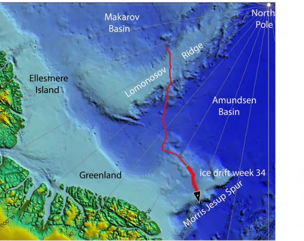
Fig. 1a. The drift of FRAM-2014/15 during week 34, 20 - 27 April 2015 (heavy red line). Thin red line indicates start of 570 km long seismic transect from the Makarov Basin to the Morris Jesup Rise.
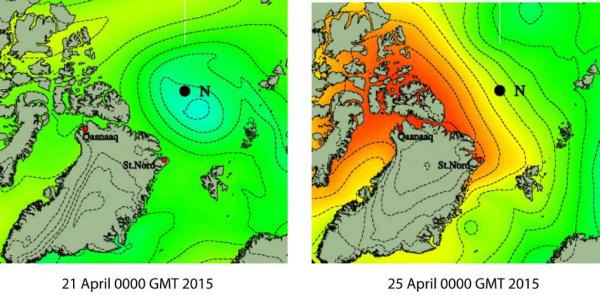
Fig. 2. Main surface air pressure states during week 34 giving steady winds from the west at our location north of Greenland.
Sea ice dynamics
No ice activity has been observed during the week in spite of the high winds.
Camp life
Air temperatures were around -20° C during the first part of the week while under the influence of the low pressure centered at the North Pole. The high surface air pressure over the Canadian Arctic during the rest of the week brought in air about 5 degrees warmer. This was a major change from the cold at the beginning of the month and outdoor work got easier in many ways. Our hydro hole does not freeze up any longer. Low clouds and white-out conditions have persisted throughout the week along with the high winds, but the effect of the sun is getting stronger as soon as it clears a bit.
This week has been busy and scientifically rewarding. Undersea features with major changes in water depth always present new opportunities. We use the camera sled to follow what the bottom looks like and what life forms exists. With the seismic data we image the sub-bottom layering down to at least 1.5 kilometer below the seabed. The video from life at the bottom provides interesting entertainment. In the sequences from the last run, one starfish after another (6) came out of nowhere and went for a certain point on the kevlar line, tried to embrace it and then left. In a previous run a big fish (Lycodes Frigidus?) was trying to bite off the line.
Blowing snow is a consequence of high winds and a matter of constant concern. Snow drifts up to two meter thick, ten meter wide and several tens of meters in length accumulated over weeks have given us problems several times in the past. Now, with the increasing effect of the sun, there is less dry snow to move and drifts are small. We keep a free passage around the skirt of the hovercraft in case the need arises to leave the site on a short notice.
We store our food in aluminum boxes (Zarges) and wooden crates on the ice in the camp area. They are exposed to the sun which is getting higher and is with us day and night. For this reason, we are starting to make a snow and ice shelter for our frozen food.
Science
Underway continuous measurements:
Bathymetry and sub-bottom profiling:
- one autonomous echo sounder buoy reporting to shore via Iridium
- single channel seismic reflection measurements, 98 kilometer
Oceanography:
- one Aanderaa current meter at 800 meter depth.
Atmosphere:
- measurement of incoming and outgoing radiation from the ice surface
- surface infrared skin temperature
- sun time
- Aanderaa weather station
Station work
- 5 short sediment cores, 35-55 cm long, water depths 1160 to 1750 meter
- 5 camera sled deployments, water depths 1080 to 1650 meter.
-
Morris Jesup Spur - more a pile of sediments than a volcanic construction?
The ridge extending north from the north coast of Greenland (Fig. 1) was given the name Morris Jesup Rise by American map makers Bruce Heezen and Marie Tharp in the early 1970's. Their map of the Arctic Ocean appeared in an issue of the National Geographic Magazine and portrayed the bathymetry in terms of the new paradigm of sea floor spreading. The ridge extends from Kap Morris Jesup, the northernmost point on mainland Greenland, named by Robert Peary after his sponsor, a New York banker. The official name is now Morris Jesup Spur approved in April 2003 by the GEBCO Sub-committee on Undersea Feature Names at the International Hydrographic Bureau in Monacco.
To the best of our knowledge, the Morris Jesup Spur has only been crossed by the U.S. ice station ARLIS II in 1965 doing seismic reflection measurements with a sparker source and visited at its northeastern end by Polarstern in 1991. Present bathymetric definition of the feature is mostly in the state of an outline with the exception is the NE-corner visited by swath-mapping icebreaker surveys. The water depths along our track are 100 to over 400 meter different from what can be inferred from the latest version of the bathymetric map. The top of the spur is portrayed on the map as relatively flat, and about 10 km wide. Our present position on the map should be about the middle of the flat area, but depths from the seismic section indicate we are still on the NW-flank (Fig. 3).
Most surprising is the presence of more than 1.5 sec. ( ̴ 1.5m km) of sediments. We have only observed possible knolls of volcanic basement buried by sediments in the far NW. For the rest of the track, basement is not detected and covered by more than 1.5 km of sediments. We do, however expect to see a narrow basement ridge before a precipitous increase in water depth to more than 3.000 meter about 25 kilometer to the east of our present position. The observed sediment thickness has several implications: 1) the amount of volcanic material associated with Morris Jesup Spur may be far less than hitherto considered; 2) where did all the sediments come from and 3) what hydrodynamic conditions induced sediment deposition in the form of a spur. The upper 0.8 sec. of the section appears as a drape, evidence of current controlled deposition is absent and only a few very minor sub-marine channel features can be seen. Vertical stacks of diffractions in a few places suggest the entire sediment section has been cut by relatively recent faults.
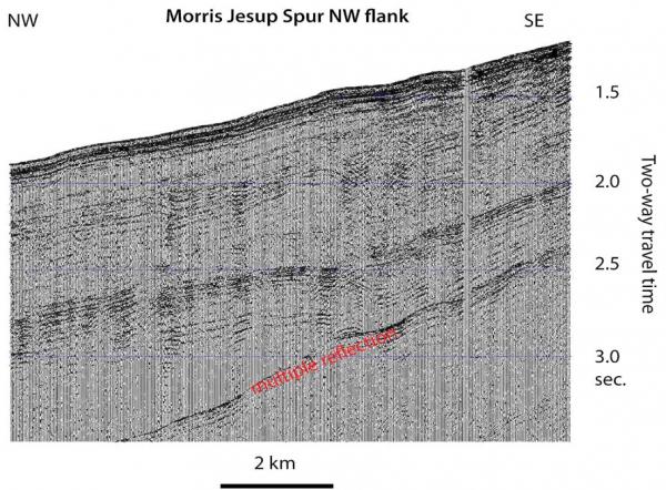
Fig. 3. Screen shot of seismic monitor with data from the northwest flank of the main Morris Jesup Spur showing layered sediments below the seabed down to at least the level of the multiple reflection.
Life on the seabed
We have deployed the camera sled at five locations in water depths from 1080 to 1650 meter. In two of the deployments on the muddy slope, fish comes into the field of view (Fig. 4). In one case, it appears to be a Lycodes frigides species as also encountered at several sites on Lomonosov Ridge. In the other case two fishes swimming together have tentatively been identified as Gaidropsarus argentatus (courtesy of J. Schou Christensen, Univ. of Tromsø). A video clip of the latter is attached to this report.
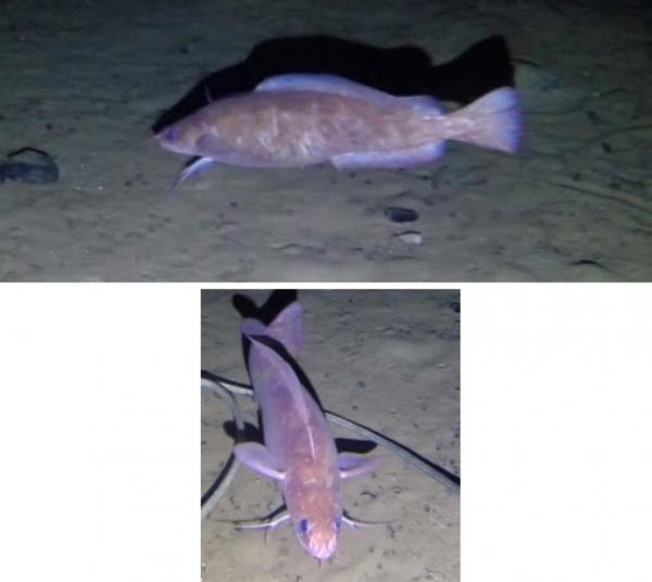
Fig. 4. Fish imaged by the bottom camera sled on Morris Jesup Spur
There has been no sign of animal life in our neighborhood during the week.
The spring is here and life in the High Arctic is treating us well.
Yngve Kristoffersen & Audun Tholfsen
Daily reports
Monday 20 April
Position: 85° 14.5' N, 27° 25' W, temperature - 22° C, 1009 hPa, wind 26 knots from the W. Ice drift 0.4 knot towards E . Shooting seismic reflection all day. Audun changed memory card and battery on the radiation flux instrument. Battery was 12.2 volt, but only data for 21-24 March on the card. The stoves in the cabin went out before noon, and the temperature fell to below +10°. The problem was a valve in the the primer pump. Had to improvise a temporary solution with a 20 liter diesel tank inside.
Tuesday 21 April
Position: 85° 12.5' N, 26° 10' W, temperature - 19° C, 1010 hPa, wind 25-30 knot knots from the SW. Ice drift 0.5 knot towards E. Shooting seismic reflection all day. Recovered one short sediment core in 1.340 meter water depth and made one camera sled deployment in 1.430 meter water depth. Observed two large fishes in the video from the seabed.
Wednesday 22 April
Position: 85° 07.8' N, 24° 22' W, temperature - 22° C, 1016 hPa, wind 18 knots from the W. Ice drift 0.4 knots to the ESE. White-out all day. Shooting seismic reflection measurements. Camera sled at the bottom 1845-2130 hours. Side drag in the kevlar line during the fast drift cause the sled to lift off bottom.
Thursday 23 April
Position: 85° 00.5' N, 23° 32' W, temperature - 20° C, air pressure 1029 hPa, wind 24 knots from the NW. Ice drift 0.4 knot towards the SE. Shooting seismic reflection measurements all day. Recovered two short sediment cores in 1.160 and 1.700 meter water depth, respectively. The camera sled at the bottom 1415- 1700 hours.
Friday 24 April
Position: 84° 52.3' N, 22° 26' W, temperature - 14° C, pressure 1039 hPa, wind 23 knots from the NW. Ice drift 0.4 knot towards ESE. Shooting seismic reflection all day. Recovered on short sediment core from 1.750 m water depth. Moved the radiation flux-instrument mast 20 meter towards the weather station because the large snow drift behind our work space was approaching the site.The weather has improved slightly so Audun removed the outside day tank for heating fuel for inspection. The fuel outlet had ice up. Cleaned the tank and we were back to normal.
Saturday 25 April
Position: 84° 48.8' N, 21° 42' W, temperature - 15° C, air pressure 1040 hPa, wind 28 knots from the W. Ice drift 0.4 knot towards SE. hooting seismic reflection all day. One short sediment core recovered from 1.630 meter water depth. The camera sled at the bottom from 1730 to 2030 hours. Put an eight kilo weight on the Kevlar to weigh it down and prevent the sled to lift off bottom. One bluish fish observed.
Sunday 26 April
Position: 84° 42.7' N, 20° 43' W, , temperature - 13° C, air pressure 1035 hPa, wind 22 knots from the W. White-out all day. Shooting seismic reflection all day. Audun remeasured reference directions. The hovercraft is pointing in the direction of 241°. Azimuth of North-direction for the weather station and the radiation flux instrument is now 013°. The camera sled deployed in 1000 meter water depth. Audun visited bathymetry buoy "1 about 1.7 km out. Only minor evidence of recent ice activity near the site. Airgun was leaking and serviced.