
(27 April - 04 May 2015)
Ice drift
. The ice camp moved 17 nautical miles (32 km) during week 35 (Fig. 1). A large cell of high surface air pressure positioned over North Greenland and the Canadian Arctic Islands dominated until Friday May 1 and winds at our location was 8- 14 knot from the NW. The high pressure later moved into the Beaufort Sea and winds were down to 4-6 knots. The ice drift was 0.1 knot for the most part. We have had a complete cloud cover all week and white-out conditions.
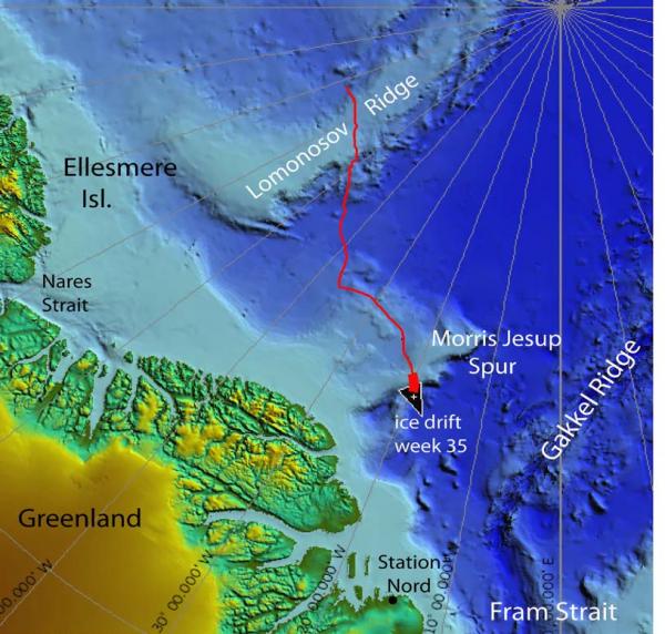
Fig. 1a. The drift of FRAM-2014/15 during week 35, 27 April - 04 May 2015 (heavy red line). Thin red line indicates start of 570 km long seismic transect from the Makarov Basin to the Morris Jesup Rise.
Sea ice dynamics
No ice activity has been observed during the week.
Camp life
Drifting over Morris Jesup Spur during the last two weeks has been a bonanza in terms of science opportunities. With the new generator received by the air drop on April 10th, we were back to normal data acquisition capacity and ready for the task. Our camp life during these weeks has been dictated by what action need to be taken from what we infer from the images emerging from the seismic data acquisition. The reward has been a complete change of our perception of what the spur represents in terms of geology. Rather than being a pile of volcanic rocks related to a "Yermakl hot spot" as usually portrayed in the scientific literature, its upper crust is probably for the most part sediments which may even have a resource potential. The joy of experiencing unexpected scientific surprises of nature is something one must be part of to understand the full depth of.
With the focus on the sea bed, little note has been taken of the fact that white-out conditions have prevailed throughout the whole week. Complete lack of contrast from an all-white surface, made it virtually impossible to walk outside the simplest path without stumbling and falling. We have, however enjoyed warmer air with temperatures in the range -17° C to -9° C. We have also been blessed with weak winds and no blowing snow. Unfortunately, the white-out conditions have prevented us from pursuing search for the last two of the autonomous bathymetry buoys (5).
The target areas of this expedition were the submarine ridges. We have now passed over the last ridge, the Morris Jesup Spur and will for the remainder of the drift move over deep water (> 3000 meter depth) as well as ocean floor considered to be younger than 30 million years. At this time, we have acquired over 1.000 kilometer of single channel seismic data during our drift with the sea ice. Our activities will change constrained by the fact that the length of our remaining Kevlar line is 2.800 meter and we also have to restrict our fuel consumption. This means no more seabed work and no more seismic data acquisition. The focus will be more on the water column. Among other issues to be dealt with are rescue of the second current meter at 800 meter depth where the site has been deformed by a pressure ridge. We also need to have a second look for the acoustic Doppler current meter we lost during the first major camp break-up last year as well as the thermistor string lost a month ago.
Science
Underway continuous measurements:
Bathymetry and sub-bottom profiling:
- one autonomous echo sounder buoy reporting to shore via Iridium
- single channel seismic reflection measurements, 32 kilometer
Oceanography:
- one Aanderaa current meter at 800 meter depth.
Atmosphere:
- measurement of incoming and outgoing radiation from the ice surface
- surface infrared skin temperature
- sun time
- Aanderaa weather station
Station work
- 2 short sediment cores, 35 cm long, water depth 810 meter
- 3 camera sled deployments, water depth 810 meter.
- 2 dredge deployments
At the end of this week, we passed 1.000 km of single channel seismic data acquired during the FRAM-2014/15 ice drift. We also completed the 570 km long profile from the Makarov Basin to the Fram Strait. We have operated successfully under challenging conditions with periods of air temperatures down to - 43° Celsius. Once we got stable heat on the compressor and learned why the air gun sometimes goes into auto-fire, the equipment and procedures have performed really well.
Part II: Morris Jesup Spur - more a pile of sediments than a volcanic construction
1. Observations of the spur architecture
We have crossed the Morris Jesup Spur about 100 kilometer north of the shelf break as portrayed on the latest version of the IBCAO map and about halfway out along the length of the spur (Fig. 1). The spur has a 25 km wide flat top in 810 - 830 meter water depth at the site of our crossing (Figs. 2 and 3). The slope to the northwest is about 7°, but is a precipitous 60° to the southeast (Fig.3).
The seismic data show at least the upper 1 kilometer below the seabed (down to the multiple reflection) to be represented by sediments with a 7° northwest component of dip which appears uniform across the spur (Figs. 2 and 3). The sediment layers are truncated at the top across the spur and covered by a c. 100 meter thick sediment drape (Fig. 2). The thickness of the drape does not appear to change from the northwestern slope to the top of the spur. The entire spur is known to be associated with a strong anomaly of magnetic intensity which has been considered as evidence for the entire spur being a volcanic construction.
2. Observations relevant to the glacial history
The northwest dipping strata that mantle the spur are cut by a razor sharp unconformity across the top of the 25 km wide structure (Fig.2). At the southeastern edge is a 3.5 km wide accumulation which rests on the unconformity, and is overlain by the same drape as the rest of the top of the spur (Fig. 3, lower panel). In other words; the process(es) that formed the unconformity and the accumulation at the margin are of the same age. In cross-section the accumulation looks very similar to an end-moraine of a glacier.
3. Observations from the seabed
The video recordings from travel over the seabed show surprises. At the top of the spur, the seabed in the northwestern part is mud with abundant animal tracks, but littered with rock pebbles. In the central part, patches of gravel are abundant, but also patches of a broken up centimeter thick crust of light colored sediments. Towards the southeast, the bottom is muddy with extensive networks of strings of sediments from burrowing animals. A video clip is attached to this report to provide a
visual impression. There also appear to be areas with an abundance of small holes, some isolated cone-shaped sediment mounds and also small cave-like structures (Figs. 4 and 5). The holes are not associated with any indication of where the excavated mass has been disposed.
Concluding remarks
1. The seismic data acquired during the FRAM-2014/15 ice drift across the central part and by the German icebreaker Polarstern in 1991 over the northeastern tip of the Morris Jesup Spur suggest that the structure may consist of two parts; a volcanic northernmost part and a continental southern part (Fig. 1). This also presents an analogy to the structure of the Yermak Plateau north of Svalbard which was juxtaposed to the spur before about 36 million years ago. The strong anomaly in magnetic intensity also associated with the southern part of the Morris Jesup Spur may be due to deep seated intrusions rather than extrusive magmatism. The dip of the sediments at the location of the trajectory of the ice drift station (Figs 1-3) may either be due to uplift in the southeast or be mostly the original dip of continental margin sequences.
2. We interpret the accumulation on top of the regional unconformity at the southeastern rim of the spur as an end-moraine deposited by a grounded glacier (Fig. 3, lower panel). This accumulation suggests the unconformity was generated by a grounded ice shelf, rather than the spur being eroded at or near sea level in the past. The grounded ice shelf would probably have been continuous with mainland Greenland since the bathymetry north of the shelf edge shows no known deep incisions. We submit that the case presented here has the potential of being the best documentation of thick glacial ice extending north of the main Greenland ice sheet. The nearly one hundred meter thick drape deposited since the event indicates an age of several million years.
The idea of thick ice shelves extending into the deep Arctic Ocean is a matter of debate. Bottom features on the main ridges and plateaus are due to the activity of deep draft ice bergs and any continuation with a source in the form of a major glacial ice sheet is unclear.
3. We have benefitted from discussions with Martin Hovland (retired, Statoil) on the observations of small scale features on the seabed. Hovland is the author of numerous publications and several books on aspects of seabed micro-morphology and associated life forms. The small sand volcanos are likely to be formed by fluids transporting sand sized material to the surface (Fig.5. lower panel). The small holes and caves are also formed by escaping fluids where the material is brought into suspension and transported away by the bottom currents. The nature of the fluids may be pore water or gas. However, given the limits of the quality of our seismic data, we observe no apparent amplitude anomalies in the seismic signal which could indicate the presence of fluids or gas.
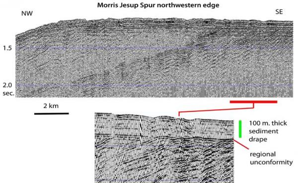
Fig., 2 Upper panel: Screen shot of the seismic monitor of data acquired over the northwestern edge of the Morris Jesup Spur.
Lower panel: Screen shot of the multiple reflection showing the detail of the unconformity and the overlying sediment drape.
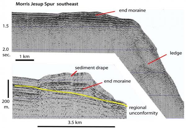
Fig. 3. Upper panel: Screen shot of the seismic monitor showing data over the southeastern edge of Morris Jesup Spur Lower panel: Screen shot of multiple reflection showing detail of the sediment accumulation above the unconformity at the southeastern edge of the spur.
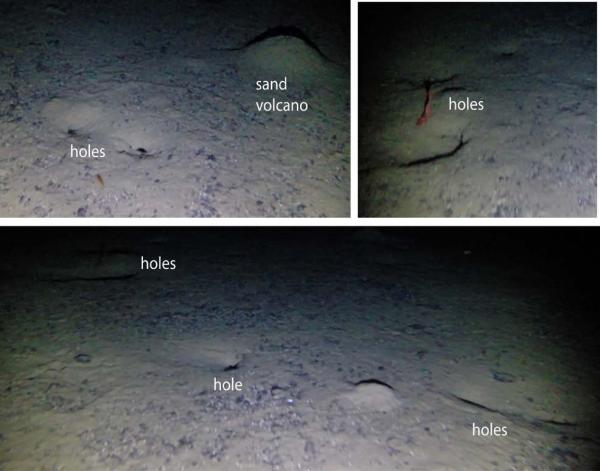
Fig. 4. Bottom photos showing examples of holes in the seabed. Note the lack of expression of where the removed sediments have been deposited.
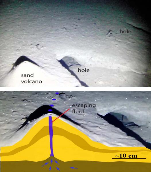
Fig. 5. Upper panel: Bottom photo showing a sand volcano and adjacent caves in the seabed sediments. Lower panel: Conceptual view of the process forming a sand volcano. Illustration courtesy of Martin Hovland.
Still no sign of animal life in our neighborhood so far this spring.
Life in the High Arctic is treating us well.
Yngve Kristoffersen & Audun Tholfsen
Daily reports
Monday 27 April
Position: 84° 39.1' N, 20° 30' W, temperature - 11° C, 1039 hPa, wind 12 knots from the N. White- out. Ice drift 0.0 . Shooting seismic reflection all day. Audun built anenclosure of ice blocks to protect the frozen food from the sun. Moved in most of the frozen stuff. Checked the radiation flux instrument - everything OK.
Tuesday 28 April
Position: 84° 38.5' N, 20° 27' W, temperature - 14° C, 1035 hPa, wind 8 knot knots from the NNW. White-out. Ice drift 0.0 knots. Shooting seismic reflection all day. Had the generator running all day to get hot water for a shower and washing clothes. Put down the 50 kHz and 200 kHz transducer to look for scattering layers in the upper 2-300 meters of the water column. Saw a pronounced layer at about 50 meter depth.
Wednesday 29 April
Position: 84° 36.7' N, 20° 14' W, temperature - 14° C, 1030 hPa, wind 13 knots from the NW. Ice drift 0.1 knots to the SE. White-out all day. Shooting seismic reflection measurements all day. Recovered a short sediment core. Camera sled at the bottom 1230-1530 hours. Observed six fishes and small holes which may have been formed by venting of fluids. Also in places broken pieces of crust of light colored sediment. Deployed the dredge for two hours, but returned empty. Made screen shot of 50/200 kHz echo sounder every six hours.
Thursday 30 April
Position: 84° 32.2' N, 19° 54' W, temperature - 217° C, air pressure 1030 hPa, wind 14 knots from the NW. White-out all day. Ice drift 0.2 knot towards the SE. Shooting seismic reflection measurements all day. Dredge on the bottom 0340-1300 hours - returned only small angular fragment of lightly metamorphosed shist. Camera sled on the bottom from 1400 to 1840 hours. Saw small sand volcano adjacent to opening of two orifices in the bottom. Pumped fuel from the only bladder in camp to the rear tank which became 3/4 full.
Friday 01 May
Position: 84° 30.3' N, 19° 53' W, temperature - 11° C, pressure 1027 hPa, wind 4 knots from the NE. White-out all day. Ice drift 0.0 knot. Continue shooting seismic reflection. Recovered a short sediment core from 820 meter depth at the EE edge of the top of the spur. Reorganized our stock of eggs. Those that were closest to the outer wall in the flotation tank had been frozen and were cracked and had to be disposed of. About 120 out of 400 eggs left.
Saturday 02 May
Position: 84° 29.0' N, 19° 46' W, temperature - 9° C, air pressure 1026 hPa, wind 6 knots from the NE. White-out all day. Ice drift 0.1 knot towards SE. Continue shooting seismic reflection.
Sunday 03 May
Position: 84° 42.7' N, 20° 43' W, , temperature - 13° C, air pressure 1035 hPa, wind 22 knots from the W. White-out all day, but the sun became visible at 1700 hours. Shooting seismic reflection all day. Deployed the dredge in 1400 meter water depth over the southeastern edge of the spur. When recovered six hours later, the first few hundred meters of Kevlar line near the dredge was a mess and the dredge was empty. With this our geological sampling program on FRAM- 2014/15 came to an end. Audun visited bathymetry buoy #1 about 1.7 km out. Only minor evidence of recent ice activity near the site. The airgun was leaking. It was recovered and serviced.