
(04 - 11 May 2015)
- a snow bunting passed through camp 10 May -
Ice drift
The ice camp moved 15 nautical miles (28 km) during week 36 (Fig. 1). Gradients in surface air pressure have been weak throughout the week over large parts of the Arctic Ocean. The higher pressure has been over North Greenland and the Canadian Arctic islands. Winds have been out of the west at our location with 14-17 knot on Monday and Tuesday and less than 8 knot the rest of the week. We have had sun from a clear or partly cloudy sky all week except Friday and Sunday.
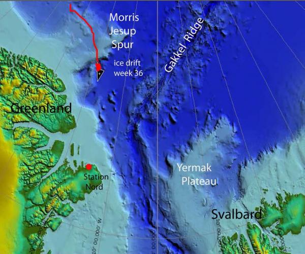
Fig. 1a. The drift of FRAM-2014/15 during week 36, 04 - 11 May 2015 (heavy red line).
Sea ice dynamics
No ice activity has been observed in our neighborhood during the week. However, weak, but persistent westerly winds over the past two weeks have created a large scale fracture pattern north of Greenland upstream of the main outflow of ice from the Arctic Ocean (Fig. 2). A major shear zone is formed at the boundary between the moving sea ice and the land fast ice along the coast of Northeast Greenland. The continued drift of the FRAM-2014/15 ice camp will be largely parallel to this shear zone. At the latitude (81° 30' N) of Station Nord (Fig. 2), the outflow of ice accelerates, the sea ice cover get fragmented and large leads open up between floes.
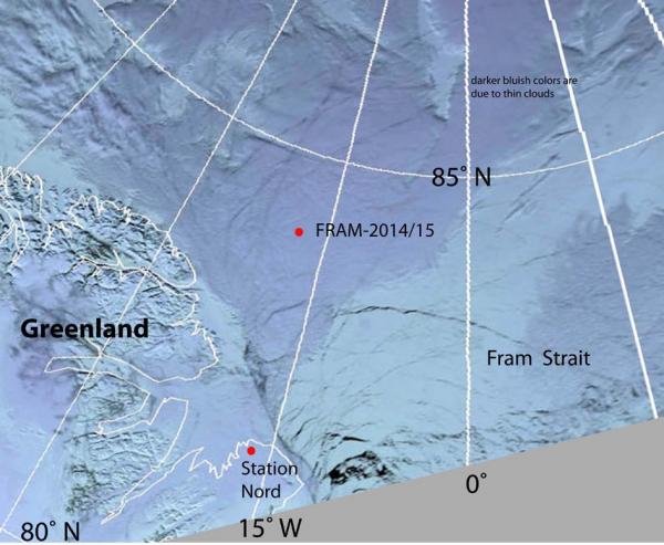
Fig. 2 Satellite image of the ice situation and fracture patterns off northeast of Greenland. Image courtesy of www.woksat.info
Camp life
In our minds, we are on the home stretch, having passed Morris Jesup Spur and all our target areas. We feel the pressure is off in the sense that our days are no longer a chase run by the science opportunities you could read from the seabed at the same time as seismic data acquisition was kept up. To keep the air gun going, required attention which did not allow you to sleep more than 1.5 hours at a time for periods over a month. It took some resolve to keep it up at temperatures down to -40 °C during the dark season. But the data is now stored on the computer disk and the pressure is off.
The air temperatures during the week have varied very little (-14 °C to -18 °C) and the sun has been shining all day except for white-out conditions on Friday and Sunday. The sea ice in the area is approaching the entrance to the Fram Strait (Fig. 2) and ice activity will increase down-stream. So far winds have been weak and the ice drift slow during the past two weeks. To, prepare for a new reality, we have removed the connection between the hovercraft and the work space and closed the opening. The work space over the hydro hole is now a stand-alone building. Next on the logistics agenda is to move equipment and fuel still remaining near the old camp site over to where we are now. Otherwise, possible development of new intervening leads and shear zones may easily displace the cargo many hundreds of meters and ice rubble make it nearly inaccessible. For now, we have to clear a saddle point in a pressure ridge for the hovercraft to pass and get to the old site.
We have used the good weather to search for the two remaining bathymetry buoys (#4 and #5) not yet accounted for (Fig. 3). On Saturday, Audun made a ski trip out to 5 km away from the camp, but could not locate any of them. Earlier in the week, new batteries were connected to buoy # 1, also 4.7 km out from camp.
The air drop by the 333 Squadron was essential to get us back to being useful. With the new generator (number five on this expedition), end of seismic data acquisition, and the warmer weather, we feel we have regained control over our fuel situation. Our revised consumption should bring us safely through wherever the drift ends.
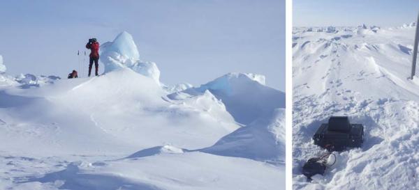
Fig. 3 Left: Audun searching with binoculars for the bathymetry buoys. Right: Each buoy site is marked by a 3 m long plastic pipe, but the buoy itself has a very low profile
Science
Underway continuous measurements:
Bathymetry and sub-bottom profiling:
- one autonomous echo sounder buoy reporting to shore via Iridium
Oceanography:
- one Aanderaa current meter at 800 meter depth
- 50 kHz and 200 kHz echo sounders to look for scattering layers in the upper 200 meter.
Atmosphere:
- measurement of incoming and outgoing radiation from the ice surface
- surface infrared skin temperature
- sun time
- Aanderaa weather station
Station work
- one camera deployment down to 30 meter depth
An essential part of doing science is curiosity. Imaging the seabed and the sub-bottom layers using an acoustic sound source (8 - 120 Hz) have been a major task during the past eight months. When this ended, we turn our attention to acoustic images of the water column out of shear curiosity using the following tools:
i) a sparker source to image acoustic impedance contrasts mainly caused by water temperature differences, and
ii) high frequency echo sounders (50 and 200 kHz) to map scattering layer in the upper few hundred meters. The scattering layer is due to biological activity.
An autonomous seismic buoy using a sparker source was developed as part of an IPY-project and has been used in test runs on Yermak Plateau with good results. When mobilized here, we encounter a short circuit in the sparker energy source and have not been able to resolve it by now, but continue to pursue the issue.
Echo sounders use high frequencies which gives high vertical resolution.The energy transmitted by an echo sounder will be reflected from any obstacle in the water column before it hits the seabed where it is reflected back as a strong return and tells us what the water depth is. The energy reflected back from any target in the water column is dependent on size and acoustic impedance (velocity times density) contrast. At 200 kHz , the wave length is 7.5 millimeter and a tiny bit of energy will be reflected back from life forms down to a few millimeter in size. If there are many small individuals pr. unit volume, we may detect the reflected or back scattered energy as a tiny spot on the screen. If there are clouds or patches occurring, we see many spots over a depth interval that form a layer of some thickness - hence the name "scattering layer". In the open ocean, the scattering layer is found at depths between 200 and 600 meter depth during the day. At night it rises to near the surface and diffuses. The scattering layer is attributed to zoo-plankton which descend to depths during the morning to escape their predators during the day. At night the plankton rises to the surface to feed in the nutrient rich water. In the central Arctic Ocean, the scattering layer was probably first detected from ice station T-3 in the summer of 1963 using a 12 kHz echo sounder. It was found to occur between 50 and 200 meter depth. It showed no diurnal depth variation, but rather an annual variation and was only present during the summer months and early fall, June through October.
Research in the marginal ice zone north of Svalbard has documented that the scattering layer as detected by the 200 kHz echo sounder is mainly due to abundance of species of the copepod Calanus - a zoo-plankton of size up to five millimeter. The signal from the 50 kHz responds to larger targets such as Arctic cod.
We use a Furuno FCV-620 dual frequency (50 and 200 kHz) echo sounder. Our logging system is for the detected bottom echo only and not for the entire data trace from the water column. To record the echoes in the water column, we photograph the echo sounder screen at 6 hours interval. In Fig. 4 and Fig. 5 are shown some sample records. At 200 kHz, the concentration of scatterers vary little around 50 meter depth. The 50 kHz signal on the other hand, show large irregular variations both during the day and at night time. Particularly large co-occurring concentrations were observed in the evening of May 8th (Fig. 6).
Our only means of in situ documentation is to attempt video recording at the depth of maximum concentration. We deployed the GoPro camera and a light source down to 30 meter depth. Individual plankton can be seen passing in and out of the field of view, but insufficiently resolved. This video approach may only be useful for the larger targets detected by the 50 kHz signal.
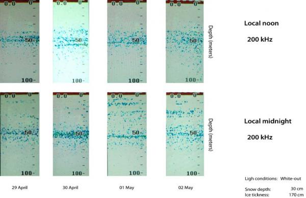
Fig. 4 Records of the scattering layer as detected by the 200 kHz echo sounder
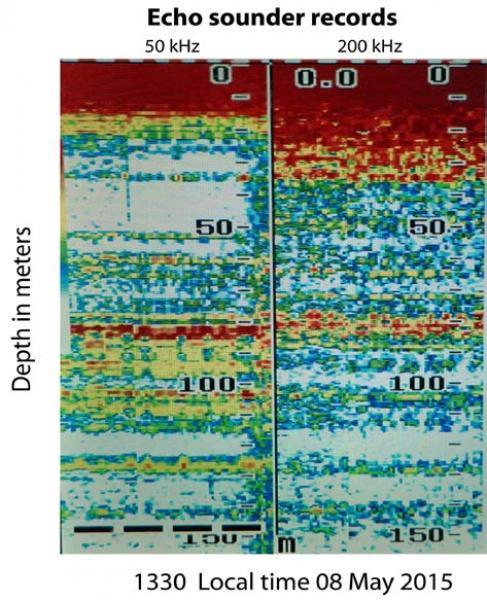
Fig. 5. Records of the scattering layer detected by the 50 kHz echo sounder
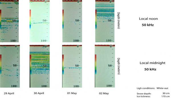
Fig. 6 Echo sounder record from an event of extremely strong returns from the upper 150 meter of the water column.
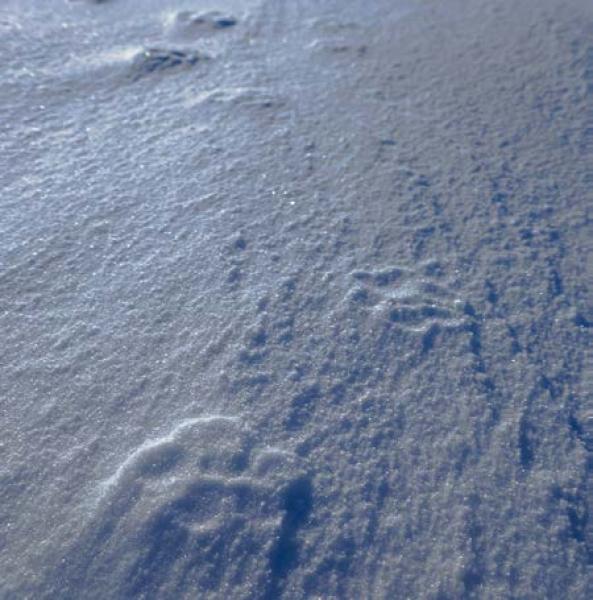
Fig. 7 Foot prints of the polar fox which passed by our camp
Audun spotted tracks of a polar fox which had inspected our camp from the nearest pressure ridge. The fox used the occasion to leave droppings which have been collected and will be turned over to relevant experts who can read the information.
On Sunday May 10th, we welcomed a snow bunting which touched down at 1532 hours on the hovercraft and later left for an unknown destination.
Life in the High Arctic is treating us well.
Yngve Kristoffersen & Audun Tholfsen
Daily reports
Monday 04 May
Position: 84° 23.3' N, 19° 15' W, temperature - 18° C, 1025 hPa, wind 17 knots from the NW. Ice drift 0.2 towards SE. At 1600 hours, our seismic program had come to the end. Stopped data acquisition and pulled the air gun out of the water - last field file is # 40370. Take screen shot of the 50/200 kHz echosounder at least at local noon and local midnight.
Tuesday 05 May
Position: 84° 18.3' N, 18° 42' W, temperature - 17° C, 1021 hPa, wind 14 knot knots from the NW. A clear day. Ice drift 0.2 knot towards SE. Audun restarted data logger on radiation flux instrument. He also made a ski trip with batteries to bathymetry buoy # 1 at 4.7 km out from our camp, but was missing a tool to complete the job.
Wednesday 06 May
Position: 84° 13.2' N, 18° 09' W, temperature - 15° C, 1024 hPa, wind 6 knots from the NW. Ice drift 0.2 knots to the SE. Sunshine from a clear sky all day. Audun went back to the site of buoy #1 and connected up the batteries. The old ones measured 5.5 V and 7.2 V, respectively. Removed the heat enclosure from the compressor and tidied up. Moved the sparker buoy into the work tent. Audun rechecked the radiation flux data logger and rebooted the program. Making pictures of the scattering layer.
Thursday 07 May
Position: 84° 11.8' N, 17° 59' W, temperature - 16° C, air pressure 1029 hPa, wind 2 knots from the W. White-out from 0900 hours. Ice drift 0.1 knot towards the SE. Cleared the workspace from its connection to the hovercraft - only generator power line attached. Connected up the sparker buoy.
Friday 08 May
Position: 84° 11.3' N, 17° 59' W, temperature - 14° C, pressure 1032 hPa, wind 6 knots from the SSE. Sun from a clear sky all day. Ice drift 0.0 knot. Deployed the hydrophone for the sparker buoy. Got the control electronics checked out OK, but the sparker energy source kept blowing a fuse and the problem was not found. A more permanent location inside the work space was made for the generator.
Saturday 09 May
Position: 84° 10.9' N, 18° 00' W, temperature - 14° C, air pressure 1030 hPa, wind 5 knots from the S. Sunshine from a clear sky all day. Ice drift 0.1 knot towards ESE. Audun went on skies to search for bathymetry buoy # 4 and # 5, but did not find any. Worked on the sparker buoy to look for shorted connections. Made a frame for mounting the camera and underwater light source in an effort to see of we may be able to get video of the life forms that make up the scattering layer in the upper 150 meter below the ice. Made a camera deployment to a weak consentration of scatterers at 30 meter depth. A few individuals can be seen passing through the field of view, but the resolution is insufficient. We
have to go for the bigger targets sometimes displayed in the results from the 50 kHz echogram.
Sunday 10 May
Position: 84° 10.3' N, 18° 01' W, , temperature - 15° C, air pressure 1027 hPa, wind 8 knots from the NW. White-out all day. Ice drift 0.0 knot. Audun moved a Jet A-1 drum to camp to be used for heating. An ice house for storage of food was expanded. A snow bunting suddenly touched down on the roof of the hovercraft at 1532 hours. Rather than restitute and stock up on food in our camp, the bird left after just a few minutes.
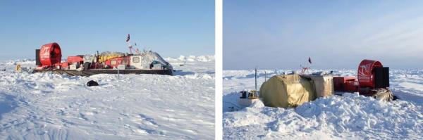
The FRAM-2014/15 camp as of May 10 2015.