(11 - 18 May 2015)
Ice drift
The ice camp moved 8 nautical miles (15 km) during week 37 (Fig. 1). Early in the week, the general state of high air pressure over the Arctic Ocean was intruded by a low pressure moving north from the East Siberian Sea (160° E). Winds in our area were weak (3-7 knot) and from the east and southeast. The ice drift was slow and to the northeast - we moved back to where we came from. By mid-week, we came under the influence of a low pressure moving north from the Laptev Sea and became stationary in the North Pole area. Winds were now from the north at speeds of 13-16 knot which changed the ice drift to the southeast and increased the drift speed to 0.3 knot. We have most of the time had a full cloud cover and poor visibility with brief intervals of the sun breaking through.
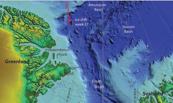
Fig. 1. The drift of FRAM-2014/15 during week 37, 11 - 18 May 2015 (heavy red line).
Sea ice dynamics
No ice activity has been observed in our neighborhood during the week. A thick cloud cover has prevailed throughout the week and features of the regional ice surface are obscured in satellite images.
Camp life
This week has been devoted to various logistic chores and observations of the scattering layer. Although the air temperatures have been pleasant ( -12 °C to -16 °C), the persistent weather conditions characterized by low clouds with near white-out conditions, is not particularly inspiring. The diffuse light gives low terrain contrast which makes it impossible to drive the hovercraft safely. Moving the remaining equipment and fuel over from the old camp has been postponed. We also want to transfer the remaining diesel fuel from the bladder to empty Jet A-1 drums in order to make all our fuel polar bear safe. We are likely to get visits by polar bears in the near future.
Our drift at the moment is about 66 nautical miles off the coast of Northeast-Greenland and we are not likely to get any closer to shore downstream through the Fram Strait
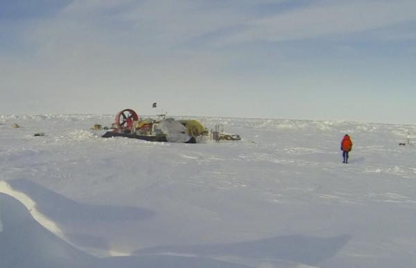
The FRAM-2014/15 camp on 17 May 20115.
Science
Underway continuous measurements:
Bathymetry and sub-bottom profiling:
- one autonomous echo sounder buoy reporting to shore via Iridium
Oceanography:
- one Aanderaa current meter at 800 meter depth
- 50 kHz and 200 kHz echo sounders to look for scattering layers in the upper 200 meter.
Atmosphere:
- measurement of incoming and outgoing radiation from the ice surface
- surface infrared skin temperature
- sun time
- Aanderaa weather station
Station work
- 3 camera deployments to 36, 55 and 36 meter depth, respectively
- One 12 hour time-lapse of 50 kHz and 200 kHz echo sounder display
We have experimented a bit with how to get information of the scattering layer with what we have. Our challenge is the underwater light sources which are insufficient and often fail. The scattering layer seen on the 200 kHz echogram is present all the time. These echoes are probably caused by the abundance of zoo-plankton. The larger life forms however, as detected by the 50 kHz signals, is more sporadic. We may be able to capture the larger objects in underwater images.
We have made a 12 hour time-lapse of the scattering layer as displayed on the screen of the echo sounder. The time-lapse runs from 2100 hours to 0900 hours local time (sun time). The file was planned to be attached to this report, but we are unfortunately unable to reduce the file (30 Mb) to a size useful for transmission via Iridium.
To image the life forms in the scattering layer, we lowered the underwater camera down to the level of maximum echo returns and left it for up to 3 hours. The marine life appeared in no way to be attracted by the underwater lights. What was caught in the field of view appeared to be more or less by accident. This is very different from our camera runs on the seabed in the deep ocean where the lights attracted numerous individuals soon after arrival. Some results from the lowering to 55 meter depth are shown in Figs. 2 and 3. The relatively poor definition in these images are related to their origin as a video recording and also to the fixed focus of the GoPro camera. The quality can be partly improved by a time-lapse approach. Our scientific background in marine biology is completely missing and we kindly encourage interested individuals to help identify the species in the figures to the extent the photo quality allows.
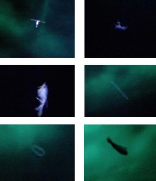
Fig. 2. Single pictures from the video showing different life forms at 55 meter depth within the scattering layer at local noon 15 May.
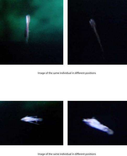
Fig. 3. Single pictures from the video showing different life forms at 55 meter depth within the scattering layer at local noon 15 May.
We cut the CTD program over the deep water transect after Lomonosov Ridge due to fuel considerations. The new generator brought relief and the lowered general consumption give reasons to reconsider. To define research objectives, we have benefitted from discussions with S. Rysgaard, Univ. of Aarhus, B. Rudels, Finnish Inst. of Marine Research, and P. Haugan, Univ. of Bergen. A transect off Northeast -Greenland with temperature and conductivity (salinity) measurements would:
i) augment ongoing oceanographic research in the Independence Fjord area by the group from Aarhus University at the new Villum Research Station, and
ii) contribute to the data base for determining where and how much of Atlantic Water from the Amundsen and Nansen basins joins the flow of water which has made the complete polar basin loop.
We will start making CTD casts down to 1000 meter depth at least every 10 nautical mile.
The return from the ice
We have learned that it will not be possible to obtain support from the Norwegian Coast Guard vessel Svalbard for recovery of FRAM-2014/15 at the end of the drift in the Fram Strait. The reason given is time spent in support of other government institutions.
We actively search for other opportunities to recover all equipment and ensure a safe return to shore.
Wild life
We have not made any observations of animal or bird life on the ice during the week.
Life in the High Arctic is treating us well.
Yngve Kristoffersen & Audun Tholfsen
Daily reports
Monday 11 May
Position: 84° 10.1' N, 18° 00' W, temperature - 12° C, 1024 hPa, wind 3 knots from the SE. Ice drift 0.0. Cleared a passage through a pressure ridge for driving to the old camp. Audun revisited the 2014 camp for photo documentation of changes.
Tuesday 12 May
Position: 84° 10.5' N, 18° 02' W, temperature - 16° C, 1016 hPa, wind 4 knot knots from the SE. A clear day before lunch, white-out afterwards. Ice drift 0.1 knot towards NE. New attempt to figure out the problem with the sparker energy source, no success. Lowered the camera to 36 meter depth in the scattering layers. No good close-up images of zoo-plankon. Taking pictures of the echo sounder screen every 6 hours to capture the activity in the scattering layer.
Wednesday 13 May
Position: 84° 10.8' N, 18° 07.4' W, temperature - 16° C, 1017 hPa, wind 6 knots from the E. Ice drift 0.1 knots to the NE. Poor visibility all day, but not full white-out conditions. Prepared the hovercraft for a drive by i) clearing snow and ice accumulated between the inner and outer skirt, ii) clearing the decks and iii) remove the snow from behind to form a passage for re-entering our present parking position. Checked the radiation flux instruments and data logger. Received an e-mail from the Danish group operating the new Villum Research Station at St. Nord proposing up-stream CTD casts to supplement their oceanographic work in Independence Fjord.
Thursday 14 May
Position: 84° 11.2' N, 18° 13.5' W, temperature - 15° C, air pressure 1018 hPa, wind 7 knots from the NE. White-out. Ice drift 0.1 knot towards the NE. Checked the radiation flux instrument. Continued transferred of the sesmic log to an Exel-sheet.
Friday 15 May
Position: 84° 11.3' N, 18° 15' W, temperature - 15° C, pressure 1014 hPa, wind 11 knots from the N. Poor visibility, but not quite white-out. Ice drift 0.0 knot. Camera down for 2.5 hours at 55 meter depth. A number of useful passages of copepods, polar cod and others. Audun attempted a ski trip to look for the missing bathymetry buoys, but aborted due to poor visibility. Continued transferred of the sesmic log to an Exel-sheet.
Saturday 16 May
Position: 84° 08.8' N, 18° 07' W, temperature - 14° C, air pressure 1015 hPa, wind 17 knots from the N. Poor visibility all day. Ice drift 0.3 knot towards SE. Mounted new lights on the camera rig. Made tests of time-lapse photography of the echo sounder screen. Continued transferred of the sesmic log to an Exel-sheet.
Sunday 17 May
Position: 84° 04.1' N, 17° 20' W, , temperature - 12° C, air pressure 1016 hPa, wind 16 knots from the WSW. Ice drift 0.3 knot to the SE. Poor visibility before lunch, improved later. Deployed the camera at 36 meter depth for 2.5 hours, but no good images obtained. Completed transfer of the seismic log to an Exel sheet.
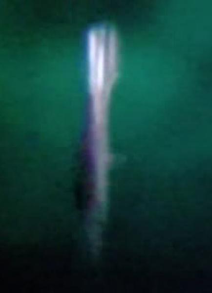
A squid?