
Brief summary of our knowledge of the origin of Lomonosov Ridge
The ship FRAM drifted over the Eurasia Basin between 1893 and 1896 and measured water depths to be over 3.000 everywhere. From that Nansen proposed that the entire Arctic Ocean was a deep basin. Doubts were raised already in 1904 by R. Harris of the U.S. Coast and Geodetic Survey. He studied the tidal wave which came from the Atlantic Ocean through the Fram Strait and crossed the Arctic Ocean. The tide hit the north coast of Alaska several hours too late. There had to be obstructions along its path. The Norwegian oceanographer J. Fjeldstad who analyzed the records of ocean tides obtained during the MAUD- expedition also concluded that there had to be a barrier across the Arctic Ocean. In 1953, the American oceanographer Wortingthon landed with a light Cessna airplane on sea ice north of Alaska and discovered that the deep water on the Alaska side was 0.5° C warmer compared to Nansen's measurements on the European side of the Arctic Ocean; were there two separate deep basins? The unknown divide was Lomonosov Ridge discovered in 1948 from depth soundings made by Soviet scientists and later outlined by measurements made by Soviet aircraft landings and ice drift stations North Pole-3 and -4.
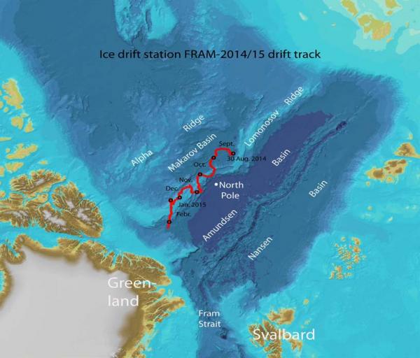
Fig 2. Drift track of ice station FRAM-2014/15 over Lomonosov Ridge
The 1750 km long Lomonosov Ridge is a submarine mountain chain of dimensions that surpasses the Alps of Central Europe. It is flat-topped and raises more than 3 km above the abyssal plains on either side. Its width as defined by the 2000 m isobath range from 40-70 km in the central area near the North Pole to 150-200 km at both ends (Fig. 1).
Three scientific contributions in the 1960-ties stand out as conceptual break-throughs;
i) documentation of earthquake activity in the Eurasia Basin and the proposed extension of the volcanic mid-ocean ridge system into the Arctic Ocean by the American scientists B. Heezen and M. Ewing in 1961;
ii) The Canadian geologist J. Tuzo Wilson’s (1963) suggestion of the origin of Lomonosov Ridge as a continental sliver rifted off the Barents-Kara sea margin, and
iii) the significance of magnetic lineations in the Eurasia Basin emphasized by the Soviet scientist A. Karasik in 1968.
The impact of these ideas was that:
1) the presence of earthquakes tells us that the Eurasia Basin of the Arctic Ocean has an active mid-ocean ridge and is widening along with the rest of the Atlantic Ocean but at a slower rate;
2) the lineations in magnetic field intensities tells us that this process has been going on for about 56 million years. The "young" part of the Arctic Ocean between Svalbard and the Lomonosov Ridge evolved simultaneously with Norway moving away from Greenland and the Norwegian-Greenland Sea was formed.
3) when you go back in time, the original position of Lomonosov Ridge was the outer part of the continental margin north of Svalbard and Severnaya Zemlya.
The sediments on top of the ridge can document the history of vertical movements of the ridge (Fig. 2). Russian seismic reflection and refraction work by Demenitskaya and Kiselev began in 1961 on top of the central part of Lomonosov Ridge and outlined the basic sedimentary units. Thirty years later, the first multi-channel seismic reflection profile obtained by Polarstern across the ridge in 1991, enabled the German scientist W. Jokat and coworkers to display the geometrical relationship between the depositional units reported by the Russian investigators; a progading wedge, cut by an erosional unconformity and capped by a 400 m thick hemi-pelagic drape (Fig. 2). The outbuilding or progradation was towards Makarov Basin as would be expected if the ridge once represented the former continental margin of polar Europe suggested by Wilson in 1963 (Fig. 1). The unconformity suggested that the top of the ridge had been subjected to erosion above or at sea level for some time during the rift process. The ridge later subsided and the c. 400 m thick sediment drape was deposited. The first scientific drilling expedition of the Integrated Ocean Drilling Program to the central Arctic Ocean near the North Pole in 2004 included two icebreakers and an ice-going supply vessel as drill ship. They drilled through the 420 meter thick sediment drape on top of the ridge and sampled rocks above and below the erosional unconformity. Sediments below the unconformity represented a Late Cretaceous (84 mill.years ago) shallow water environment. Deposition started as the ridge subsided below sea level at about 56 Ma following its separation from the Barents-Kara sea margin. It since received a sediment drape containing a rich repository of proxies for the paleoenvironment during the last 56 million years, one being the first appearance of sand-sized grains interpreted as sediment transported by the first sea ice which appeared at about 44 million years ago. Then there is a 28 million year time gap which we at this point have no convincing explanation for. When sediment deposition resumed at 18 million years ago, there is a major palaeo-oceanographic event related to the oceanographic effect of the opening of the Fram Strait for significant water mass exchange at about 17 million years ago.

Fig.2 Cross section of Lomonosov Ridge near the North Pole. Portion of seismic section near the edge at the top of the ridge (upper panel) to demonstrate the key geometrical relationship that helps us interpret the geological history of the ridge. The seismic line was collected by the German icebreaker Polarstern in 1991.
How can FRAM-2014/15 contribute?
The drift of ice station FRAM-2014/15 has covered about one quarter of the length of the Lomonosov Ridge and includes five crossings and 1.050 km of track within the confines of its foot of slope (Fig. 1). A major portion of the coverage relates to areas of the ridge not hitherto accessed by icebreaker surveys. Data have been obtained to provide new knowledge in the following fields of science:
Geology: c. 800 km of single channel seismic reflection data One? sediment core containing old sediments? 3 short sediment cores for the Ice2Ice climate project 2820 depth soundings by autonomous buoys 7 deployments of a towed camera sled
Some issues: i) did the "old" Arctic Ocean open along a sheared margin at the foot of slope in the Makarov Basin?
ii) how much of the ridge was above sea level at 56 Ma.?
iii) the extent of sea ice in the Arctic Ocean during warm climate periods.
iv) new depth soundings to improve the definition of ridge morphology
v) video images of life on the bottom document the fish species present
Oceanography:
Current measurements at 2000 and 800 meter depth in the basin and at 1.050 and 800 meter depth over the ridge.
Measurements of microstructure in the sea water temperature field down to 300 meter depth below the ice during four crossings of the ridge.
Some issues: i) first direct long term direct measurement of the general velocity field of the contour-following currents along the slopes of Lomonosov Ridge on both sides. ii) variations of the microstructure in the temperature field and thereby upper ocean vertical heat transport over the annual cycle
Atmosphere: Measurements over the annual cycle of incoming radiation from space and the atmosphere hitting the sea ice surface as well as outgoing radiation emitted from the ice supplemented by data of the local weather
Some issues: Obtain ground truth documentation of the surface heat budget through the full annual cycle in the central Arctic Ocean.
25 March 2015 at 85° 25' N, 37° 26' W
Yngve Kristoffersen & Audun Tholfsen