Exploring the Arctic Ocean environment - the Arctic ice drift station FRAM-2014/15
by Yngve Kristoffersen and Audun Tholfsen
An ice drift station is a logistic alternative to explore areas of the Arctic Ocean not accessible to icebreakers, and to carry out scientific field experiments, which require physical presence and cover the full annual cycle. The Nansen Center (NERSC) has in co-operation with A. Wegener Institute for Polar and Marine Research (AWI) in Germany, explored the advantages of a joint operation between an icebreaker and a hovercraft to implement a cost effective scientific and logistic ice drift station. One hundred and eighteen years after Nansen's drift with FRAM, the next Norwegian ice drift station FRAM-2014/15 was deployed near the North Pole in August 2014 using a medium-sized hovercraft as logistic and scientific platform. The hovercraft operated by a crew of two persons, is equipped as a scaled-down modern research vessel. By end of March 2015, FRAM-2014/15 has drifted 1.450 km and made five crossings over about one quarter of the length of the Lomonosov Ridge. The ridge is a 3 km high submarine mountain chain, which divides the polar ocean into two deep basins. A major portion of the coverage relates to areas of the ridge not hitherto accessed by icebreaker surveys. The Norwegian and Danish air forces have supplied the expedition with additional equipment during three airdrop operations this winter.
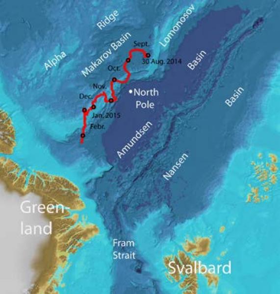
Figure 1, The drift trajectory of the FRAM 2014/15 expedition through the Arctic Ocean deployed at In the Arctic Ocean on 30. August 2014 by the German ice breaker Polarstern.
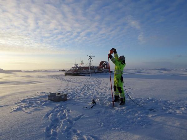
Figure 2: Science Magazine Top 10 Science Images 2014: “Adrift on an ice flow: Home alone for the holidays? It could be worse. Somewhere in the Arctic Ocean, two Norwegian scientists are adrift on an ice floe, equipped with a year’s worth of food and fuel-and one research hovercraft named SABVABAA (pictured). Right now, they’re drifting northward along the submarine Lomonosov Ridge, taking sediment cores to learn about the polar environment more than 60 million years ago.” (Science, 18. December, 2014).
Unique environmental data from the Arctic Ocean are being obtained to provide new knowledge in the following fields of science:
Geology: ca. 800 km of single channel seismic reflection data to explore the geological history of the ridge. Sediment cores (6) to investigate the palaeo-oceanographic environment, including the presence of sea ice during warm climate periods. More bathymetric data to improve our knowledge of the ridge morphology and bottom photography to document life forms on the sea bed.
Oceanography: Current measurements at 2000 and 800 meter depth in the basin and at 1.050 and 800 meter depth over the ridge are the first direct long term measurements of the general velocity field of the contour-following currents along both sides of the Lomonosov Ridge. Measurements of the microstructure in the seawater temperature field were made down to 300 meters depth below the ice during four crossings of the ridge. The objective is to determine upper ocean vertical heat transport over the annual cycle.
Sea ice: Measurements of ice thickness and sea ice conditions has been obtained during the entire expeditions. These data are essential for studies of the sea ice variability and validation of satellite remote sensing measurements of sea ice characteristics in these remote and inaccessible parts of the Arctic Ocean.
Atmosphere: Measurements over the annual cycle of incoming and outgoing radiation to obtain ground truth documentation of the surface heat budget through the full annual cycle in the central Arctic Ocean.
Relevant publication:
Kristoffersen, Y. and J.K. Hall, 2014. Hovercraft as a mobile science plat- form over sea ice in the Arctic Ocean. Oceanography 27(2), http://dx.doi.org/10.5670/oceanog.2014.33