(20 July - 2 Aug.2015)
New web-site: http://sabvabaa.nersc.no for updates
See the web-site: http://www.aari.ru for the Russian ice drift station North Pole - 2015
Ice drift
The hovercraft site drifted 67 nautical miles (124 km) during the two week period (Fig. 1). The separation between the hovercraft and the trailing camp increased to over 20 nautical miles. During the middle of week 48, the hovercraft left the drifting sea ice and parked on landfast ice near Krøyer's Holme. The location is marked with "x" in Fig. 1.
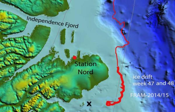
Fig. 1. The drift of FRAM-2014/15 hovercraft during week 47, 20 - 26 July 2015 ( thick red line). Parking location on landfast ice is marked with a black "x".
The ice drift is a result of forces from wind drag and currents. The currents may be both a general background current and tidal currents. The tidal component becomes apparent by a drift trajectory in the form of cycloids at 12 hour intervals when the wind forcing is weak and the steady state currents are slow (Fig. 2).
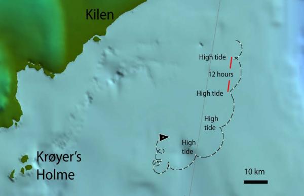
Fig. 2 The drift track 23-27 July 2015 describing nested cycloids.
Sea ice dynamics
The export of sea ice from the Arctic Ocean through the Fram Strait has a minimum during the summer months May through August. At present the main outflow is on the eastern side of the strait as a direct continuation of the Transpolar Drift (Fig. 3). FRAM-2014/15 was deployed on sea ice at a location which under normal circumstances would be included in the Transpolar Drift. The anticipated direct trajectory would be towards Svalbard via the North Pole. Quite unexpectedly, the sequence of cells of low sea level air pressure making their way into the central Arctic Ocean during the winter months resulted in a drift trajectory which gave five crossings of the Lomonosov Ridge and brought the ice camp towards Canada/Greenland. In this region, old ice from the Beaufort Gyre exits the polar basin. On the average, passage of low pressure cells increase sea ice export through the Fram Strait and the export is sensitive to the trajectory of the low pressure. Low pressures moving east of the Fram Strait enhances outflow of ice. This summer, low pressures moving north from Northern Norway towards Svalbard have enhanced the outflow of ice on the eastern side of the strait (Fig. 3).
As shown in Fig. 2 of the report for week 46, a tongue of drifting sea ice accelerated southward after 13 July like a jet stream out of the large ice field to the north (Fig. 3, upper panel). This tongue gradually dispersed as shown by the situation on 23 July 2015 (Fig. 3 lower panel). The distance between the abandoned camp with the stored equipment and the hovercraft increased to over 20 nautical miles (37 km). Thursday 23 July was a clear day and provided an opportunity to compare the satellite information with the ground view. The hovercraft was now drifting in an area where the satellite images indicated scattered sea ice (Fig. 3b). The ground view at the hovercraft site at the same time gave a slightly different impression. The ice surface was rather extensive to the west and north, our directions of prime interest. The picture in Fig. 5 is taken from an airplane a few hours after the pictures in Fig. 4.
At the same time, the location of the abandoned FRAM-2014/15 camp with the stored equipment appeared from the satellite image to be located in a more massive ice field (Fig. 3, upper panel). This is also reflected in the photo overview taken from the airplane (Fig. 6).
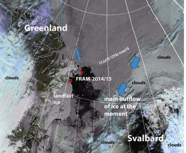
Fig. 3 Satellite image from 17 July 2015 showing the extent of sea ice drifting out through the Fram Strait. Location of the FRAM-2014/15 camp indicated by red "x" and the location of the hovercraft parked on land fast ice indicated by red "o". Note the extensive cover of landfast sea ice along the coast of Northeast Greenland. Satellite image courtesy of the web site http://woksat.info
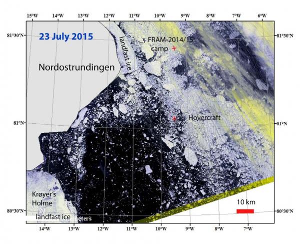
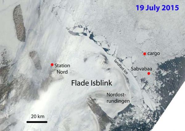
Fig. 3 Upper panel: Ice situation 19 July and the location of the hovercraft and the cargo Lower panel: Ice situation on 23 July and locations of the cargo and the hovercraft Sabvabaa. Krøyer's Holmer where the hovercraft parked on landfast ice 28 July is on the lower left.
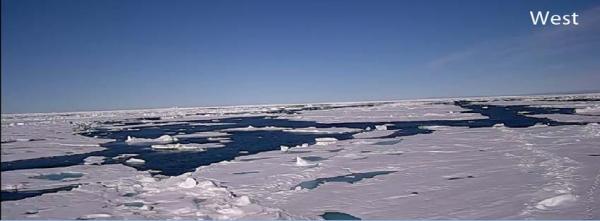
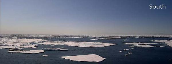
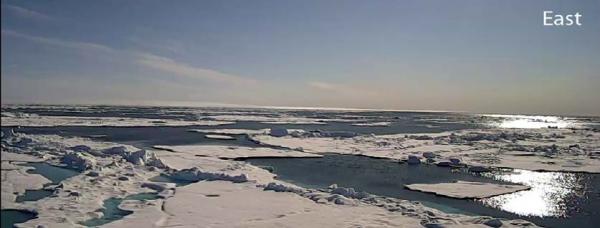
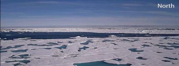
Fig. 4 View of the ice surrounding the position of the hovercraft on 23 July 2015. Photos are taken by a camera on a 13 meter high mast.
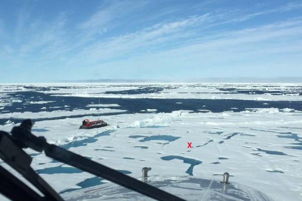
Fig. 5. Overview of the ice floe at the hovercraft site 23 July 2015.. Drop site marked by red "X". Photo courtesy of Pilot Tom-Are Stølsdokken, Lufttransport. View to the WSW.
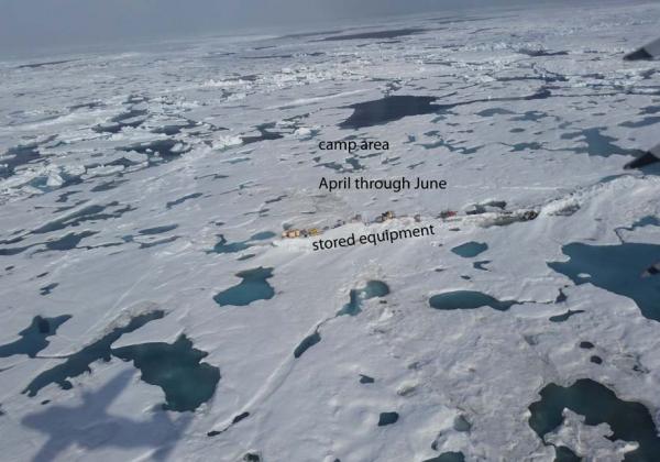
Fig. 6 Overview of the abandoned FRAM-2014/15 camp with the equipment stored on top of a pressure ridge..Photo courtesy of pilot Tom-Are Stølsdokken, Lufttransport.
Camp life
Our time is consumed by keeping ourselves updated on the ice situation and constantly evaluating the advantage of any passing opportunity. We are provided daily with detailed satellite images from the Nansen Environmental and Remote Sensing Centre and position information from the satellite trackers in the abandoned camp. Additional satellite images are available from web-sites such as: ocean.dmi.dk/arctic/ or www.woksat.info/wos.html . The images provide information on ice concentration in a general way, but to convert the image resolution into hovercraft driving conditions is a learning experience. Areas of apparent scattered ice often turn out to be not passable. At this time, the surviving sea ice are mostly fragments of pressure ridges and not level passable areas. Also, because of the limited resolution, the abundance of ice seems to be considerably higher than the images convey.
The hovercraft left the FRAM-2014/15 camp on the July 8th with the intent to reach Independence Fjord and the scientists at the Villum Research Station. The transit was considered to be made up of several shorter segments which reflected the developing opportunities of the ice situation. The first advance was only about 4 nautical miles before the ice conditions did not justify the fuel expenditure. Also, as pitch was applied to the propeller, a rattling sound started when the level increased beyond 2/3 of normal load. Trouble shooting followed in consultation with engineers at Griffon Hoverwork, Southampton. In the end it became clear that the drive axle coming out at the back of the engine had a play which meant the bearing was bad. A pulley at the end of the axle transfers torque to the propeller via a toothed belt. If the axle gives way, the belt slackens, skips positions on the pulley and emits a rattling sound. A spare axle/bearing assembly was held in Longyearbyen and with generous logistic assistance from University of Århus, an airplane was hired to drop the spare part on 23 July (Fig. 7). The cargo landed 30 meter from the hovercraft and ten hours later the replacement had been completed. No test was made as the weather turned bad with 20-30 knots wind and snow for nearly two days. When the propulsion system was tested on the 26 July, a vibration was still there to some extent. A loose engine mount was tightened, but the problem was not completely solved. As a practical consequence, it is not possible to attain normal speed levels over ground; we make 7 knots over water instead of 25 knots. Ice has much lower friction and the disadvantage is less.
The ice concentration to the north of our site continued to suppress any hope for more progress towards Independence Fjord. As the distance between the abandoned camp and the hovercraft site kept increasing and the ice was open to the west, we decided to leave the drifting sea ice and wait it out parked on the landfast ice about 24 miles to the west. In the evening of 28 July, we parked at the very edge of the landfast sea ice (Fig. 8). With that eleven months adrift was temporarily over. It was a moment which called for some reflections and the last glass of red wine available.
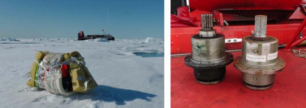
Fig. 7 Cargo with the spare parts received on the ice floe Replacement and used drive axle/bearing assembly (each 15 kilos).
The wide strip of sea ice attached to the coast of Northeast Greenland (Fig. 3) forms in the late fall and completely disintegrates in late July-middle August which means now. At this latitude the present width of the ice belt is over 30 kilometer. The outer part is an amalgamation of shear zones which have the surface expression of parallel ridges of ice blocks. We would have to clear our way to make it farther into the landfast ice. Also, the heavy traffic of dense fields of ice blocks driven by the tide passing along the edge would make it difficult to escape (Fig. 8). We took advantage of the ice conditions on the 31 July and moved north to within 1 kilometer of Krøyer's Holmer (Fig. 2 and Fig. 3, lower panel) and parked on a thick level ice floe. This site appeared comparatively safe (Fig. 8, lower panel).
At this point we are faced with the reality that only about 700 liters of diesel fuel remains. The fuel will be needed for heating and the rendezvous with the relief vessel in about two weeks. Any hope of reaching Independence Fjord has to be abandoned.
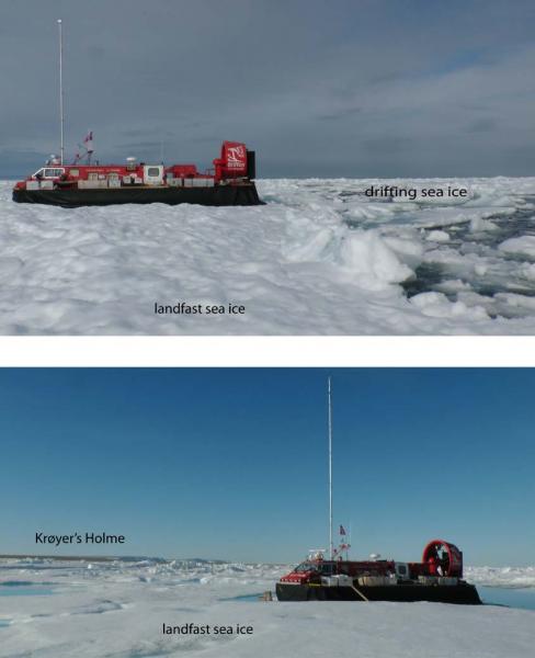
Fig. 8. Upper: First landing on the landfast sea ice 3.1 nautical miles south of Krøyer's Holme. Lower: New location on landfast sea ice 0.5 nautical mile from Krøyer's Holmer.
Temperatures during the past two weeks have been in the range -1°C to +3 °C. Week 47 had a single day of clear sky (Thursday 23 July), the rest was low clouds and near white-out conditions. The two last days of week 48 (01 and 02 August) were glorious - a low dense cloud cover dominated the rest of the week.
Space technology and the field office on sea ice
Being able to communicate with the outside world is crucial to any activity in remote areas. Having had the good fortune of getting the experience of the life of a scientist on the ice (1979 and 1982) in the era of HF-radio communication, I fully appreciate the importance of the satellite communication facilities of today. The challenge with HF-radio communication is the highly variable ionospheric conditions. As an employee of the Norwegian Polar Institute at that time, I had access to a powerful transceiver and could communicate directly with Svalbard Radio on the same frequencies as the fishing fleet. The main camp communication was via HF to Station Nord, or phone patches to the United States using the radio amateur band.
Today, there is precious little difference between what you can effectively achieve working out of your regular office and a High Arctic field office as the FRAM-2014/15 ice drift. The satellite phone and access to internet are on your desk. Although, the Iridium satellite communication system with its limited bandwidth has constraints, it is fully functional for the majority of tasks. The daily routine apart from regular e-mail correspondence, includes downloading satellite images to follow the sea ice conditions, air pressure charts and checking the weather forecast.
Most importantly, it makes it possible for us to independently handle matters arising with the same efficiency as being at your home institution. A recent example was the need for getting a spare part over from Longyearbyen two weeks ago. Options were explored in e-mail communication with the logistic support group (Aarhus University) for the Villum Research Centre at Station Nord. We then asked our home institution (Nansen Environmental and Remote Sensing Centre, NERSC) to transfer the money to hire a plane, and the air drop was carried out the day after. Throughout the year, crucial support has been given on computer issues by key NERSC staff by directing us through the problem via the satellite telephone. A team of engineers at Griffon Hoverwork, Southampton responds instantly via e-mail with advice on problems arising with the hovercraft. As a result, the quality of the communication facility compensates to a considerable extent for the need to have one person for every task on the ice, an issue which relates to safety as well as costs.
Another aspect is the fact that it is also possible to continue your scientific publishing activity from a remote sea ice site in the High Arctic. In our report for week 8, we mention the submission and completed final revision of our paper to Journal of Geophysical Research where we report the results of two seasons of vibroseis exploration of the sub-ice geology in Dronning Maud Land. This is a first on the Antarctic continent using the vibroseis technology and another joint cutting edge science venture with our German colleagues.
Validation of satellite imagery is an important topic of research. One aspect is the portrayal of the sea ice concentration in images of limited resolution. This is an issue which has great practical importance for us at the moment. As shown in Fig. 4, we collect ground photo documentation of the actual sea ice conditions in the marginal ice zone with a foot print of about 4 square kilometers.
Science
With a reduced crew and frequent relocations, we have terminated the ice drift science program as a safety measure .
Wild life
A young polar bear made a brief visit, but instead of going for the food box above his head on the deck, the bear bit a hole in the hovercraft skirt and was subsequently scared away by the sound of the engine.
The difference in abundance and diversity of the bird life between our present location and the west coast of Spitsbergen, is striking. We have daily visits by a few single individuals of Iceland gulls. On Saturday 01 August, we got a surprise visit by five large birds, tentatively identified as Common Eider in late summer plumage (Fig. 9 and 10). They rested peacefully at the ice edge near the hovercraft before continuing.
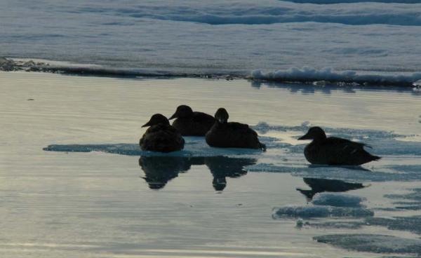
Fig. 9. Common Eider? in late summer plumage.
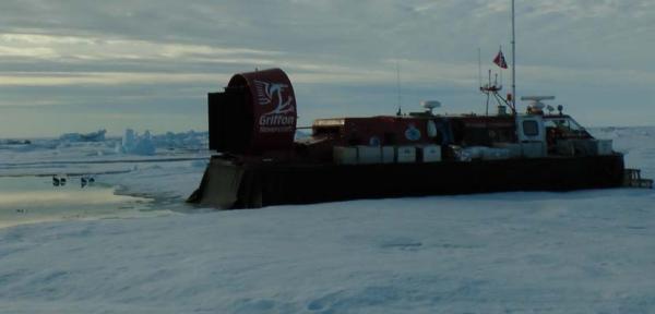
Fig. 10. Common Eider? In the left background.
Life in the High Arctic treats me well.
Yngve Kristoffersen
Daily reports
Monday 20 July
Position: 81° 27.75' N, 10° 10.4' W, temperature 0 °C, air pressure 1025 hPa, wind 9 knots from the N. Ice drift 0.4 towards the S. Overcast all day. A polar bear suddenly put his paws on the front window, but took off as the engine was started. The radar shows land is 14 nautical miles away. Awaiting satellite images to decide what to do next. Dense cloud cover render only synthetic aperture radar (SAR) images useful.
Tuesday 21 July
Position: 81° 19.66' N, 09° 44.4' W, temperature 1 °C, air pressure 1022 hPa, wind 6 knots from the WSW. Ice drift 0.2 knot towards ESE. Low clouds all day. We are now isolated on a floe 200 x 300 m with about 100 meter of open water on three sides. Beyond that is solid ice all around. Danish Air Force C-130 flight to St. Nord was cancelled and hire of an airplane was necessary in order to get the spare axle/bearing from Longyearbyen. Hire was arranged through an agreement Univ. of Århus has for science support flights from Longyearbyen to St. Nord.
Wednesday 22 July
Position: 81° 15.00' N, 09° 29.6' W, temperature -1 °C, 1023 hPa, wind 3 knots from the ENE. Ice drift 0.35 knot to the SE. Rain in the morning, clearing up at noon and a glorious afternoon and evening. The ice floe has rotated 180 degrees during the last 24 hours. Hire for the air drop of the spare part was finalized and scheduled for tomorrow to take advantage of the weather conditions.
Thursday 23 July
Position: 81° 06.31' N, 09° 14.8' W, temperature +1 °C, air pressure 1022 hPa, wind 7 knots from the N. Ice drift 1.0 knot towards the S. At about 1600 hours the Dornier airplane piloted by Tom-Are Stoelsdokken dropped the spares from about 30 meter altitude. The well wrapped box landed 30 meter from the hovercraft and its content was in good order. The aircraft made a search for the abandoned camp site with the stored equipment, photographed the site and returned to Longyearbyen. Started the job with replacement of the axle/bearing assembly at 2000 hours. The work went without significant obstacles, the drive belt was put on and tightened to specifications.
Friday 24 July
Position: 80° 51.30' N, 09° 26.5' W, temperature -2 °C, pressure 1016 hPa, wind 25 knots from the N. Ice drift 0.9 knot towards the S. Snow and 20-30 knot winds from the early morning. Work on the propeller drive unit went on until 0330 hours, but no testing done. During the day, all open water areas closed and there was one solid ice cover in all directions. The stove would not burn properly - the temperature in the cabin went down to +9 Centigrades
Saturday 25 July
Position: 80° 45.76' N, 10° 35.5' W. Temperature -1 °C, air pressure 1014 hPa, wind 12 knot from the N. Ice drift 0.2 knot towards the ESE. Overcast and rain during the afternoon and evening. The ice floe has rotated 360 degrees during the last 24 hours. The abandoned camp with the equipment is now 18.8 nm away.
Sunday 26 July
Position: 80° 45.89' N, 10° 50.9' W, temperature 0 °C, air pressure 1018 hPa, wind 5 knots from the WSW. Ice drift 0.4 knot in a cycloid motion. to the S. Light snow, fog. Tested the forward thrust. Surprisingly, the vibrations are still there as pitch is applied beyond a certain level. Change of the axle/bearing assembly gave improvement, but did not solve the problem.
Monday 27 July
Position: 80° 49.83' N, 10° 53.3' W, temperature 0 °C, air pressure 1020 hPa, wind 8 knots from the SSW. Ice drift 0.6 towards the NE. Overcast and fog all day. Pursued the engine problem. Rear starboard engine mount was loose and the bolts were tightened. The stove was unhappy and would not burn properly because the hovercraft had a list in its parking position. Had to reposition the lumber under the keels.
Tuesday 28 July
Position: 80° 53.68' N, 11° 01.7' W, temperature -1 °C, air pressure 1022 hPa, wind 11 knots from the WSW. Ice drift 0.4 knot in a cycloid pattern. Fog is coming and going. Started driving the hovercraft at 1015 hours towards the west to reach the landfast ice. After two hours the hovercraft suddenly got a list which could not be corrected by the skirt control and the craft was parked on an ice floe for inspection. A pivoting angle which was part of the skirt control had got stuck. The problem was corrected and the journey continued. The fog made it difficult at times to avoid dead ends. Most surprising was recognition of the conflicting impressions of the real ice conditions compared to conditions derived from the satellite images due to the limited resolution. At 2048 hours we reached the edge of the landfast ice and parked about 3.1 nautical miles southeast of Krøyer's Holmer. The sea was dead calm, but the fog was dense all evening. This moment marked the end of 11 months on the drifting sea ice. The occasion was celebrated with a moment of reflection, Drytec Minestrone soup (just add hot water) and a glass of the last red wine from the Polarstern collection. Land is seen on the radar at 16 nautical miles and Krøyer's Holme at 3.1 nautical miles.
Wednesday 29 July
Position: 80° 36.50' N, 13° 24.1' W, temperature -2 °C, 1020 hPa, wind 7 knots from the NE. Low clouds and poor contrast until the afternoon, good visibility in the evening. We are parked at the very edge of the landfast ice. Put the hovercraft upon wooden planks to avoid melting. Checked out possible sites for better parking, but the flat areas are small and too narrow for maneuvering. A young polar bear appeared in the evening and started biting the hovercraft skirt below the food box on deck. Made a 10 cm long tear. Started the engine and the bear run away.
Thursday 30 July
Position: 80° 36.50' N, 13° 24.1' W, temperature -2 °C, air pressure 1026 hPa, wind 8 knots from the ENE. We are parked at the edge of the landfast ice. Worked on illustrations all day. Danish Air Force Challenger surveillance plane was overhead at 1400 Z, and on return at 1630 Z made a low pass over our abandoned camp site at 80° 54.69' N, 12° 01.0' W (1200 Z) and took photographs.
Friday 31 July
Position: 80° 38.05' N, 13° 34.9' W, temperature +3 °C, pressure 1028 hPa, wind 3 knots from the S. The parking site on the landfast ice was only meters away from the edge with heavy "traffic" of large pieces of drifting sea ice driven by the tide all along the edge. If a break- off occurred, it would be difficult for the hovercraft to proceed under these circumstances. At 0200 Z, we took advantage of open water along the edge and the calm weather to move towards the north and parked at 80° 37.83' N, 13° 34.55' W on 80 cm thick landfast ice. At 1100 Z, we suddenly discovered we were moving, and relocated again to 80° 38.05' N, 13° 34.9' W to a very thick floe. The position is less than 1 km from the eastern tip of Krøyer's Holmer. Worked on reporting the rest of the day.
Saturday 01 August
Position: 80° 38.05' N, 13° 34.9' W. Temperature 0 °C, air pressure 1029 hPa, wind 8 knot from the NNE. Parked on landfast ice. A glorious day. The drift ice is a solid pack within the entire field of view. Worked on the weekly report. Five Common Eider rested 5 m from the rear of the hovercraft in the morning.
Sunday 02 August
Position: 80° 38.04' N, 13° 34.9' W, temperature +7 °C, air pressure 1025 hPa, wind 3 knots from the SW. Parked on landfast ice. A glorious day. Moved the hovercraft a few meter and put wooden planks under to avoid melting in. Dense drift ice as far as we can see. Worked on the weekly report.