(29 Sept. - 06 Oct. 2014)
Ice drift and camp life
The motion of the vast fields of sea ice in the Arctic Ocean is mainly driven by the surface winds. Passing low pressure systems are associated with strong and changing winds and this is certainly why our fifth week on the ice became more eventful than appreciated. The intense low pressure that passed Northern Norway in the early hours of Saturday 27 September, reached Franz Josef Land the next day and moved onwards to the North Pole where it remained stationary for almost 3 days. The wind speed in our area increased to 26 knots (ice drift 0.5 knots) by midnight on Sunday, reached 42 knots on Monday morning (ice drift 0.8 knots) and remained over 30 knots (ice drift 0.5 knots) for the next 24 hours. Drifting snow made outside work impossible. The high winds from East and South-East deposited a snow bank on the upwind side and two, about 70 meter long drifts on each side of the ice hangar. By coincidence, the position of one of the flanking drifts buried our outside storage area for equipment. Our conservative estimate of excess volume of snow is about 700 cubic meters which represents a load of about 200-250 tons, i.e. more than five times the weight of the ice hangar and the hovercraft. Relatively warm air with temperatures in the range minus 8 to minus 5 Centigrades persisted from Saturday 27th through Thursday October 2nd and kept the sea ice cover weak .The response of the visco-elastic ice sheet to the extra load was subsidence which implied 10 cm of sea water on top on the ice by Monday. By Tuesday the increase in water level relative to the ice surface reached 45 cm since the start of construction. Normal rubber boots were not high enough and survival suits were needed to move around. Our first priority was to get our equipment (estimated at 3 tons) out of the snow and water and move it about 30 meter. We also needed to temporarily move the hovercraft out of the hangar, otherwise the skirt would freeze in. The hovercraft was parked at a new site 50 meter away, a new 1 m x 1 m hole was made through 1.5 meter of ice and the work tent put up over the hole. By Saturday, we had overcome most of the disruptions, but will in the near future have to contend with poorer working conditions and exposure to the wind chill. At this point, the ice drift had brought us within 6 nautical mile of the 3000 meter contour at the foot of slope on Lomonosov Ridge and temperatures dropped to minus 18 Centigrades. We still had cold related work challenges to sort out in order to be ready for the geological work. It has been a busy week and we are still in the start-up phase. Officially, our working day has to some extent followed the time zone of our position in order to maximize the remaining amount of daylight. However, in reality it is floating through all time zones depending on what needs to be done and at what time your body signals; now it is more than enough. In about two weeks, we expect the 0.5 meter thick water layer on top of the ice will be frozen solid and we can move back into the ice hangar and settle in.
So the lesson from this week is that the weight you put on the ice is one thing, what really matters are the aerodynamic consequence of the obstructions you make.
Science
The autonomous oceanographic instruments which include an acoustic Doppler depth profiler (0-500 m) and two current meters hanging from the ice (800 and 2000 m depth), are running. The surface instruments are the weather station and instruments for measuring radiation fluxes.
On Sunday, we started on the initial calibration run with the thermistors for the turbulence measurements, but aborted due to problems with the meter wheel.
Ocean depth is measured by a drifting array of echo sounders over a 6 km distance formed by the 3.5 kHz echo sounder suspended through the hydro hole by the hovercraft and 5 autonomous buoys. On approach to the foot of slope of the Lomonosov Ridge, we observe strong lateral amplitude variations in the upper 20 m of sediments penetrated by the 3.5 kHz echo sounder. This may be due to sheets of sandy sediments sourced by small mass wasting events on the sediment starved slope of Lomonosov Ridge. In contrast, the signal amplitudes of the echo return over the abyssal plain farther out in the Makarov Basin showed great lateral continuity.
The seismic reflection measurements was in operation from the afternoon on Saturday 27 September using a 0.3 litre air gun and recording with a single hydrophone. Sub-bottom penetration was about 2 km. The ice drift increased from 0.2 knots to 0.8 knots in the high winds in the early hours on Monday morning and to maintain one shot point every 25 meter, the airgun fired at 70 second intervals. At every shot, about 40 liters of air (pressure 1 atmosphere) is released into the water. At the high drift rate, we observed that all the released air missed the hole in the ice 5 meters above. Instead of venting through the hydro hole, the air gets trapped and accumulated somewhere else below the ice. Some air will leak out, but a sub-ice air cushion will change the local stress field which in turn may become an attractor for regional ice crack propagation. In the past, use of airguns have been blamed for ice camp break-ups, but the relation is probably in the category of myths. Cracking of the ice floe and lead formation does by no means represent a danger, but is an inconvenience. We pulled the gun up to 2 meters below the ice and the same thing happened. At this point, we stopped shooting.
No form of animal life has been observed during the week.
All is well.
Yngve Kristoffersen & Audun Tholfsen
Daily reports
Monday 29 September.
Position: 87 57.5' N, 175 57' E, temperature - 8 C, air pressure 997 hPa, wind 32 knots from E. Ice drift 0.8 knots towards NNE. Water depth is 3998 meter. Stopped shooting the air gun as the released air did not hit the hole in the ice, but deflected and accumulated somewhere else under the ice. Water level in the hangar has risen 10 cm since yesterday. Have to use the survival suits to be able to move around. Worked to free frozen-in parts of the hovercraft skirt now under water.
Tuesday 30 September.
Position: 88 11.6' N, 179 50' W, temperature - 5 C, air pressure 992 hPa, wind 27-32 knots from E. Ice drift 0.5 knots towards northeast. The water level has risen another 20 cm during the last 24 hours, total change is 45 cm. Increases have been stepwise and during periods of high winds. Snow drifts have formed upwind from the ice hangar with two about 70 meter long ridges (crests at 1.5 m above the ice) on either side and enlarged earlier smaller accumulations. A rough conservative assessment of excess snow volume gives a figure of about 700 cubic meters which has a weight of about 200-250 tons. The area of visible water on the ice is elongated as the area covered by the snow ridges. Moved the generator one pallet higher.
Wednesday 1 October.
Position: 88 20' N, 176 28' W, temperature - 5 C, air pressure 1003 hPa, wind 3 knots from ESE. Ice drift 0.2 knots towards northeast. The wind calmed down in the morning. Started excavating equipment and food suppplies from the snow drift. Our day has changed a bit; had dinner at 0600 hours and went to bed at 0800 hours. Woke up and started a new day at 1530 hours. Moved equipment and food from the water-logged snow drift to a small ridge about 30 m away.
Thursday 2 October
Position: 87 26' N, 168 04' W, temperature - 7 C, air pressure 1018 hPa, wind 9 knots from ENE. Ice drift 0.2 knots towards NNE. Worked from midnight to 0900 hours with moving our equipment to the new location. Had dinner at 0900 hours and went to bed at 1200 hours Started again at 1800 hours. Checked radiation flux instruments for snow and ice.
Friday 3 October.
Position: 87 29.5' N, 175 23' W, temperature - 10 C, air pressure 1023 hPa, wind 10 knots from NNE. Ice drift 0.1 knots towards NNE. Started preparation for moving the hovercraft to a new location. Had to use survival suits because of the water level in the ice/snow building. Backed the hovercraft out from the ice hangar
and parked about 50 meter away on pallets. Noticed sudden loss of lift and established that the lift fan belt was broken. We are now exposed to the wind chill during all work outside the cabin.
Saturday 4 October.
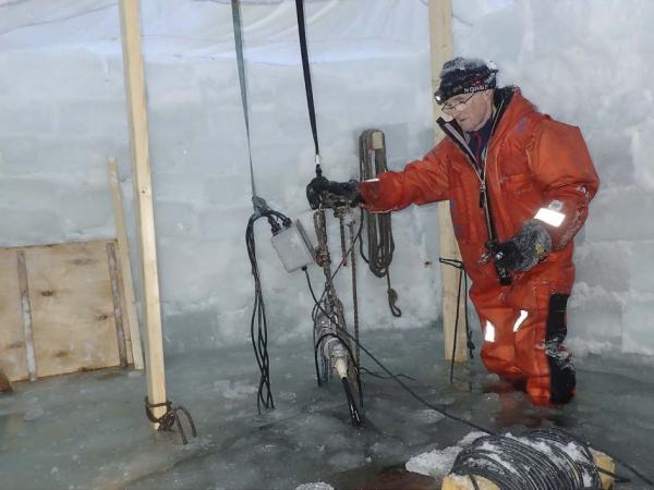
Position: 87 33.2' N, 176 14' W, temperature - 13 C, air pressure 1035 hPa, wind 4 knots from the N. Ice drift 0.2 knots towards NE. We are 6 nautical miles from the 3000 meter depth contour for Lomonosov Ridge. Audun made a hole 1m x 1 m through the1.5 meter thick ice. We put up and attached the work tent to the hovercraft.Moved geological equipment into the tent. All items were full of ice and snow. A heated box had to be made to thaw out everything.
Sunday 5 October.
Position: 88 34.5' N, 176 39' W, temperature - 14 C, air pressure 1035 hPa, wind 2 knots from N. Ice drift 0.1 knot towards ENE. Worked on mounting the hydraulics for the winch. The winch and all hoses had to be thawed out. Started calibration run for the string of the sea water temperature loggers, but aborted due to problems with the meter wheel. Had problems with the signal from the 3.5 kHz echo sounder transducer, but the signal came back - the cause of the problem remains unexplained. The water depth is 3988 meter
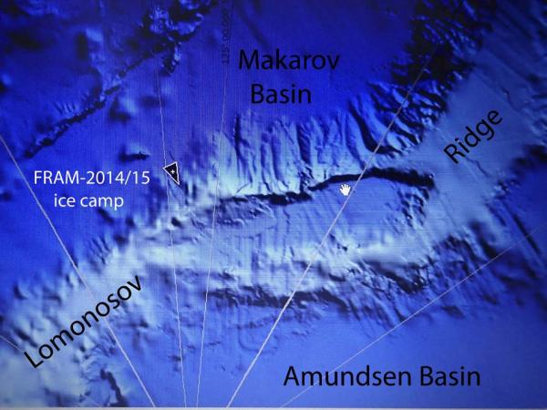
Position of FRAM-2014/15 (black triangle) as of Sunday 6 October.
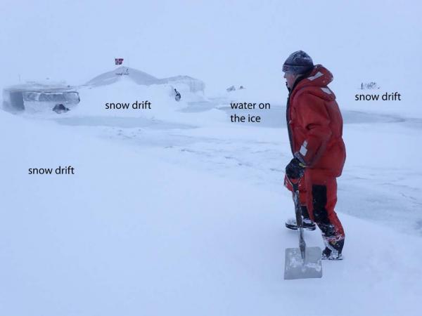
Snow drifts formed on both sides of the ice hangar and on the up-wind side in the back (not seen).
Photo: Audun Tholfsen
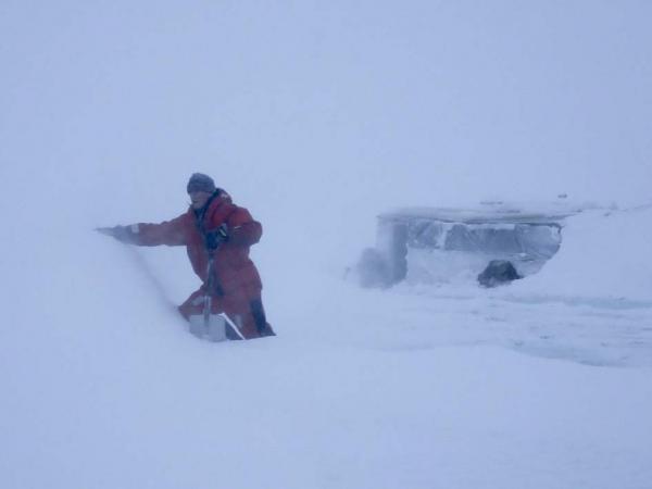
Scaling the snow drift on the east side of the ice hangar. Photo: Audun Tholfsen
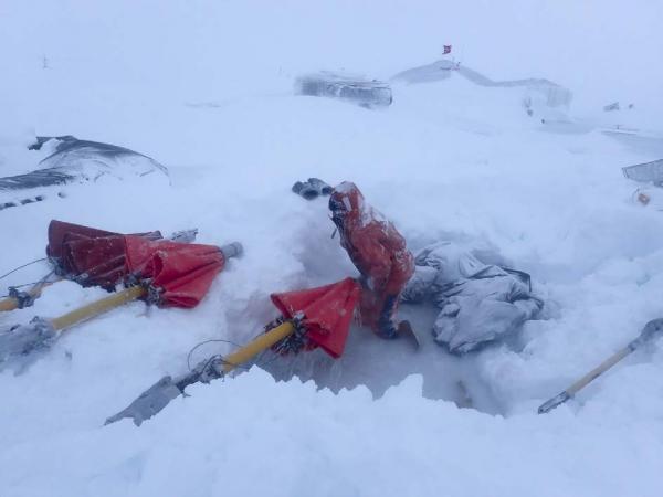
Digging out sediment corers from the snow drift and the lower half meter of water logged snow. Photo: Audun Tholfsen
Deploying the airgun in the flooded hydro hole. Photo: Audun Tholfsen