(06 - 13 Oct 2014)
Ice drift and camp life
The ice camp has drifted about 27 nautical miles (50 km) to the northnorthwest during the week. The weather situation has been characterized by a persistent high pressure, calm winds, but low temperatures reaching minus 26 on Friday morning. Being temporarily forced away from the ice hangar, the hovercraft is now unprotected against the wind chill where temperatures reached minus 35 Centigrades several times this week. Inside the cabin we have a comfortable 20-27 Centigrades, and the condensation problems are eliminated by covering parts of the superstructure with insulating Glava winter mats, normally used for temporary protection of a worksite during construction. However, outside working conditions are demanding. Audun has built a small lee wall around the work tent to provide some protection. The hydraulic winch and take-up drum work fine under these conditions, but it is clear that it is not practically feasible for us to rig the hydrostatic corer under these tough circumstances; in the more spacious ice hangar yes, but not here. We have had to stay with a smaller gravity corer and the dredges. We expect to move back into the hangar in a week or so and have measured the ice thickness by drilling several places; in most cases the ice appears to be 1.5 meter thick.
On Sunday 13 Oct. we were drifting over the intra-ridge basin plain in 2500 meter water depth shooting seismic reflection and things were running well. At this point we declared Sunday a day of rest; the first of its kind since Polarstern left us six weeks ago.
Science
Having partly recovered from the disruption cause by the weather situation the week before last, we finally deployed Ilker Fer's 300 meter long vertical array of 30 thermistors . First a calibration run was made. His motivation is to quantify processes leading to vertical transport of oceanic heat; how efficient is oceanic heat transport for melting the ice?. The thermistor string combined with the acoustic Doppler current profiler enable characterization of the background internal wave field. Ilker Fer has made short visits (2006-2008) to the Russian ice station Barneo at 89 North to carry out similar experiments including hiring a helicopter to obtain ocean microstructure across the Lomonosov Ridge. The presence of the large Lomonosov Ridge could possibly enhance vertical mixing processes. The FRAM-2014/15 deployment which traverses the Lomonosov Ridge and continues more than 1000 km towards the Fram Strait, will greatly enhance his observational data base.
The autonomous oceanographic instruments; an acoustic Doppler depth profiler (0-500 m) and two current meters hanging from the ice (800 and 2000 m depth), are running. The surface instruments are the weather station and instruments for measuring radiation fluxes.
Ocean depth is measured at six locations within a 6 x 6 km area by the echo sounder at the camp and 5 autonomous buoys reporting via Iridium.
We were concerned that the deep (2000 m) current meter would hit bottom where the Lomonosov Ridge topography shallowed to about 1100 meters. The Kevlar line going through the ice was protected by a 2 meter long orange plastic tube picked up from the road side in Longyearbyen. Audun poured 3 liter of hot water into the tube and it was freed from the ice in no time. Reminiscent of Nansen's men pulling the sounding line over their back, we man hauled the 2 km line with the current meter at the end for about 150 meter to connect up with the geology winch at the hovercraft. The current meter was then lifted to 1050 meter depth and will be lowered again once the ridge is passed.
The main objective of FRAM-2014/15 is geology. The original plan targeted Alpha Ridge which represents a vast area with many known and unknown localities for recovery of Mesozoic sediments. Earlier ice drift observations suggested the ice camp would stay within the area of interest of the order of several months to half a year and even more. As the icebreaker was not able to reach the fringes of Alpha Ridge, Lomonosov Ridge became the alternative, and it presents a raw deal. As the drift direction is directly across the ridge, potential targets would be present over a drift distance of only 12 nautical miles which would be covered in 2-3 days. Beyond that, no second chances! There are only a few hours of twilight at local noon, and it is too risky to drive upstream to look for second chances at this time of the year.
Our drift path crossed the Lomonosov Ridge where an intra-ridge basin is preset. As we passed the 3000 m depth contour on our way upslope, we inferred the presence of steep inclines from multiple diffraction hyperbolae. We deployed the small gravity corer, which must have hit something hard as the recovery was a mere 5 cm of sediments beyond the core catcher. We then lowered the dredge in 2324 meter water depth. We lifted off the bottom 2.5 hours later, but it came up empty. Passing the ridge crest, we attempted another dredge haul in 1383 meter water depth and let it stay down until the water depth increased to 1690 meter. The recovery was only two fist size rock specimens which may just be glacial erratic. From the echo sounder record no outcrops were encountered down slope into the intra-ridge basin.
The operational cold problems with the seismic reflection measurements were overcome and now run smoothly. We keep heat on the compressor at all times and pump air at two hour intervals to prevent the hydraulic oil driving the compressor from being too cold. Sub-bottom penetration in the intra-ridge basin (2500 meter water depth) is over 3 seconds (> 3 km) two-way travel time using a 0.3 liter (20 cuinch) airgun and recording the signal from a single hydrophone.
Audun observed fresh tracks of one adult and one or possibly two cubs near the camp on Friday. They kept at a distance probably due to the noise from the generator.
Life is treating us well beyond the trivial problems of the cold environment. We have passed 89 degrees North and the direction of drift is more or less due north.
Yngve Kristoffersen & Audun Tholfsen
Daily reports
Monday 6 October.
Position: 88 36' N, 176 15' E, temperature - 13 C, air pressure 1038 hPa, wind 3 knots from NNE. Ice drift 0.1 knots towards northnortheast . The 3000 m Kevlar line had so far only been hand spooled onto the take-up drum and left about 150 m of line which did not fit. We had to redo the job, but now with a small weight and all 3000 m in the water. The drum was originally designed to be laid down horizontally in deck to distribute weight, but we started off with using it in a vertical position as spooling became more convenient. This was a mistake because of the pressure exerted on the sides. As a result, it took the whole day to get the job done. Completed calibration down to 300 m depth of Ilker Fer's thermistor chain.
Tuesday 7 October
Position: 88 39' N, 177 03' E, temperature - 16 C, air pressure 1041 hPa, wind 8 knots from NNW. Ice drift 0.2 knots towards NW. Prepared a small gravity corer for the first coring run to be made. We have so far during the whole 6 weeks on the ice been in water depths beyond the reach of our 3000 m long kevlar line. We passed the 3000 m contour by mid-day. At 1900 hours, the corer hit bottom in 2470 m water depth. It came up with only 5 cm of brown mud behind the core catcher - we must have hit something hard and the 3.5 kHz echo sounder showed a confused pattern of diffraction hyperbolae. All sensors on the weather station completely covered with rime - removed all. On the radiation flux instrumentation, the sun time sensor was covered with rime and IR sensor with snow - remove all.
Wednesday 8 October.
Position: 88 44.6' N, 178 26' E, temperature - 15 C, air pressure 1028 hPa, wind 14 knots from N. Ice drift 0.2 knots towards NW. Based on the anticipated hard bottom from the coring attempt and the 3.5 kHz image of the seabed, we lowered the dredge in 2325 meter water depth. Increased ice drift gave a wire angle and during ascent the Kevlar line cut into the side of the hydro hole. When the dredge came up under the ice we could not recover it, but could see that it was empty. We had to cut the line and leave the dredge until time allowed recovery. As the water depth shallowed relatively fast, our immediate concern was the current meter hanging from the ice at 2000 meter depth would soon hit the bottom topography. The Kevlar line had a plastic tube ( 2 cm diameter) protection through the ice and with 3 liters of hot water it came loose. We man hauled the line the first hundred meter and hooked on to the geology winch. Raised the current meter (10909) to 1050 meter and
secured. The job took 4 hours. Deployed Ilker Fer's string of 30 thermistors, one for every 10 meter down to 300 meter depth.
Thursday 9 October.
Position: 87 47.4' N, 177 01' E, temperature - 14 C, air pressure 1020 hPa, wind 6 knots from the NNE. Ice drift 0.2 knots towards NW. Lowered the dredge in 1383 meters of water - put out 2000 meter of line. Kept the dredge out until 1690 meter water depth ten hours later and recovered. The dredge was 1/3 full of brown mud and two fist sized rock specimens; one angular and one rounded. The Knudsen 3.5 kHz echo sounder signal disappeared in the morning. We can hear the trigger signal at all four transducers, but no power. Put in the 12 kHz transducer instead. The output signal also weakened after a while. Sounds like we have a short somewhere, but unable to locate exact spot in the electronics. Prepared a heated enclosure for the compressor.
Friday 10 October.
Position: 88 50' N, 177 21' E, temperature - 19 C, air pressure 1017 hPa, wind 4 knots from N. Ice drift 0.1 knot towards NNW. Minimum temperature during the night was .26 Centigrades. Started shooting seismic after preheating oil reservoir and compressor. The compressor is kept heated at all times and if we refill air at least every two hours the oil for the pump keeps sufficient temperature without preheating every time it is used. We have now descended the southern rim of the intra-ridge basin and are at the foot of slope. The water depth is about 2400 meter and the seismic signal has a sub-bottom penetration over 3 seconds. Audun discovered polar bear tracks near the camp; one adult and one or two cubs. They had wandered around by our fuel storage area, and ignored the food stored nearby probably frightened by the sound of the generator.
Saturday 11 October.
Position: 88 54' N, 177 22' E, temperature - 23 C, air pressure 1017 hPa, wind 7 knots from N. Ice drift 0.1 knot towards N. Shooting seismic continuously. A horrible 50 Hz noise signal appeared, and the source was most likely the generator which we need on continuously. We grounded the lines at both ends and the problem disappeared. Audun restored continuous power for charging the battery of the radiation flux measurements. The power had been interrupted when we moved out of the ice hangar. Cleared rime and snow from the weather station. At the radiation flux site, the sun time detector was covered with rime and the IR detector with snow while the radiation detectors were fine.
Sunday 12 October.
Position: 88 58.6' N, 175 47' E, temperature - 19 C, air pressure 1015 hPa, wind 10 knots from N. Ice drift 0.2 knot towards N. Shooting seismic reflection continuously. We pump
the 40 liter air reservoir up to 200 bar every two hours. A constant 130 bar pressure on the airgun is maintained via a pressure reduction valve. All instruments work well. As we are over a deep plain and the operation runs well, we declared Sunday as a day for rest - the first in six weeks. We passed 89 degrees north by mid-day and the drift direction is near due north.
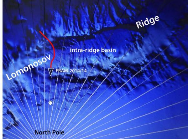
Drift path of FRAM-2014/15 during the sixth week on the ice
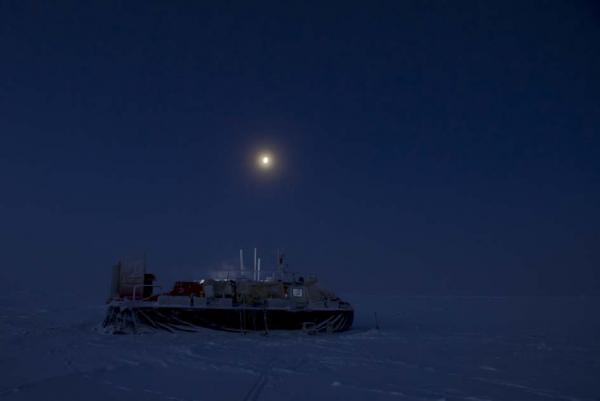
Current location about 50 meter from the ice hangar
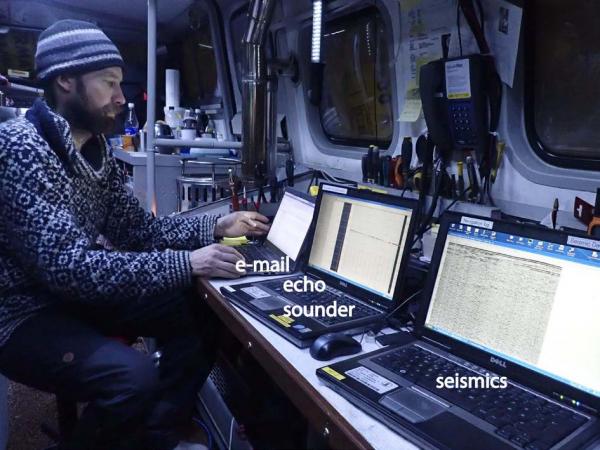
The data logging system onboard Sabvabaa
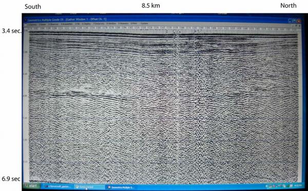
Screen shot from seismic data acquisition across the intra-ridge basin.