
(20- 27 Oct. 2014)
Ice drift
The ice camp moved about 35 nautical miles (65 km) during the week (Fig. 1) and of all things brought us back across the Lomonosov Ridge - what more could we ask for?. This was a result of a very pronounced high pressure over the Arctic Ocean from the North Pole towards Alaska and must have expanded the Beaufort Gyre. This ice motion was augmented from Wednesday on by a low pressure trough which extended up from the Fram Strait. We drifted across Lomonosov Ridge and a few kilometers into the abyssal plain in the Makarov Basin, before the drift weakened and we turned back towards the ridge on Saturday. This development was a huge bonus to us, because it gave us new possibilities and three crossings of the ridge rather than one. A similar drift path was experienced by the legendary Russian ice drift station NP-28 which operated over 2.5 years from an ice floe and crossed Lomonosov Ridge three times in 1987.
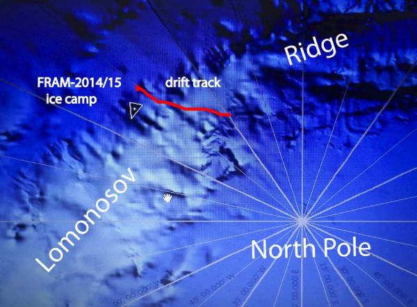
Fig. 1 Drift track of FRAM-2014/15 across Lomonosov Ridge during week 8
Sea ice dynamics
The ice has been relatively calm all week, although Audun discovered a new crack which became 3 meter wide about 5 meter away from the back of the hovercraft. After a while it closed with some shear motion and has since been quiet. We watch the situation closely, some cracks may represent a potential problem, others not, even if they are close. The dilemma is that relocation takes time; we are here to do science, and prefer to wait and see rather than jump for every new crack in the neighborhood. We have to be ready when we pass a potential target on the seabed, otherwise the opportunity is lost.
Camp life
Since we now have complete darkness, we have drifted back to follow Norwegian time. However, our day is determined by what we see on the sea floor and what action is needed. Sometimes the ice drift is 200 meter pr. our or less. You get a feeling of having plenty of time as you will not be home for Christmas anyway. Doing seismic reflection measurements 24 hours a day creates a special routine. Depending on the drift rate, a bang goes off in the water 3 meter below the ice every 2-6 minutes and the hovercraft shakes. Your sleep cycle now becomes determined by the need to run the compressor every two hours 24/7. As a reward, your PC screen gives you a visual presentation of the acoustic layering in the sediments up to 2 km below the seabed.
We survive well because Audun is doing the cooking. Fish and meat alternate for dinner during weekdays. Saturdays are reserved for porridge (risengrynsgrøt).
Science
We are overseeing the following suite of continuous measurements:
Bathymetry and sub-bottom profiling:
- five autonomous echo sounder buoys reporting to shore via Iridium
- seismic reflection (0.3 litre air gun & single hydrophone), sub-bottom penetration ̴2 km
Oceanography:
- Acoustic Doppler Current Profiler 0- 500 meter depth
- two Aanderaa current meters at 800 and 1050 meter depth, respectively.
- thermistor string with 30 thermistors from the surface to 300 meter depth.
Atmosphere:
- measurement of incoming and outgoing radiation from the ice surface
- surface infrared skin temperature
- sun time
- Aanderaa weather station (wind, temperature and humidity)
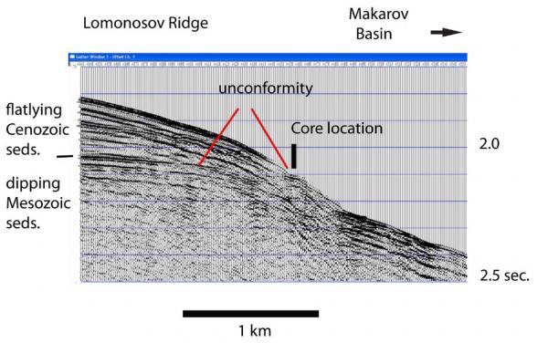
Fig. 2. Seismic section across upper Makarov-facing flank of Lomonosov Ridge showing core location. The bubble pulse in the seismic signal is very pronounced when shooting under a flexuring ice sheet.
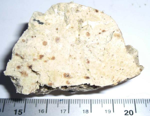
Fig. 3 Sediment recovered at the unconformity at the base of the Cenozoic section.
The seismic reflection measurements are running really well and are our main tool in the search for bottom sampling targets . Sub-bottom penetration is sometimes over 2 sec. two-way travel time (c. 2 km). Coming over the top of Lomonosov Ridge, we recognized in the seismic data the key features of the sediment cover on the ridge; a c. 300 meter thick upper section of flat lying sediments resting with an angular unconformity on underlying stratified rocks (Fig. 2). Scientific drilling on Lomonosov Ridge in 2004 showed the upper section to be younger than 56 million years. We dropped the sediment corer where we saw the potential for exposure of rocks below the unconformity and got 20 cm of very cohesive, light cream colored sediments - something we have not seen so far from the Arctic Ocean (Fig. 3).
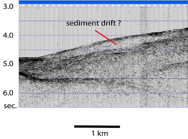
Fig. 4 Sediment drift at the foot of slope in the Makarov Basin
The upper part of the slope of Lomonosov Ridge below the unconformity show a prograding section towards Makarov Basin. However, a terrace at about 2000 meter water depth is associated with a major change in tilt; in deeper water towards the slope. The whole lower part of the slope appears to be formed by a large rotated fault block. At the foot of slope, we observe a deposit with seismic characteristic of a sediment drift (Fig. 4). This observation carries an interesting message about sediment supply and past contour-following bottom currents strong enough to generate sediment drifts.
We deployed the rock dredge several times in anticipation of possible outcrops of more competent rocks, but with negative results. The few fist sized rocks recovered are most likely glacial erratics.
We deployed the camera sled on top of Lomonosov Ridge in 1390 meters of water and obtained about 30 minutes of video footage. A short video segment of reduced resolution is attached to this
report. We would appreciate feedback from marine biologists regarding identification of the creatures captured by our bottom photography.
Being away
Field work requires you are away from home and from the office. How you cope with being away from home is a personal thing, coping with being away from the office is more of a perceptional issue (you imagine being indispensible?). Modern communication helps to almost eliminate the distance to a remote field location; the satellite phone is next to you and so is the e-mail.
It has been a busy week in the Sabvabaa office on the drifting sea ice over Lomonosov Ridge. This report was delayed, because the priority was to submit the final revision to Journal of Geophysical Research of our paper which reports the results of two seasons of vibroseis exploration of the sub-ice geology in Dronning Maud Land. This is a first on the Antarctic continent using the vibroseis technology and another joint cutting edge science venture with our German colleagues. A huge volume of volcanic rocks, about 250 km wide, extends for 1.700 km below the floating ice shelves along the Dronning Maud Land continental margin and has its age and compositional equivalent in similar volcanic rocks in South Africa (Lebombo and Mwenetzi_Save).
Today, your PC can do extensive scientific data analysis. Beyond that you need a library. John K. Hall, the owner of the hovercraft, has generated an updated digital library containing nearly 20.000 .pdf files of the published scientific literature for the Arctic Ocean in the fields of atmosphere, ice oceanography, geology and solid earth physics, all stored on a small hard disc. So the work place is as complete as possible for an ice-going scientific platform which has the scaled-down capabilities of any modern research vessel, but is only twice the size of a life boat.
No signs of animal life has been observed during the week
Life is treating us well.
Yngve Kristoffersen & Audun Tholfsen
Daily reports
Monday 20 October.
Position: 89 13.8' N, 149 23' W, temperature - 14 C, air pressure 1030 hPa, wind 5 knots from ESE. Ice drift 0.2 knots towards southeast. Shooting seismic reflection all day. Replenish high pressure air supply by running the main engine for fifteen minutes every two hours. Recovered dredge #3 at 0500 hours - came up empty. The water depth was 2325 meter. Lowered the rock dredge again. Checked the radiation flux instruments . Sun time detector covered with rime and IR detector with snow.
Tuesday 21 October.
Position: 89 11,5' N, 146 06' W, temperature - 14 C, air pressure 1029 hPa, wind 10 knots from ESE. Ice drift 0.1 knots towards southeast. Shooting seismic reflection all day. Recovered dredge # 4 at 1900 hours. Twelve fist sized rocks and one platy fragment in the bag, probably all glacial erratics. Deployed camera sled in 1390 meter water depth on top of Lomonosov Ridge at 2300 hours
Wednesday 22 ctober.
Position: 89 06.6' N, 140 44' W, temperature - 16 C, air pressure 1017 hPa, wind 15 knots from SE. Ice drift 0.4 knots towards southeast. Shooting seismic reflection all day. Audun discovered a new 3 meter wide crack in the ice only 5 meter behind the hovercraft in the morning. The crack stopped widening and closed later in the day with some shear motion. Audun packed up the 3.5 kHz echo sounder in case we had to relocate. We are on top of Lomonosov Ridge approaching the edge on the Makarov Basin side.
Thursday 23 October
Position: 89 01.8' N, 137 5.3' W, temperature - 17 C, air pressure 1023 hPa, wind 8 knots from SE. Ice drift 0.2 knots toward southeast. Shooting seismic reflection all day. We could see on the seismic record that the top cover of sediments (c. 200 m thick) was thinning and sediments below an underlying angular unconformity was likely to be exposed at the sea bed. Dropped the small gravity corer at 1000 hours targeting a suspected exposure. Had problems with the capstan drum so the core was not recovered until 8 hours later. Recovery was 20 cm. of very cohesive light brown sediments. No significant ice activity observed today.
Friday 24 October.
Position: 88 55.2' N, 134 37' W, temperature - 11 C, air pressure 1016 hPa, wind 23 knots from SSE. Ice drift 0.5 knots towards southsoutheast. Dropped dredge # 4 to the seabed at 2400 meter depth just after midnight just in case any rock
exposures would appear. Shooting seismic reflection all day. No significant ice activity observed .
Saturday 25 October.
Position: 88 49.6' N, 134 32' W, temperature - 10 C, air pressure 1016 hPa, wind 13 knots from the NNE. Ice drift 0.1 knots towards northeast. Shooting seismic all day. We just reached the foot of slope of Lomonosov Ridge in the Makarov Basin. The ice drift now turns back up the flank of the ridge. Recovered an empty dredge # 4
Sunday 26 October.
Position: 88 57.7' N, 132 22' W, temperature - 21 C, air pressure 1022 hPa, wind 4 knots from NE. Ice drift 0.2 knot towards northeast (back across Lomonosov Ridge). Acquiring seismic reflection data all day. We are moving upslope. Dropped the dredge in 26660 meter of water. Audun is working on getting our sauna finished.)