(27 Oct. - 3 Nov. 2014)
Ice drift
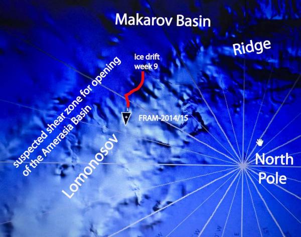
The ice camp moved about 25 nautical miles (46 km) during the week (Fig. 1). We moved from the foot of slope in the Makarov Basin with water depth 4000 meter to the upper slope of Lomonosov Ridge with water depth of about 1700 meter. The weather situation has been characterized by a weak high pressure and very weak pressure gradients. No low pressure system reached into the central Arctic Ocean. As a result, the ice drift has been slow (0.2 knots) and from Wednesday 29 Oct. about 0.1 knots on a steady course towards the Fram Strait. To get the seismic reflection data, we fire a shot every 25 meter and with the slow ice drift, we needed 16 minutes to cover that distance.

Fig. 1 Drift track of FRAM-2014/15 across Lomonosov Ridge during week 9
Sea ice dynamics
We have not noticed any sea ice activity; formation of new cracks or motion of pressure ridges during the week.
Camp life
Temperatures were -17° C to - 21° C during the first part of the week, but fell to - 27° C to -29° C after Thursday 30 Oct. When the temperature approaches minus 30° C, and there is 10 knots wind, the wind chill makes the felt temperature below minus 40° C. Work outside gets more difficult. We run the generator around the clock, because it gets difficult to start below minus 15° C, but more importantly, we need to keep the compressor warm at all times and also to heat the main engine. The main engine always starts on the first turn and it is needed for driving the hydraulics to power the winch and the compressor.
Science
We are overseeing the following suite of continuous measurements:
Bathymetry and sub-bottom profiling:
- five autonomous echo sounder buoys reporting to shore via Iridium
- seismic reflection (0.3 litre air gun & single hydrophone), sub-bottom penetration ̴2 km
Oceanography:
- Acoustic Doppler Current Profiler 0- 500 meter depth
- two Aanderaa current meters at 800 and 1050 meter depth, respectively.
- thermistor string with 30 thermistors from the surface to 300 meter depth.
Atmosphere:
- measurement of incoming and outgoing radiation from the ice surface
- surface infrared skin temperature
- sun time
- Aanderaa weather station (wind, temperature and humidity)
The seismic reflection measurements continue to run well in spite of air temperatures approaching minus 30° C. The operation has stabilized for the critical part which is the hydraulic drive of the compressor and the compressor itself. The temperature in the water is of course stable at minus 1.7 ° C. We may at times get a misfire for about every 20th shot, but injection of alcohol into the air line appears to cure the problem
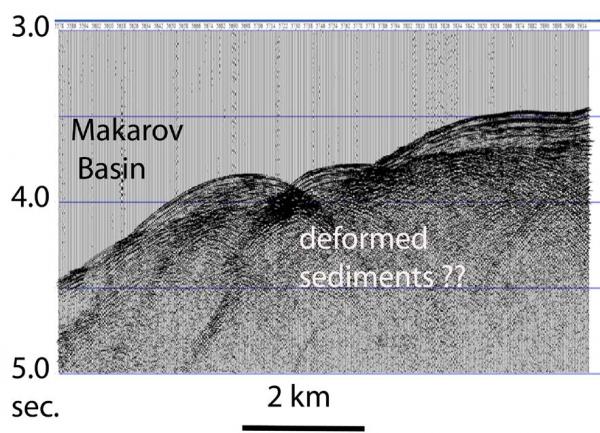
A characteristic opaque seismic reflection event appears in the area near the foot of slope of Lomonosov Ridge (Fig. 2). The acoustic image suggests an irregular upper surface and possible internal stratification remains unresolved. However, it does not have the characteristics of a hard rock interface, and deformed sediments is our favored preliminary interpretation of the unprocessed data (Fig. 2). One of the main scenarios for opening of the Amerasia Basin is shear along the foot of slope of Lomonsov Ridge in the Makarov Basin ( see Fig. 1). Evidence of deformed sediments is found on several other seismic profiles reaching beyond the foot of slope and intersecting the main linear features of partly buried topography.

Fig. 2 Sediments at the foot of slope in the Makarov Basin

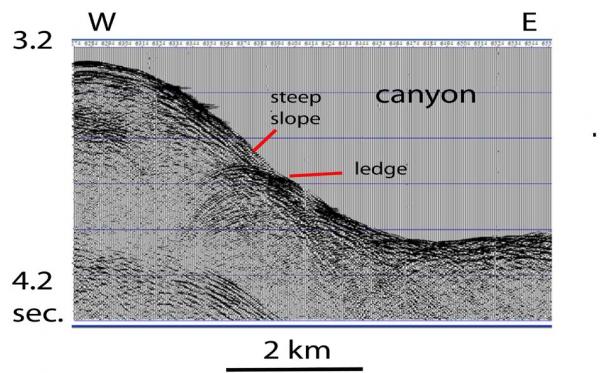
Fig. 3. Canyon on the lower Lomonosov Ridge slope facing Makarov Basin
On the lowermost part of the slope, we were drifting into a canyon which had one significant ledge along its western side (Fig. 3). We had the rock dredge out, but the dredge came up empty except for two fist sized rocks, most likely glacial drop stones. Movi ng out of the canyon over its more gently sloping eastern side, we dropped the core over a small ledge, but recovered only 1 meter of brown mud, most likely all recent sediments.
The sediments below the slope of Lomonosov Ridge along our drift track, appear almost transparent deeper than about 0.4 sec. below the sea bed. One possible explanation is a very homogenous sediment package which is kind unusual for a continental margin.
No signs of animal life has been observed during the week
Life is treating us well.
Yngve Kristoffersen & Audun Tholfsen
Daily reports
Monday 27 October.
Position: 88 54.1' N, 129 32' W, temperature - 17 C, air pressure 1022 hPa, wind 8 knots from NE. Ice drift 0.1 knots towards northeast. Shooting seismic reflection all day. The rock dredge is out.
Tuesday 28 October.
Position: 88 53,8' N, 124 32.7' W, temperature - 19 C, air pressure 1024 hPa, wind 9 knots from E. Ice drift 0.2 knots towards east. Shooting seismic reflection all day. We are moving along the lower slope and start crossing a canyon. The rock dredge is out.
Wednesday 29 ctober.
Position: 88 53.1' N, 122 55' W, temperature - 19 C, air pressure 1019 hPa, wind 8 knots from SE. Ice drift 0.4 knots towards southeast. Shooting seismic reflection all day. Recovered the rock dredge at 0200 hours. The dredge contained two small rock pieces, most likely glacial erratics. We drifted out of the canyon during the evening. Dropped the corer on a ledge in 2930 meter water depth and recovered 1 meter of brown mud, probably all recent sediments. Submitted and uploaded via internet the final revision of our paper to Journal
of Geophysical Research on the first vibroseis exploration of the sub-ice geology on the Antarctic continent.
Thursday 30 October
Position: 88 52.7' N, 121 48.7' W, temperature - 18 C, air pressure 1015 hPa, wind 3 knots from ENE. Ice drift 0.1 knots toward east. Shooting seismic reflection all day.
Friday 31 October.
Position: 88 53.8' N, 120 18' W, temperature - 23 C, air pressure 1016 hPa, wind 10 knots from NW. Ice drift 0.1 knots towards northeast. Cleaned the deck area and put the cover over the insulation mats over the cabin part of the hovercraft superstructure.
Saturday 01 November.
Position: 88 56.2' N, 117 47.8' W, temperature - 27 C, air pressure 1016 hPa, wind 16 knots from the N. Ice drift 0.1 knots towards east. Shooting seismic all day. We are passing 1800 meter water depth on our way up the slope of Lomonosov Ridge. The ice drift is very slow as it takes 16 minutes to move the 25 meter between each seismic shot.
Sunday 02 November.
Position: 88 57.0' N, 115 58' W, temperature - 27 C, air pressure 1015 hPa, wind 2 knots from NNW. Ice drift 0.1 knot towards east. Checked radiation flux instruments. Radiation sensors are fine, sun time and IR skin temperature detectors completely covered with frost. Took sun time detector inside to thaw out. The weather station sensors were also completely covered with frost.

